If that is the case, I have absolutely no interest in that product.
I think this is the bit that many don’t seem to have realised, that MSFS has brought together a lot of technologies to create something rather special.
Worldwide satellite photography, coupled with above average autogen, and photogrammetry, all streamed over the Internet.
There isn’t anything like it, and whatever XP12 is going to be like, it won’t be like this. The closest it would come is MSFS running in offline mode.
One of its big selling points is the huge community driven scenery gateway.
That’s what Ms/Asobo need to concentrate on, not updating Bing imagery. When we get that, and the community can get to work updating autogen airports, the sim will be in a much better place.
I agree with everything you said, plus updating Bing imagery in areas that presently have no coverage, with the understanding that it takes time to work through the Blackshark/AI system. The areas without Bing coverage is effectively running in offline mode, which IMHO looks terrible. I think it’s a “both, and”, not an “either, or”.
Did you submitted to Zendesk? These are Bing layers from altitude, (multiple layers image) can be fixed, they fixed a lot previously that I submitted.
You can clearly see there is a lack of available data for much of the globe. There may be a business opportunity there for you. Just build a new imaging satellite and start scanning. You could sell the data to Bing and we would reap the benefits.
Then again, maybe the reason no-one has bothered to shoot hires satellite imagery of the remote portions of the planet is that there is no market for it. If there is no money in the data, no-one is going to rush out and spend literally billions (yes, with a ‘b’) on satellites, launching, and up/down link hardware, staffing and data scrubbing.
@GlobalFlyer2020 I am in full agreement that it would be nice if I could go fly VFR in Northern Canada and not constantly have the ground change back and forth between snow with frozen rivers and lush green forest textures. Not happening in my lifetime. There needs to be a political will from the countries involved to image areas they have no particular interest in, if you want public domain data. Yes there are private satellites getting amazing imagery, but it is proprietary data that they will not happily share, even at a cost.
The imagery on Bing AND Google for my region is spotty at best and most WAY out of date. There is a proprietary agriculture app available though that can adjust a herbicide sprayer travelling across a farmers field, in real time, with near instant communication depending on the type of foliage the satellite is seeing. Can you spot Wild Oats in a Barley field on Google Maps? Pretty sure that that kind of data will not show up on Bing Maps either, anytime soon.
Wow… puttin’ in some hours! Cool project, thank you for sharing.
Yes, even Google is lacking detailed satellite data, sufficient for low altitude flying textures, in extreme polar regions (e.g. parts of Nunavut and Greenland, Antarctica, etc.); however, most great circle routes rarely fly that high.
Understand certain areas will never get Bing satellite data. I get it. My suggestion for those areas without satellite data is to have better generic region specific textures. Most regions indeed have some satellite data that can be used to significantly upgrade the generic textures, and make different region specific textures for different land classes vs. using the same cartoonish generic textures across the entire world.
For example a generic “farm texture” in the Middle East should look different from a farm in Russia vs. South America vs. Africa. Same with cities/towns/prairies/forests, etc. (e.g. generic taiga forest is different than temperate forest vs. tropical rainforest, etc.) All of these subclasses have actual Bing satellite data of that type at least “somewhere” in a general region that can be used to substantially improve the generic textures.
That takes “some” effort, but is not terribly difficult and much less involved than getting actual satellite data for the remote areas that no parties have an interest in. That would also have a secondary benefic of substantially improving the texture experience in offline mode.
I think their definition of the word “great” is much like their definitions of “premium” and “deluxe”. They don’t quite line up with what Webster and the rest of the word have in mind.
Indeed. Google also has 10+ years up on everyone else collecting this type of data. No one else was doing it because it was expensive to collect and they couldn’t figure out how to make money on it. It took a few years, but when Google managed to market their data, MS (Bing) and Apple jumped on that train as well and tried to cash in.
So it should be no surprise to anyone that Google data is generally much higher quality and far more complete than their competitors’.
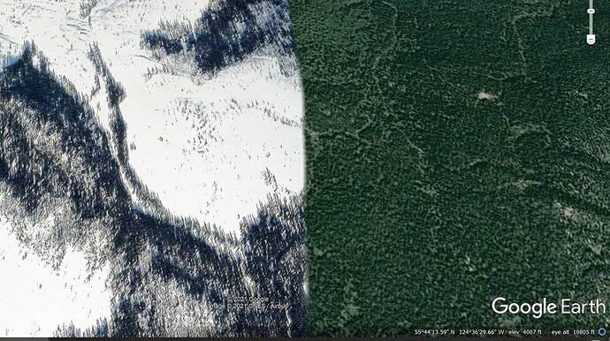
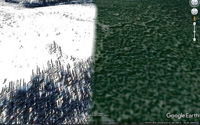
Not sure I understand what you’re showing. They both look like acceptable satellite data to make textures from, and look like Taiga spruce boreal forest, with the left being snow covered in winter and the right in the summer.
and it doesn’t bother you when flying over a region to have both seasons out the window?
The data for both seasons over the entire are is unavailable and the AI is incapable of producing tiles from data that does not exist.
Good data then bad data in a span of 100 metres…
Unfortunately the good data is perpetual winter.
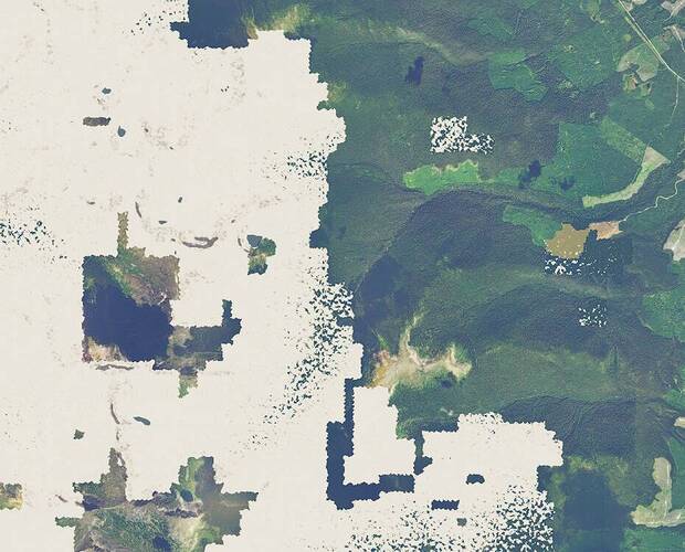
Thanks for that illustration and perspective. What does Bing have for that exact location, and what does MSFS2020 presently look like at that exact location?
Modern Bing may be superior than Google Earth in some cases and vice versa. Point taken. Thanks for the illustration.
Understand MS/Asobo will take years and slowly integrate those areas into the sim. With that said, I really think there is a need to significantly improve the generic textures and make them region specific. For example, my screenshot above can clearly be used to make a “generic” boreal forest texture landclass.
Thanks for showing that. I clearly got the wrong area and Bing also has issues as Google. Clearly the generic textures are terrible and could be much improved.
It will not necessarily take years, a few weeks ago when there were problems with the bing data for a couple of days in my hometown in South America the most updated images of bing appeared in the simulator. Unfortunately this only lasted a single day and then the old bing images that we are used to seeing again reappeared. So if they can put the most current images, I think the problem goes with blackshark ai to create the new houses and updated buildings.
It seems like the path forward would be:
-
Update MSFS2020/Blackshark with existing modern Bing data. That is something MS already has in Bing.
-
Put effort into significantly updating the generic textures and also making them region specific. These look TERRIBLE. Seriously, they look like a 1990s video game. That would help the areas without satellite data and where there will never be satellite data and also significantly improve offline mode. I’m sure a company like ORBX could do it, make it region specific and include seasonal variation, but then it would be extremely expensive and cause CTD on sim updates.
Yes lot of hours to do that.
André Vaillancourt
You know, I done a lot of Ortho Scenery for Aerofly FS2. For example the Czech Republic. I ended up mixing Bing data and Google Earth data (or even a third recource). Aproximately 50:50 because each source does NOT cover the complete country in any acceptable quality. Huge areas of clouds here, much dark areas there. Different seasons and so on.
So I find it absolute fantastic what they have done in MSFS for the whole world using only one source.
Much more important than outdated (what is outdated? Do we need live data here?) Bing data.
Sure, there is always room for improvements. But we have more important flaws in the sim than outdated orthos.


