I would like to see more photogemmetry scenery and a lot more famous landmarks around Britain and Ireland as it hasn’t been completed with the recent update 16th February 2021. I am hoping to find more and more towns and cities with photogemmetry data. Along with man made Tamar and Royal Albert bridges. Plymouth breakwater and Eddystone lighthouse seen from Plymouth.( 14 miles out in the English Channel) would be great to find in the simulator. I would also like to see my local (real life closed airport) Plymouth re instated in the simulator. It need not be closed in the simulator, thank you. ![]()
I can’t help you with a man-made Tamar bridge, but I use those two, and I think it’s quite a nice addition
Yes I have the same, but it would be good to have the entire city in photogrammetry, just like Bristol. You can do it yourself, but there is a fault with the “unknown” errors in the software to install the scenery into the simulator.
I can only recommend to contact Thalixte or MarkTaylor on Flightsim.to. They have by far the most experience. Maybe they know something.
Exactly! And isle of a man could be great too
Frankly the UK and Ireland is pretty poor across the board, unless you use a lot of add on scenery. Generic bridges, vehicles crossing bridges on the water surface, airfields that bear absolutely no similarity to the real thing (although I guess that the major airports are better - don’t use 'em) etc. I could go on but I haven’t got all day. Ireland is even worse than the UK.
So - yes a further update would be great, most especially if it incorporated additional ATC frequencies to our ‘silent’ airfields.
I certainly think another UK update is needed as they’ve barely scratched the surface so far, much of it’s current TIN is some of the worst in the sim & the UK is in pretty poor standing overall, especially when compared with the two other high player bases in America & Germany.
I’d very happily see Africa, South America or Scandinavia (with photogrammetry this time) get the WU treatment before or after the UK.
Below are some carefully chosen suggestions for UK updates.
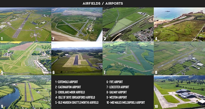
I’ve gone with a mix of smaller airfields & airports as that is Asobo’s style. The less work needed on each, the more can be made. I’ve tried to choose places that haven’t been done by 3rd party for MSFS yet & are located in interesting places. I also believe Orbx has previously made a few of these in the past which would probably help towards bringing them to MSFS.
- England
Old Warden (Shuttleworth) Airfield, Cotswold Airport, Crosland Moor Airfield, Leicester Airport
- Wales
Mid Wales (Welshpool) Airport, Caernarfon Airport
- Ireland
Galway Airport, Weston Airport
- Scotland
Fife Airport, Isle of Skye (Broadford) Airfield
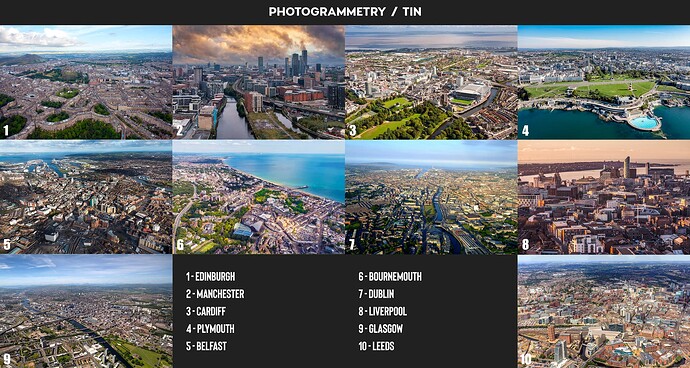
The picture above only consists of a small group of the major cities missing & those that i would prioritise (along with current cities that could be improved/replaced) for a UK WU 2. Considering the large amount of major cities currently missing photogrammetry, the suggestions below would go towards a following UK CU… or 2… or 3.
Also, the UK cities that have been done but unfortunately have pretty poor data are not listed below. Hopefully those can also be replaced at some point. They include London (everything within the M25 motorway), Cambridge, Oxford & Bristol. Nottingham has decent quality photogrammetry but also only covers a tiny area of the city. Brighton has water mask issues & Eastbourne has terrain colouring issues.
- England
Poole, Exeter, Weymouth, Torquay, St. Ives, Glastonbury, Bath, Salisbury, Windsor, Reading, St. Albans, Swindon, Gloucester, Cheltenham, Painswick, Canterbury, Rochester, Southend-On-Sea, Margate, Maidstone, Dover, Worthing, Bexhill, Hastings, Folkestone, Luton, Warwick / Royal Leamington Spa, Northampton, Stoke-on-Trent, Milton Keynes, Wolverhampton, Coventry, Ipswich, Colchester, Norwich, Leicester, Peterborough, Sheffield, Huddersfield, Bradford, Blackpool, Preston, Blackburn, Bolton, Hull, York, Lincoln, Middlesbrough, Sunderland.
- Wales
Swansea, Caernarfon, Newport
- Ireland & NI
Cork, Bray, Derry, Galway, Limerick
- Scotland
Aberdeen, Dundee, Inverness, St Andrews
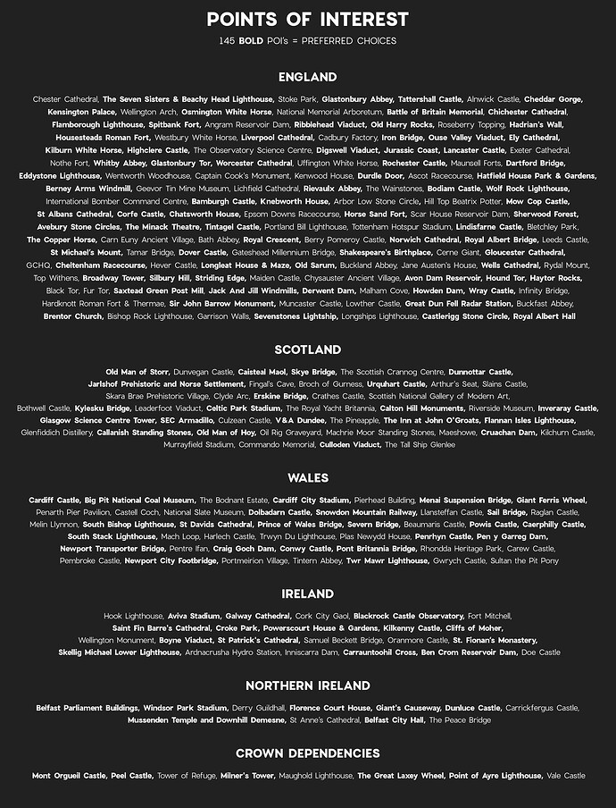
Took a while but these are some of the more noticeable POI’s currently missing. I’ll probably have missed some obvious one’s but the list above includes 262 POI’s (i believe), 145 of which are in bold & the one’s that i think would be best.
- Bing Satellite Data & DEM
Much of the UK’s fields look dark & desaturated which makes flying over them a bit dreary when in reality, the country is green & lush most of the year. Some area’s show this off well but sadly it’s not the case in most places, typically more east. Would be great to have some better quality & more saturated satellite imagery.
DEM could always be improved to better represent the shape of the country. Again, improvements anywhere across the country would be good but places like coastlines or the Lake District, Peak District, York Moors & Dales, Dartmoor, Snowdonia & Scottish Highlands would show it off best as most lack any sharpness.


