Welcome to the 28° North Community Flying Event!
Inspired by the Crossing the North Atlantic in a Cessna Series by Matt Guthmiller, Louis Cole and Juan-Peter Schulze, during this event we will cross the Northern Atlantic in GA aircraft.
Update! Read the section below!
Day 2 - Edits, Impressions and Plans
Although I couldn’t join the event on time, because I had to help someone, I managed to fly the legs from Ormond Mun. to Georgetown County.
I had a lot of fun even if I just saw people flying roughly the same route.
There was a small thunderstorm over Savanna which was a nice change from the light clouds encountered on the rest of the trip. I’ve also seen some conflicts of people landing in opposite directions on the same runway, but as far as I am aware nothing serious.
However there was a lot of confusion about the communication on Discord and grouping up with other pilots.
- There is no ATC coverage for the event. If you want, feel free to announce procedures (taxi, final, leaving runway, etc.) like you would in uncontrolled VFR airspace, although this is not required.
- We will discontinue using the Flight Events Discord Bot since it was developed for use with ATC. This will prevent people from sitting in 5 different voice channels. Instead, we will be using the Event #1 and Events #2 voice channels on the official Discord under -Events-.
- Since many people were getting a bit lost by flying alone I would propose continuing the event in one or more groups. @MRSALT did a great job yesterday of leading a group of pilots along the waypoints.
- We will start out as a group on each airport, then start taxiing at the same time, flying towards the next airport in a formation or each pilot on their own, then land and taxi to the GA parking area, where we will refuel and wait until most of the pilots have arrived. We will then continue towards the next airport like before. Any pilots that have not landed yet can continue flying to the next airport without landing if their fuel reserves allow them to save some time and catch up with the others.
As @MRSALT 's group managed to fly to Easton/Newnam (KESN) yesterday, I would propose to continue flying from that location again today at 1600z.
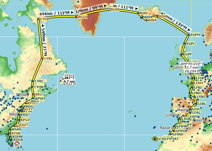
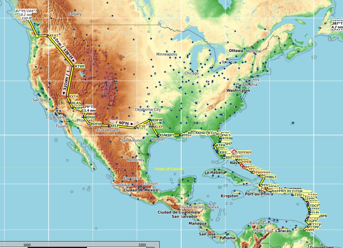
Our Route will lead us from 28°N latitude in sunny Florida along the East Coast of the United States up to the untouched wilderness of Quebec, Canada. After flying over the Hudson Strait we will make one last stop in Iqaluit before crossing over to Greenland. After being able to enjoy the icy beauty of Greenlands icecaps, our next step will be flying to the volcanic island Iceland. From there on we will fly towards Scotland and then continue straight down the United Kingdom and further down the West Coast of Europe and Africa until we end our trip on the breathtaking Canary Island of Tenerife with its 3.718m tall Volcano “Mount Teide” at 28°N latitude.
Departure takes place on 2020-08-28T16:00:00Z, so make sure to spawn in around 15 minutes earlier.
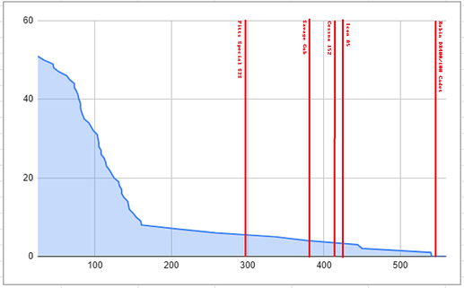
The route is designed to consist of many shorter hops, so that all propeller aircraft will be able to complete most of the legs. Only the Pitts Special S2S, Icon A5, Cessna 152, Savage Cub and Shock Ultra won’t be able to complete some of the actual Trans-Atlantic legs (As marked in red and yellow on the map).
Also this way those of you who don’t have enough or continuous spare time to fly the complete route will be able to participate by flying only a few hops.
You can of course decide to skip some landings and fly directly to the farthest airport your plane can manage. The frequent landings are only meant to generate some variety, so as not to sit in front of the PC for hours doing almost nothing and leaving the rest to the Autopilot. Also they are meant to be able to group up with friends on the apron of the Airports and maybe enjoy some tea or coffee during a short break before taking off again.
Most airports have been chosen as to include a hard surface runway and enough parking space on the apron for around 15-20 planes at a time.
Map
Route
| Departure | Arrival | Distance | Remarks |
|---|---|---|---|
| Melbourne Intl. (KMLB) | Ormond Beach Mun. (KOMN) | 76NM | — |
| Ormond Beach Mun. (KOMN) | Fernandina Beach Mun. (KFHB) | 81NM | — |
| Fernandina Beach Mun. (KFHB) | Savannah/Hilton Head Intl. (KSAV) | 92NM | — |
| Savannah/Hilton Head Intl. (KSAV) | Georgetown County (KGGE) | 119NM | — |
| Georgetown County (KGGE) | Brunswick County (KSUT) | 73NM | — |
| Brunswick County (KSUT) | Pitt-Greenville (KPGV) | 108NM | — |
| Pitt-Greenville (KPGV) | Richmond Intl. (KRIC) | 112NM | — |
| Richmond Intl. (KRIC) | Easton/Newnam (KESN) | 98NM | — |
| Easton/Newnam (KESN) | Summit (KEVY) | 46NM | — |
| Summit (KEVY) | Reading Rgnl./Carl A Spaatz Field (KRDG) | 53NM | — |
| Reading Rgnl./Carl A Spaatz Field (KRDG) | Orange County (KMGJ) | 103NM | — |
| Orange County (KMGJ) | Westfield-Barnes Rgnl. (KBAF) | 79NM | — |
| Westfield-Barnes Rgnl. (KBAF) | Lawrence Mun. (KLWM) | 78NM | — |
| Lawrence Mun. (KLWM) | Portsmouth Intl. at Pease (KPSM) | 25NM | — |
| Portsmouth Intl. at Pease (KPSM) | Bethel Rgnl. (0B1) | 81NM | — |
| Bethel Rgnl. (0B1) | Quebec/Lesage Intl. (CYQB) | 114NM | — |
| Quebec/Lesage Intl. (CYQB) | Chicoutimi/St. Honore (CYRC) | 105NM | — |
| Chicoutimi/St. Honore (CYRC) | Fermont Airport (CYFV) | 234NM | IRL this airport is Aéroport de Gagnon (CYGA) |
| Fermont Airport (CYFV) | Schefferville (CYKL) | 117NM | — |
| Schefferville (CYKL) | Iqaluit (CYFB) | 540NM | see “Plane Range” |
| Iqaluit (CYFB) | Nuuk (BGGH) | 444NM | " |
| Nuuk (BGGH) | Kulusuk (BGKK) | 379NM | " |
| Kulusuk (BGKK) | Rif (BIRF) | 336NM | " |
| Rif (BIRF) | Reykjavik (BIRK) | 67NM | — |
| Reykjavik (BIRK) | Bakki (BIBA) | 59NM | IRL this Airport is Bakkaflugvöllur |
| Bakki (BIBA) | Hornafjörður (BIHN) | 137NM | — |
| Hornafjörður (BIHN) | Scatsta (EGPM) | 450NM | see “Plane Range” |
| Scatsta (EGPM) | Wick (EGPC) | 131NM | — |
| Wick (EGPC) | Glasgow (EGPF) | 161NM | — |
| Glasgow (EGPF) | Leeds Bradford (EGNM) | 154NM | — |
| Leeds Bradford (EGNM) | Wolverhampton (EGBO) | 84NM | — |
| Wolverhampton (EGBO) | Shoreham (EGKA) | 125NM | — |
| Shoreham (EGKA) | Rouen/Vallee de Seine (LFOP) | 104NM | — |
| Rouen/Vallee de Seine (LFOP) | Le Mans Arnage (LFRM) | 95NM | — |
| Le Mans Arnage (LFRM) | Biard (LFBI) | 82NM | — |
| Biard (LFBI) | Merignac (LFBD) | 114NM | — |
| Merignac (LFBD) | Blagnac (LFBO) | 115NM | Airbus Headquarters at the Airport |
| Blagnac (LFBO) | El Prat, Barcelona (LEBL) | 143NM | — |
| El Prat, Barcelona (LEBL) | Manises (LEVC) | 160NM | — |
| Manises (LEVC) | Alicante (LEAL) | 73NM | — |
| Alicante (LEAL) | Almeria (LEAM) | 122NM | — |
| Almeria (LEAM) | Gibraltar AB (LXGB) | 150NM | — |
| Gibraltar AB (LXGB) | Saiss (GMFF) | 135NM | — |
| Saiss (GMFF) | Mohammed V, Casablanca (GMMN) | 135NM | — |
| Mohammed V, Casablanca (GMMN) | Menara (GMMX) | 108NM | — |
| Menara (GMMX) | Al-Massira Intl. (GMAD) | 105NM | — |
| Al-Massira Intl. (GMAD) | Page Blanche/Tan Tan (GMAT) | 145NM | — |
| Page Blanche/Tan Tan (GMAT) | Lanzarote (GCRR) | 132NM | — |
| Lanzarote (GCRR) | Fuerteventura (GCFV) | 33NM | — |
| Fuerteventura (GCFV) | Gran Canaria (GCLP) | 86NM | — |
| Gran Canaria (GCLP) | Tenerife Norte/Los Rodeos (GCXO) | 60NM | — |
| Tenerife Norte/Los Rodeos (GCXO) | Tenerife Sur/Reina Sofia (GCTS) | 29NM | — |
Plane Range
As stated before, the route is designed in a way that all planes should be able to fly most legs with their available range. However, this is not always possible due to a lack of airports in e.g. province of Quebec or the legs being transoceanic.
Therefore, the following planes will not be able to (safely) fly these legs:
| Plane | Range | From | To | Distance |
|---|---|---|---|---|
| Pitts Special S2S, Shock Ultra | 298NM, 323NM | BGKK | BIRF | 336NM |
| Savage Cub | 377NM | BGGH | BGKK | 379NM |
| Cessna 152, Icon A5 | 415NM, 427NM | CYFB | BGGH | 444NM |
| BIHN | EGPM | 450NM | ||
| Robin DR400 | 550NM | CYKL | CYFB | 540NM |
Below is a graph which shows the cumulative amount of legs on the y-Axis and their respective lengths in NM on the x-Axis along with red lines marking the maximum range of the relevant planes.
You may be able to shorten some of these legs as indicated on the MyMap by the green icons. However these marked airfields are currently missing in the sim, so you would have to land on a empty/grassy field and pretend that there is an airport there which you would be able to refuel at.
Sights
Sights are marked on the MyMap as red icons, each icon representing the type of the sight. These are for those of you who want to do some VFR sightseeing parallel to travelling from A to B.
Since I have not been to most of these places and it is very time consuming looking up possible sights which are relevant to VFR pilots, I would invite you to reply with sights or places along the route you know by copy-pasting the following format:
| Name | Type | Location | (Coordinates or Plus Code) |
|---|---|---|---|
| example1 | golf club | west from city xyz | 44°51’00.4"N 0°34’17.4"W; VC2H+29 |
| … |
I will then be able to add them to the map for everyone else to see.
Simulator Setup
Server: East USA
Multiplayer: All-Players
Live traffic: No
Weather: Live Weather
Time: Live
Remember to re-select all of the options in the settings if they are already selected.
As stated above, we will use Live-Weather. If the weather becomes too unfavorable to continue for multiple days, we will announce to switch to a specific preset.
Communication
We will be using the text and voice channels under -[Flight Events]- on the Official MSFS Discord
Under fe-guide you will find instructions for the Flight Events Discord Bot, which after you have linked your Discord account with it, will move you to the room corresponding to the COM1 frequency you have set in MSFS. Instructions for Flight Events and Discord-connection can be found here: Flight Events manual
EDIT: We will be using the text and both voice channels (Events #1 and Events #2) under -[Events]- on the Official MSFS Discord .
Flight Tracking and Multiplayer
Other players are visible on the map, but not very noticeable yet. Therefore we will use the Flight Events app and its website. https://events.flighttracker.tech/
This is meant to be a semi-realistic event. Everybody is welcome, no matter the amount of experience. However, please adhere to some general rules:
- Do not spawn on the runway. Use the “Zoom into Details” function in the world view to select a gate or ramp.
- Do not use Slew unless needed. You may use slew to change the gate/ramp you spawned in to avoid restarting, in case it is already occupied by another player.
- Fly traffic patterns. This helps avoid frustrating situations due to traffic conflicts.
- Watch out for traffic. Do not taxi onto the runway if there is a plane on short final or the runway and vice versa, don’t land/go around if other planes are still on the runway or on final in front of you.
- Do not take off on taxiways and do not overtake other taxiing aircraft.
- Avoid erratic maneuvers as well as aerobatics.
- Keep your distance to other planes unless you directly coordinated a formation flight with them.
EDIT:
- Use the active runway for takeoff and landing. You can get the active runway either from ATIS or by looking at the wind direction. Always land into the wind and not in the opposite direction.
Footage
We would like to create a short movie of the event afterwards. For that it would really help if you could save a few videos from your flights, preferably without HUD or any other UI elements. Maybe even with audio from communicating with other players, although make sure to get their consent first.
You can send me a link to your footage via Discord (Jolly#7806).
Conclusion
If there are any questions, you can post them as a reply under this post or ask me directly on Discord (Jolly#7806).
Safe landings and stay healthy!


