Yes I’m aware of that as well. And I actually thought that was a smart approach, despite the sometimes drastic changes in wind and pressure. I was hoping this update would mitigate those instances.
But another problem with metar is that not all cloud layers are covered. CAVOK, for example, means that visibility and clouds below 5000 feet are fine. But what if there is an layer overcast layer on 15000 feet, or two layers above an overcast layer that cannot be detected from ground? They may not be displayed at all?
I think that dynamic meteoblue system was more realistic, although not always up-to-date and accurate.
1 Like
Simulate AWOS in the sim of the current weather in the sim then. Make a snapshot of the current weather in the sim and report it back to us. That way they not need match the current real world weather. The AWOS need to match the current weather in the sim though. Then we should not compare it with the real world weather because we are not flying in the real world. We are using a sim while flying.
If we set a custom weather as we want to have it and know what type of weather we set in the sim we can plan the flight with that settings but it will not match the current world weather.
They need to give us right information in ATIS to be able to plan the flights correct. They do not need to have the current world weather in there. ATIS has been a problem from release that it did not provide us with correct data. I think that is the main problem from beginning.
We strive to somehow get correct data if we can’t get it in the sim. Thats why many want to have METAR in the sim because they are reported often correct data.
2 Likes
This is why the approach prior to SU7 was working since clouds and precip came strictly from Meteoblue and it could interpret the many different cloud layers at higher altitudes.
But since they’ve not provided any details on how METAR is being blended in the current weather iteration, all of us are just speculating as to what’s wrong since we don’t really know how it’s supposed to work in the first place.
To stay fair, that isn’t the issue. If it were, the cloud bases would be right at the coast where AGL is more or less the same as MSL, instead of lying around in the fields. ![]()
Investigation yeah !! Thanks for it !
I don’t know this for certain, but it would be logical to think that there would be an upper altitude limit on where clouds would come from the METAR rather than from the MB model. It is probably (at most) a few thousand feet. In the METAR-based airport surface wind, temperature and pressure that were added to Live Weather last year, the transition between METAR and forecast model values appears to happen at 1500 feet AGL and within a 5 mile radius of an airport. I am very sure about the transition altitude for wind - I have tested it many times - not sure about the transition for temperature or pressure.
Thanks for the update. I hope they aren’t going to make us wait until the next planned update in February to get this fixed?
1 Like
i suppose aerosoft need implement the new HUD in the su7
1 Like
Great find, this would explain a lot. 
1 Like
This probably explains my observation that clouds are way too close to the ground in general.
1 Like
I wonder if the problem is elsewhere, since if it was a matter of cloud height vs cloud altitude translation it should not occur at an airport near sea level (where height and altitude are the same). But it does.
Yeah, the HUD has changed, they need to adjust it. I hope they can do it very soon, as it is really the time of the year where a HUD comes in handy… 
When MSFS first came out last year, there were definite issues in the first two versions of the sim with clouds often sitting right on the ground. I used to see this all the time when flying in Southern California. This was also the era when upper level winds were inoperative over the entire United States - the winds were always 253 degrees at 3 knots. Both problems were fixed at about the same time - (last autumn).
I have seen no regression of problems with upper level winds since METAR clouds were introduced in SU7, but there appears to be an issue with how lower-level cloud heights are calculated. I suspected that this would be a challenge to implement, since “observed” METAR cloud heights are expressed as AGL altitudes above the airport making the METAR observations - and “predicted” clouds in a weather model are stored as absolute altitudes MSL.
2 Likes
I fly on archipelago area… that explains why I don’t have this cloud issue.
1 Like

Lots of clouds sitting at 0 MSL in Florida yesterday morning. Bases were low per observations, but not quite that low. Sometimes I wonder if they have difficulty actually controlling the bases and tops. As in they can fill a voxel of air with a particular pattern of weather, but don’t have control over some of the specifics, and perhaps the predefined voxel layers actually define where they can put bases and tops.
2 Likes
I’ll take reported weather even if it’s slightly “old” over predictive weather ALL DAY LONG. Predictive is just that, a best guess based on models. Now, I’ll take a nice blend of METAR with predictive.
I guess in the end, it will need to be a user-selectable option, not one or the other forced upon us.
2 Likes
Agree with that.
I choose meteoblue weather for sure. The thing is we all have different opinions about it and thats why we need options when they add something that completely overhauls what we are used to and liked. Not everybody complained about the system before. I understand that many wants to have METAR integrated but it should not be forced on us who don’t like that approach.
I tried METAR already in the sim with unreal engine and rex and i always switched over to live-weather. Now i’m forced to use it anyway ![]()
Rex and unreal weather works better because they add that local report and sets it everywhere. That is not realistic in my opinion.
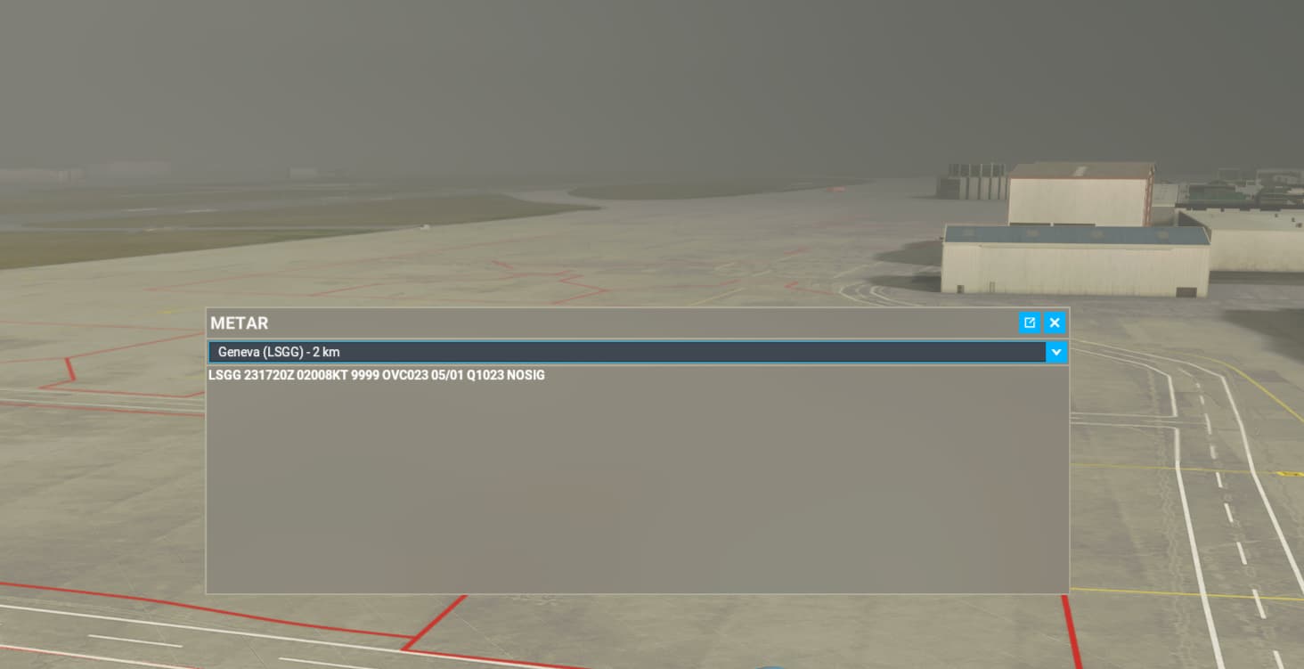
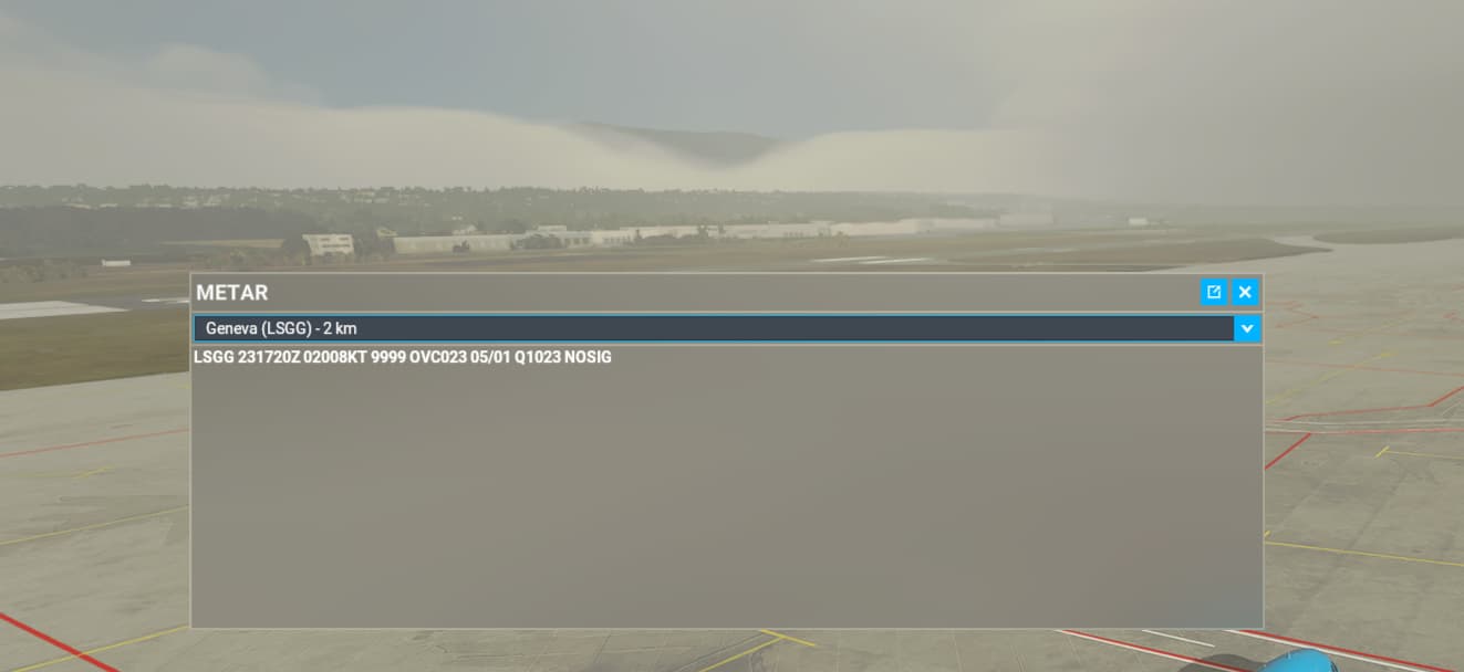
Just made a flight in Iceland, the metar says clouds few 1.200 ft cumulinimbus, SCT 4.100 ft and BKN 7000 ft.
The clouds where on the ground and on sealevel above the sea.
So it’s not (only) injected in MSL in stead of AGL…its just injected on and below MSL.
2 Likes