yes exactly, that’s why a few hours earlier after trying a few airport I came to the conclusion that the weather doesn’t look the same because some cloud layers might be rendered underneath the ground. i saw so many clouds popping out the sea and ground…and that was never the case before!
1 Like
Is there a hotfix planned for this issue?
1 Like
I just snapped this screenshot as I was approaching Monterrey, Mexico (MMMY):
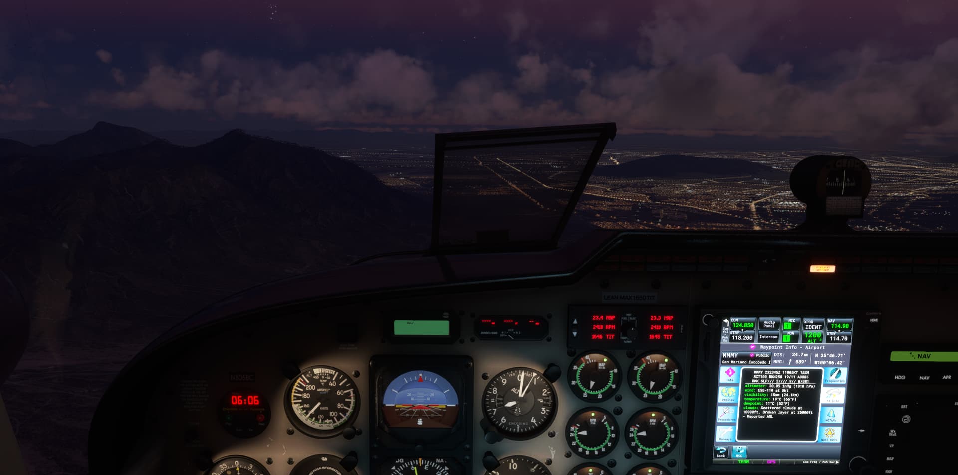
The field elevation at MMMY is 1,260 ft. The latest METAR is shown on the GTN750 in the screenshot. For ease of reference, here it is:
MMMY 232345Z 11005KT 15SM SCT100 BKN250 19/11 A3005 RMK SLP/// 5//// 9// 8/081
Scattered clouds were reported 10,000 ft. AGL. That should equate to 11,260 ft. above sea level (MSL). Instead, the cloud bases were near 7,000 ft MSL as shown in the screenshot.
Two other weather stations are located in the same region: Del Norte International (MMAN) and Plan de Guadalupe International (MMIO). The elevation at Del Norte is 1,474 ft. Here is the METAR from there:
MMAN 232340Z 14005KT 12SM BKN200 20/09 A3010 RMK SLP/// 5//// 9// 8/002 ISOL AC
No significant clouds in the 7,000 - 12,000 ft range were reported here (although the remark indicates isolated altocumulus clouds).
The field elevation at Plan de Guadalupe is 4,712 ft. Here is the METAR:
MMIO 240003Z RTD 36008KT 10SM SCT040 15/05 A3018 RMK 8/500
The cloud height above sea level would be 8,712 ft – still much higher than the 7,000 ft MSL cloud base shown in the screenshot.
Clearly, the clouds in the sim are being drawn too low, but this example suggests that a faulty conversion between AGL and MSL may not be the reason.
2 Likes
100% this is not the bug people thing it is, one just has to do simple research and simple maths to see it isn’t the case.
It’s much simpler than any kind of mix up between AGL and MSL, it is simply that the new system is a total mess and is broken, hasn’t been tested at all, and rushed out for no reason whatsoever.
3 Likes
Even before SU7, I frequently ran into clouds that were lower than METARs reported. I vividly remember taking off from Galveston, Texas (KGLS) on September 13th when Hurricane Nicholas was approaching. At the time, the METAR showed the lowest cloud layer was 8,500 ft:
KGLS 131952Z 11021G29KT 4SM -RA FEW085 OVC110 28/22 A2996 RMK AO2 PK WND 11031/1912 SLP146 P0008 T02780222
Unfortunately, I was in solid clouds only a few hundred feet above the ground after takeoff, and the next half hour, I was flying on instruments trying to get out of the storm. Area METARs were similar to the Galveston METAR – low clouds were not in the area at the time.
1 Like
Yes, because Metars were not used before SU7.
1 Like
did you ever got a hotfix in this year?
Nope you didnt get any hotfix!
Wait until next update
While I agree with the problem here, that something is up with the cloud bases, as others have said I don’t think it’s a MSL/AGL issue.
It’s probably a broader issue with drawing of clouds so perhaps the topic should be renamed as there’s a chance it may not get investigated properly or the developers will dismiss it as it stands.
3 Likes
Yep something like cloud base accuracy? Or along those lines would better describe the issue, whilst still allowing for investigation into whether there is any mileage in the AGL/MSL issue.
1 Like
Yeah I’ve got no live weather again now, think it’s another day to just forget about it
Yeah they should also have a simple rule programmed that ground clouds can’t exist when the dew point is lower than the temperature. Seems a simple thing to implement?
And when the dew point and temperature are equal at a certain humidity and under a certain altitude fog will form which looks different from clouds.
It seems they are not using dew point at all as a way to minimize impossible situations to happen.
2 Likes
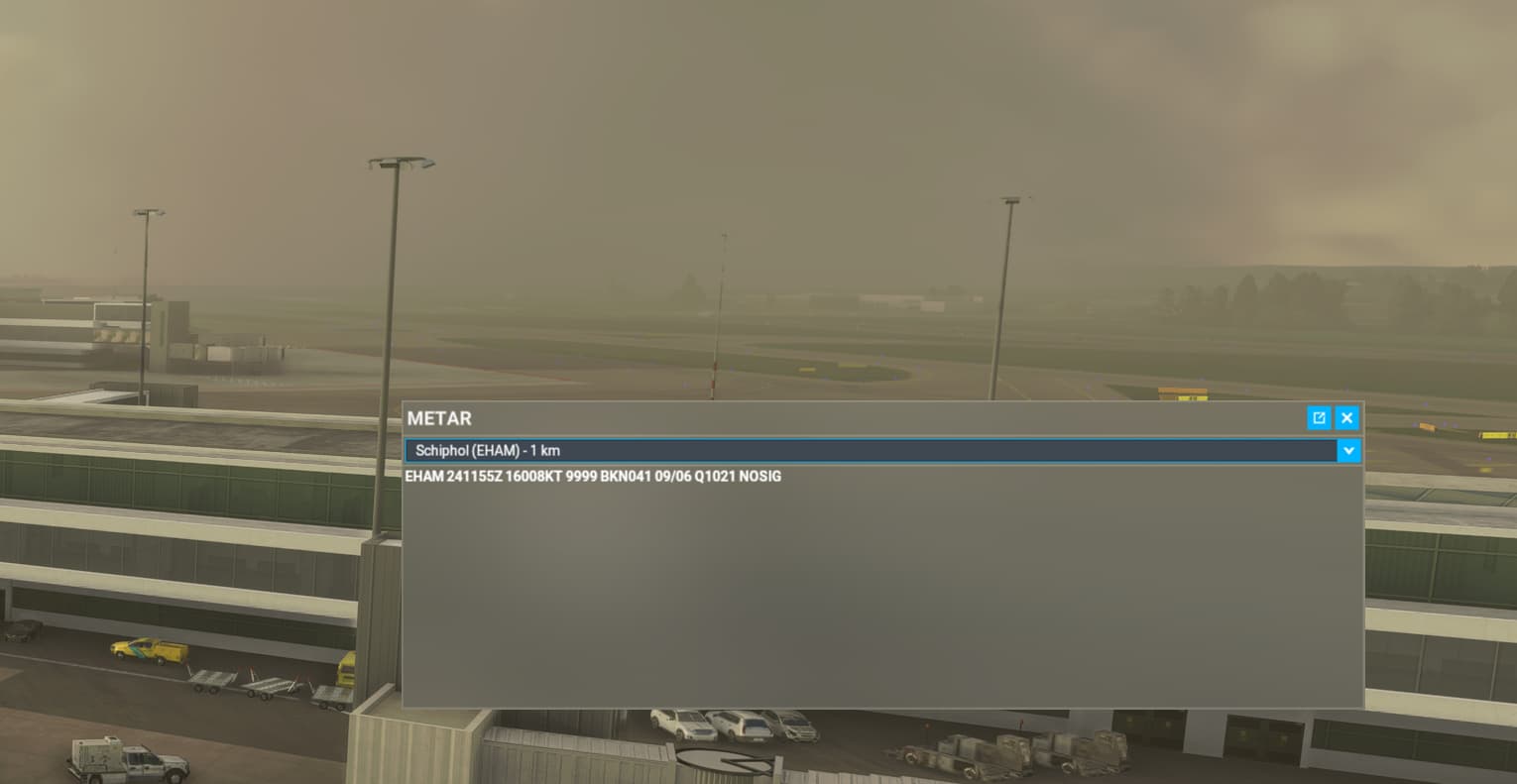
The sim is not usable like this, the weather is beautiful here IRL. The METAR is correct but the sim is just giving me ground clouds. Can’t do a normal landing if a cloud is on the runway. EHAM is under sea level by the way so MSL/AGL is not an issue.
Please Asobo give us a hotfix for this, we can’t fly seriously/on VATSIM currently.
5 Likes
If not a hotfix, please give us a sticky message at the top of the forum telling us what is going on. It would put a lot of people’s minds at rest.
7 Likes
Well i am grounded, it’s impossible to fly on VATSIM like this so a fix would be highly appreciated.
4 Likes
Confirm the cloud bug! Clouds are almost always on the ground everywhere on Earth! Please do something, you completely broke the game with U7, but who cares - now you can do the Reno racing, it’s the most important thing in MSFS allright 
2 Likes
hello. i have no clouds in my airport, but the METAR says its cloudy. So, there is a problem.
Yesterday was the opposite,very low clouds in one of canary island (wich was not true because i live here).
there is this bug and i understand something goes wrong.
thanks for fixing it. 
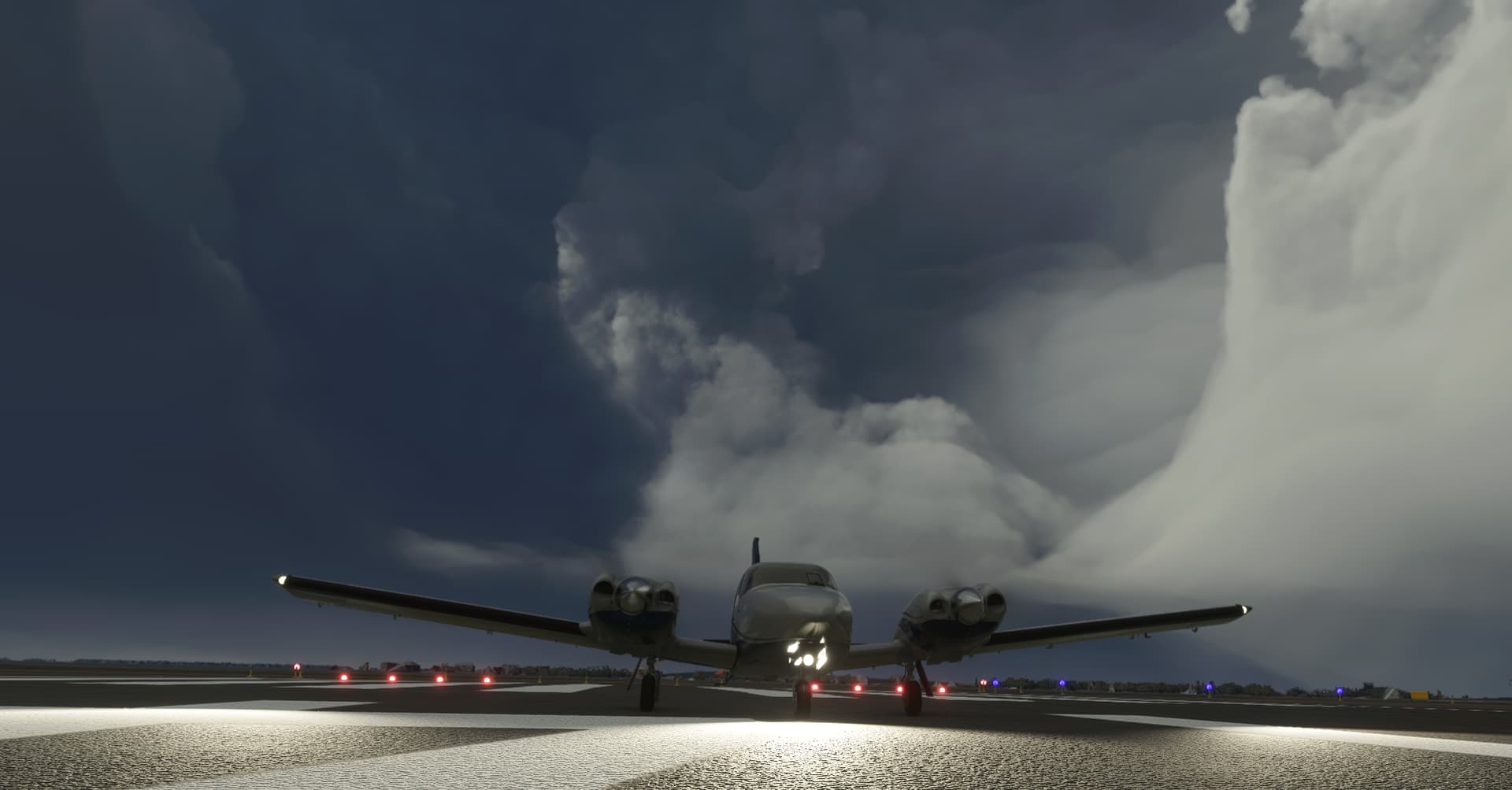
I ran into this towering cumulus “arch” cloud growing out of the ground just south of the Lago de Chapala near Guadalajara, Mexico two days ago:
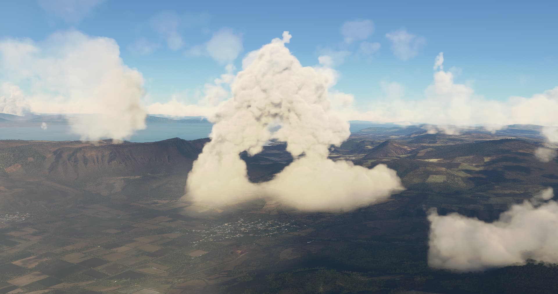
The METAR being read as MSL rather than AGL would be consistent with some of the odd clouds, fog, and haze I’ve been seeing since SU7.
It also happens at and under sea level (Ground clouds) so that would indicate it has nothing to do with a MSL and AGL mix up?
1 Like