*( I have to deal sometime with outdated data and some vor are not available anymore … I really hope to see aday a mod allowing old VOR to comeback alive).
not really a cheat sheet or the best data base as expected, sorry I don’t use navigraph, and don’t had the opportunity to try their new vfr feature probably someone will be able to give you some good hint to exploit its full potential
Thank you for reminding me about skyvector. It appears I can right click on a waypoint, click the “plan” button next to the waypoint name, then do the same on a nearby VOR and voila, the radial and distance (at least to the nearest nm) is shown.
I’ll try this method when planning the next flight!
This was already mentioned, but you can create a so-called “cheat sheet” yourself using LNM. You draw lines from any VOR and it will tell you the radial and distance to the end of that line which you can enter into the RNAV computer.
Actually it looks like you can create lines right in the SkyVector website to show distance/radials from a VOR (or any point). I’m doing an Alaska Tour with no GPS, just visual/VOR/ADF, and this’ll come in handy for a few routes.
In the old days, we used to draw a line on the sectional and measure the distance and angle, then use a clock to time the distance…
I got my license about 5 years before GPS’s became a thing… My first GPS was one of those little handheld Garmin things where you had to type in the nav coordinates of your waypoints, lol
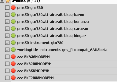
So, the B200 enhancement includes some PMS50 code, which is very likely overriding all the other code and, since everyone is complaining, is likely old code (in the html_ui directory). The first thing I would do is make sure all the PMS packages are installed so they occur after the enhancement code alphabetically.
The B36 doesn’t have this code.
When testing anything, always have to remove everything except that which is being tested. It’s the only way to narrow down where the problem is.
yeah yeah that is something I thought,in the doubt, unticked all enhancement panel
to clarify, my test were based with the following community folder
edit anyway just took a look, this may don’t really matter since BK200 is the only one to get the nav system folder with the folloing pms50_gtn750_int subfolder
I guess it may be superfluous, (as I don’t know what it’s purpose there) I will report that to ethel20092904
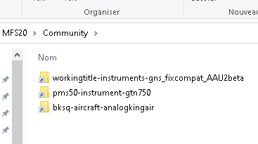
Today, I will test more rigorously and do things the way I should have done from the start. I will run with only the King Air and the simple GTN750 unit + the fix, ensuring that I’m not claiming something is an issue while it might actually be another mod interfering
edit 2 : I confirm the boot issue remain even with only the BS King air, GTN750, and the fix compatAAU2 into the community folder and using the GNS530 by WT
I just wonder if this plane’s behavior is realistic in terms of stopping distance.
In my opinion this plane stops way too fast fully loaded with reversers on.
I have read in the changelogs that this issue has been looked into, but still.
Europe is making an effort to move to Free Route Airspace areas - which removes huge amounts of RNAV waypoints. I was pretty surprised when most of my local waypoints vanished recently, a bit west of me there’s an area with absolotely none at all now. ( and practically all the GA traffic is following the coast now ). As was said you can use LNM which will snap the measurement tool to a particular thing ( VOR, airfield, waypoint etc ), so you can plot the entire route by drawing lines from VORs to intersecting points. Frankly I don’t bother & just go between VORs anyway but I’ve plotted my way round an RNAV arrival via intersecting radials before, which makes life very busy. I suspect LNM can probably put circles around points too, but I’ve never explored that.
Yes, this is the method I use and it works fine. Little Navmap gives also a great quantity of information about all kind of navaids, airports, obstacles and so on. I also have Navigraph and I use it just for filghts over FL 190 and for STAR and APP charts.
Part of the fun when I fly is finding a waypoint to use RNAV in case that no other method is available. I’ve discovered RNAV through the KNS-80 included in Black Square’s planes, I had not used it before.
My question is: is there any way to use RNAV with Garmin equipment (750, 530, G1000, G3000)? I would like to use this technique with other planes that do not have a KNS-80 installed.
I believe the G3000 allows you to create a Custom Waypoint ,but I’ve never actually tried it. I’m pretty sure it can be entered via lat/long, but unsure if you can base it off a VOR radial/distance. I might check this out tomorrow.
Waypoint Info, Create waypoint, can do four types: RAD/DIS, RAD/RAD, LAT/LON and P.POS. RAD/RAD is two VOR stations, where their radials intersect. Sadly it doesn’t seem to save User Waypoints between flights.
You can usually add a fix as a distance/radial from another point ( which if it’s a VOR makes life very simple ) in most GPS units.
Actual RNAV with garmin equipment is simply making a flight plan & adding the waypoint names as intermediate points, no messing about with VOR radials. If you want to add your own - ie, not published - waypoints to the plan, enter them as a fix & save them with a memorable name, then they’re just like any other RNAV waypoint.
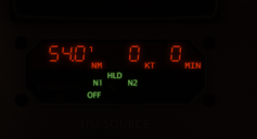
I’m seeing this too…DME shows the distance counting down, but no KT or MIN for both NAV1 and NAV2. Seeing this in the Bonanza as well. Any ideas? Not critical, but nice-to-have for a no-GPS Alaska tour I’m doing.
KNS 80 usually provide those data when the dme don’t
I also have this, suspecting this to happen when flying outbound, maybe the dme unit is unable to comput its data (in earlier version dme was sometime displaying some large number, like 9999 or -9999 those issue has been fixed and now we got a 0 I guess )
Thanks, @VanDisaster , but I’d like to navigate using NAV radios, not GPS. Garmin equipment can be used with VOR so I wonder if I can use a Garmin to navigate to a point created by me “moving” a VOR just like a KNS-80 does.
Another interesting semi-bug. If you do have distance/speed/time displaying correctly, and you increase the Sim Speed to say 2x, then the projected time to the next waypoint doubles, and the calculated speed gets cut in half. Not sure when happens when you up the sim speed to some significant percentage of the speed of light.