Here is a custom GPS approach with LNAV/VNAV to L18 in the US. GitHub - Normfly/MSFS2020-custom-LNAV-VNAV-approach-L18: A custom LNAV/VNAV approach for L18 (fallbrook CA, USA)
<?xml version="1.0" encoding="utf-8"?>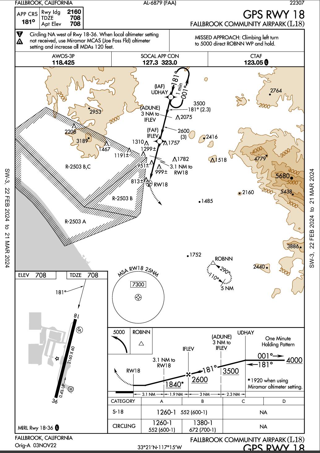
 <Waypoint lat="33.43800278" lon="-117.22564167" waypointType="FAF" magvar="11.1" waypointRegion="K1" waypointIdent="IFLEV"> </Waypoint>

 <Waypoint lat="33.4076" lon="-117.2346" waypointType="NAMED" magvar="11.1" waypointRegion="K1" waypointIdent="31RW"> </Waypoint>
<Airport name=“Fallbrook Community”
       lat="33.35415154695511"

       lon="-117.25085869431496"

       alt="214.426M"

       ident="L18"

       trafficScalar="1"

       isOnTIN="FALSE"

       onlyAddIfReplace="FALSE"

       applyFlatten="FALSE"

       starAirport="FALSE"

       closed="FALSE">


<DeleteAirport deleteAllApproaches="TRUE" />


 <Approach type="GPS"

      runway="18"

      designator="NONE"

      gpsOverlay="FALSE"

      fixType="WAYPOINT"

      fixRegion="K1"

      fixIdent="IFLEV"

      altitude="2600F"

      heading="181"

      missedAltitude="5000F"

      lnav="TRUE"

      lnavvnav="TRUE"

      lpv="FALSE"

      lp="FALSE">


      <ApproachLegs>

           <Leg type="IF"

                fixType="WAYPOINT"

                fixRegion="K1"

                fixIdent="IFLEV"

                altitudeDescriptor="+"

                altitude1="2600F"

                isFAF="TRUE" />


           <Leg type="TF"

                fixType="WAYPOINT"

                fixRegion="K1"

                magneticCourse="181"

                altitudeDescriptor="+"

                altitude1="1840F"

                fixIdent="31RW" />


           <Leg type="TF"

                fixType="RUNWAY"

                fixRegion="K1"

                fixIdent="RW18"

                magneticCourse="181"

                altitudeDescriptor="A"

                altitude1="753F"

                verticalAngle="3.50"

                flyOver="TRUE"

                isMAP="TRUE" />

      </ApproachLegs>


      <MissedApproachLegs>

           <!-- 1. Climb on runway heading to 1200ft first (Standard Procedure) -->

           <Leg type="VA"

                magneticCourse="181"

                altitudeDescriptor="+"

                altitude1="1200F" />


           <!-- 2. THEN turn direct to ROBNN -->

           <Leg type="DF"

                fixType="WAYPOINT"

                fixRegion="K1"

                fixIdent="ROBNN"

                flyOver="TRUE"

                altitudeDescriptor="+"

                altitude1="5000F" />


           <!-- 3. Hold at ROBNN -->

           <Leg type="HM"

                fixType="WAYPOINT"

                fixRegion="K1"

                fixIdent="ROBNN"

                magneticCourse="290"

                turnDirection="L"

                time="1.0"

                altitudeDescriptor="A"

                altitude1="5000F" />

      </MissedApproachLegs>


      <Transition transitionType="FULL"

           fixType="WAYPOINT"

           fixRegion="K1"

           fixIdent="UDHAY"

           name="UDHAY">

           <TransitionLegs>


                <Leg type="IF"

                     fixType="WAYPOINT"

                     fixRegion="K1"

                     fixIdent="UDHAY"

                     altitudeDescriptor="A"

                     altitude1="4000F" />


                <!-- Racetrack course reversal -->

                <Leg type="HF"

                     fixType="WAYPOINT"

                     fixRegion="K1"

                     fixIdent="UDHAY"

                     magneticCourse="181"

                     turnDirection="L"

                     time="1.0"

                     altitudeDescriptor="A"

                     altitude1="4000F" />


                <Leg type="TF"

                     fixType="WAYPOINT"

                     fixRegion="K1"

                     fixIdent="ADUNE"

                     magneticCourse="181"

                     altitudeDescriptor="+"

                     altitude1="3500F" />


                <Leg type="TF"

                     fixType="WAYPOINT"

                     fixRegion="K1"

                     fixIdent="IFLEV"

                     magneticCourse="181"

                     altitudeDescriptor="+"

                     altitude1="2600F" />

           </TransitionLegs>

      </Transition>


 </Approach>
The github links explain how to develop and/or change L18. But, basically enabling developer mode - create a airport scenery project and add this xml in the C:\MyFSProjects\L18_GPS_18\PackageSources\Scenery\airport-l18-fallbrook\scenery\ folder. - then build
To make the sim recognize create a folder in the community folder with the json files and the scenery folder with the .bgl file.
The default for this airplane in the sim did not support GP or VNAV below the FAF and the APR button would not arm. Now, you just hit the APR button and a lower altitude selected and GP will activate to the threshold. Pretty close to the real thing.
I hope this helps someone. There was not a lot of info out there.