One of my model aero club members has sent me this Chart. He says if I am going to do leisure/photo trips in this area then I should comply with these charts with regard to altitude. He said a “proper pilot” would have already studied these … ![]() I hope AI ATC does not tell me to disregard the chart. Point taken buddy!
I hope AI ATC does not tell me to disregard the chart. Point taken buddy!
hey. Which chart?
Sorry, It will not allow pdf files apparently. I may delete this post.
Just fly the way you want to.
If you just want to go sightseeing, you can ignore all the rules, it’s a sim after all.
If you want to emulate a real pilot, feel free to follow all the charts / rules / books.
That’s the nice thing about a sim, you can enjoy it however you like.
I brought this up as I posted a video of my flight from EGHH to Bembridge IOW then on to Southhampton. A member (ex ATC) of my model flying club mentioned about the height I was flying at overall. Did the AI ATC tell me this? That was a good point, does the AI actually use real charts? Yes it is a SIM and you can fly anywhere in the World now but the real fun starts when you become a proper armchair pilot… ![]()
Current ATC is basic. If you ask for clearance through an airspace you will always get it, without instructions on altitude or course.
If you want to follow the rules, you’ll have to plan accordingly yourself. The current ATC will do nothing to assist in that.
Thanks for that info. Saves me testing ATC. Although time will tell as this Sim is still very new.
Haha, if all we simmers got a letter or visit from the CAA/FAA every time we encroached controlled airspace ![]()
I have a 20 year old chart of the Southern UK and that’s about it. Most of the time, I fly where I want and at the altitude I want. other than checking the SIDs and STARs when compiling a flightplan, that’s about it.
Do you understand the chart?
Check out, this site for more info (by that I mean tons of it):-
I think one of the glaring omissions in the sim is that the MFD/Nav screens do NOT show airspace, just waypoints and the route.
In real aviation even much older GPS systems show airspace, and in fact give (irritating) repetitive warnings of proximity to airspace entry.
I think this could lead the mass of non aviation trained users of the sim to believe you just fly from A to B without consideration of having to avoid airspace or negotiate a crossing if you can’t go around or over/under it.
I know the Planning globe has an option to show airspace, but it is switched off by default!
The VFR map doesn’t show airspace either.
So what your saying is for non aviation trained Sim users adding that capability would in effect make the Sim so complicated that it would lose it’s appeal and want even more memory space. I avoid the use of the word “Game” because I consider the Sim is what it is. What I will do more for my benefit is plan a flight and make AI ATC requests whilst in the Charts area to make it more “interesting” a trip.
The thing is you do not go into the control spaces without permission.
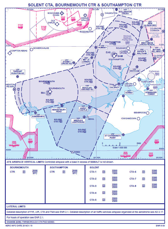
Take a look at the above chart around Bournemouth, it is Class D from the surface. No entry without ATC giving permission.
The VRP at Stoney Cross, flying from there SE to the Isle of Weight as long as you are less than 2000 feet you can fly the route.
The other areas bordered by the red hatch is a Military Zone where you most definitely do not want to go.
BTW
It may be called Flight Simulation but in reality is a very loose approximation.