Flying Round The World in a C208 - Monty's Trip

Awesome Steve!

It’s looking like my main pinch point is hopping from New Zealand to South America without changing planes There is a gap to Easter Island which is just way too big.

Do you have your route saved anywhere?

Monty

Oh try the lot out, different aircraft every leg. Why deprive yourself?

I’m a big fan of the Pipistrel, it’s got such great visibility to the sides. The Icon A5 is a joy to fly as well.

And you’ll be very hard pushed to find a GA aircraft that can make that leg. Most round the world trips come at New Zealand from Australia and then leave north bound up the Solomans, The Philippines, Japan and round the north to the Bering straights.

If you come down from Singapore and head clean across Australia for Tasmania, cross the Tasmanian sea there to New Zealands south island, that’s the shortest point. Then turn left and you’re on the homeward trip.

Glad it helped a bit. My route is up to date. I have a busy day tomorrow so I might not get to fly the next leg tonight, but I try and make some progress most nights.

South America is turning out to be quite an epic undertaking… There’s so much here that it’s going to take me a good while to reach Cape Horn and then back up the West half of the continent, with all the volcanoes and coastal/mountain cities. I’m considering a return trip to Antarctica too.

Will you be logging your trip do you think?

I’m thinking Africa is going to be like that too!

Ya I will be logging it like you, going to use google maps as well!

That’s why I was going to ask if you wanted to join a discord server. Would be easier to keep tabs on each other that way, and have other’s join if they are doing round the world trips!

Let me know what you think!

So many great posts here, and welcome to the round the world gang! I’ve just finished Leg 52, over 56,000Nm so far and 215 flying hours. I’ve capturing it all on a thread and taking a LOT of pictures as I go - over 3,000 so far.

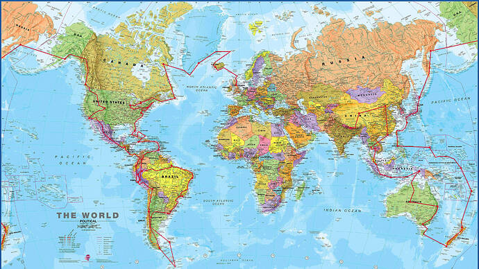
I didn’t start out very well planned - just headed off in the TBM to see where I would end up. I picked the TBM because it has good range and reasonable speed, seems easy enough to fly and I can bob along at a couple of thousand feet if I want but also make it over the highest mountains. My route has been very circuitous:

So I’m probably barely half way - still got all of Africa and Europe to do as well as the Middle East and a fair part of Western Aisa/Eastern Europe.

I thinkt the key thing is to make sure it doesn’t become a chore. So I fly when I have time, not to a schedule. I’m also not too strict on the realism front. I don’t start cold and dark, and I don’t always park at the gate. I’ve often picked small airports to land at - only to find there is no fuel facilities…

For me the flying and sight seeing is the fun part - but you’re experienced in the flying bit, so other aspects may appeal.

I agree with everything @EddieSimes says in his post too and echo a lot of his thinking.

Personally I plan my flights in a number of different ways, depending on how I feel. I sometimes use Little Nav Map for planning (I always use it as a moving map, as it is great for tracking exactly where you are and being able to find/recognise areas you are flying over or identify rivers, cities etc as you are flying). Sometimes I use the MSFS world map - especially if I want to tour around some of the POIs - I then import the flight plan into LNM to follow along. I sometimes use VFR, sometimes low altitude IFR and (especially long hauls over water) high altitude IFR. I often use the world map as a starting point, then look for interesting airports or POIs to divert over.

Half the fun is not really knowing where you will go next. I took a detour to Antartica from the Falklands…and nearly didn’t make it back!

On whim I decided to follow the Amazon from its source to the Atlantic - it was really interesting finding and researching the source, then actually figuring out how to get there.

I’ve been planning my next RTW tour for a while actually. The next one will be to visit all 227 capital cities (or at least their airports) in as efficient a way as possible. I’m very interested in @DrinkingGuide84 's post where he links to a tool that can optimise the route. I’ve been programming an optimiser in Excel (something to do in the cruise!) and have managed to get my planned tour down to about 110,000Nm. This trip will need something like the Longitude because one of the legs is from Mexico City to Papeet in French Polynesia - 4,277Nm. However DrinkingGuide84 may have already done this for me! I’m off to check that out now.

In the meantime - above all - have fun and enjoy it. Don’t make it feel like work - oh, and remember to keep a log!
5 Likes

Your first post read OK but then you showed a Caravan above the clouds.

Where is the fun in that?

VFR down below 3000 feet AGL is the way to go and minimise boring time over water.

As for aircraft, whatever you have that runs well and fast on your computer and as long as it has IFR capabilities and GPS is all you need.

Be sure to go via routing where the best MSFS graphics are.

1 Like

Antartica is a real challenge - I couldn’t find an airport or airstrip there, and hence needed to do a flyby - even in the TBM I only just made it back - ran out of fuel on final approach!

1 Like

Thanks Gordon! Some great tips again! Also, I love the route you have there! Where did you actually start from?

I will take a look at your thread!

Also, how do you take your pictures? I think print screen is the best way, but it doesn’t seem to be working for me! Share some of your favs if you don’t mind!

Monty

Ughhhh I know haha, thanks Biggles for the comment.

This I think was one of the key tips I needed to hear from everyone. Do the trip low, and as VFR as possible.

To be fair, I fly southern Ontario in real life, and the live weather at the time was OVC 1000-8000, so I kind of had to get above, but from now on I’m not going over 3000 AGL ha.

Is there a resource you suggest for the best graphics areas? I am new to FS2020, so dont know all the ins and outs yet.

I started in my home city of Edinburgh in Scotland. Headed North to Iceland and pretty much turned left :grin:

I use print screen. By default this saves the screenshot in your documents/pictures/screenshots folder I think. If you have multi monitors, you need to make sure to click on the flight sim monitor and then press ALT+PRT-SCRN so that you only get the “active monitor”. Otherwise, just pressing PRT-SCRN will capture both monitors (or all 3!) at once which is a pain.

I’ve got so many good ones to choose from, but here are some of my favourites…


Sorry! Once I got started, I couldn’t stop! That last one is where I am currently - Lukla near Everest.

10 Likes

No worries its great to share, brilliant nice to see such a positive Post about MSFS kerp it up you guys planning on your world tours :clap::clap:

1 Like

My only advice and top tip make sure you have enough fuel

1 Like

This is awesome! I’m going to have to get the camera out! Appreciate this! It really is inspiring to see! Did you use any special scenery for your trip?

Thanks! Also glad to see there are some crazies like me having fun doing the low and slow around the world!

Monty

3/7/21 - Air Time - 2.2

Hey @EddieSimes @SwoopGB @gordongreig @DrinkingGuide84 @Biggles1950 @JWATTS0275

Happy to report I completed Leg 2 CYUL Montreal to CYFC Fredericton. I used all of your advice. Stayed low, just flew VFR with the heading bug, and took in the sites.

Went over downtown Montreal, and then east across the St Lawrence River to Quebec City. Then took a right turn down to Mt Katahdin in Baxter State Park. Continued east to Fredericton and took in the snowy surroundings.

Unfortunately didn’t have MTL CTR, but got BOS and Moncton on VATSIM.

Not quite at @gordongreig level, but here are some photo’s!
Montreal downtown

Trois Rivières

Quebec City

Mount Katahdin

Fredericton

Hope your trips are going well! Please share your photo’s and legs! And if you really want to stay connected I can create a Discord server for us to put everything into!

Monty

1 Like

I’m going west to east as well. I don’t have much money like some people, so I can’t afford to buy a new plane every time I want to skip over some boring part like water or desert. I’m flying an XCub and plan on touching wheels to every country I possibly can. So far I’ve landed in 81 countries, logged almost 180 hrs, and flown over 20,000 miles. I’ve never increased sim rate or added fuel mid-air. I’ve flown VFR in live weather exclusively. When I’ve crashed from my own mistakes, I’ve re-flown the entire leg. I’ve flown one livery, and I will return home in exactly the same aircraft that I left in. I know I’m going to get spanked for this, but any other method of flying around the world feels like cheating. To each their own, I guess.

2 Likes

:grin: Hardcore. I love it!

1 Like

Thanks, and your pics are a great start. Don’t blame me when you’ve filled your hard drive though!

I’ve only bought a few scenery add ons so far - London City (although currently doesn’t work with the new photogrammetry - although they are fixing this), Sydney, Hong Kong, Seoul, Shanghai and Singapore. Everything else is standard. I’m not rushing to buy any more scenery, and as I’m flying to all different airports all the time, I don’t see value in buying airports - but that’s just me. If there was an Edinburgh one through the marketplace I’d buy that, just because I know it well and the control tower is quite cool in real life.

Much of the beauty of this sim is going off the beaten track though - pick a random airfield you’ve never heard of and see what you find :grin:

2 Likes

I love it! I need to take something a bit quicker, but doing the same as you. Taking my Caravan for the whole trip!

Are you keeping track of your route somewhere?

Monty

1 Like