Version 0.7.3:
- Added DME to both ILS definitions with a range of 30NM.
- Moved ILS with GS/DME under the runway definition.
- Enabled the ILS backcourse on both ILS runways.
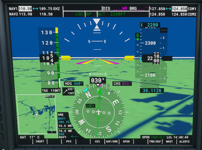
DME working, giving you a distance to the DME antenna (~touchdown)
Runway ILS showing up on the map with DME capabilities
In my test landing, auto approach, I had a touchdown with approx 0.1NM left on the DME reading.
<Runway>
    <Vasi end="PRIMARY" ..."/>
    <Vasi end="SECONDARY" ..."/>
    <Ils lat="51.462503" lon="5.388386" alt="73.3F" heading="34.99" frequency="109.750" end="PRIMARY" magvar="1.0" ident="EHZ" width="5.0" name="LOC 03" backCourse="TRUE">
        <GlideSlope lat="51.442828" lon="5.368433" alt="8.229M" pitch="3"/>
        <Dme lat="51.442828" lon="5.368433" alt="108.229M" range="30N"/>
    </Ils>
    <Ils lat="51.437525" lon="5.360386" alt="66.6F" heading="215.01" frequency="109.750" end="SECONDARY" magvar="1.0" ident="EHO" width="5.0" name="LOC 21" backCourse="TRUE">
        <GlideSlope lat="51.456194" lon="5.383767" alt="8.229M" pitch="3"/>
        <Dme lat="51.456194" lon="5.383767" alt="108.229M" range="30N"/>
    </Ils>
    <RunwayStart end="PRIMARY" .../>
    <RunwayStart end="SECONDARY" .../>
</Runway>
ILS definition must be placed between the Vasi and RunwayStart definitions.
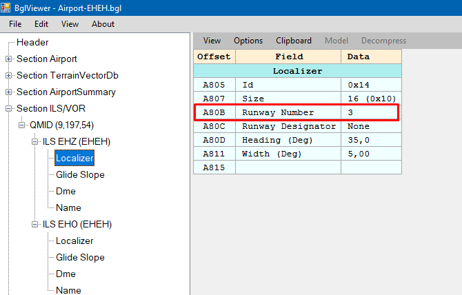
BglViewer now shows that the runway localizer has the runway number defined
@MJetten Try the ILS def inside the Runway def and see if that would help with your ILS approach definitions and planning an ILS approach, as you mentioned it would crash for you or something?