Is this what its supposed to be doing?
EDIT:
Yes, that fixed it! well done OCgineer!
Swapping the glidescope in your code mentioned above made it work!
EDIT:
Yes, that fixed it! well done OCgineer!
Swapping the glidescope in your code mentioned above made it work!
Hmm, coming from the NorthEast, locked on EHO which is good and it seems you are just above the glide slope now? Not sure about this aircraft, so far I have only flown the Cessna 172 with the G1000.
Edit; well that is good. Though then the heading needs to be in the same direction as the approach heading as I assume you haven’t changed anything else. I wonder what happens if I swap the heading, going to try this for science.
@MJetten where was your touchdown point? At the PAPI?
it would have If I didn’t turn off AP and accidentally went into full thrust mode 
But yeah, would have landed at the PAPI lights.
Edit: I previously had the heading the other way around (last week) and i remember when clicking on the LOC it would just have the airplane go into a full 180 and fly the other way.
So I guess your heading, at least in terms of code is fine.
Last but not least, my ILS is at a slightly different location:
<Ils lat="51.46264214643296" lon="5.38847719873592" alt="16" heading="35" frequency="109.750" magvar="0.0" ident="EHZ" width="5.0" name="ILS 03">
        		<GlideSlope lat="51.442828" lon="5.368433" alt="8.229M" pitch="3" />
		</Ils>
		<Ils lat="51.43754817602908" lon="5.36035286546155" alt="16" heading="215" frequency="109.750" magvar="0.0" ident="EHO" width="5.01" name="ILS 21">
			<GlideSlope lat="51.456194" lon="5.383767" alt="8.229M" pitch="3" />
But its using your location for the glideslope.
For my ILS is placed a scenery ingame and used the gizmo to get the location
(still need to replace it with something better)
Than that did the trick yeah. Perfect!
@MJetten You need to reduce the initial offset of the approach lights so it doesn’t go over the auto way. I have noticed with the satellite images and the plans that the offset of the first light is not 34 meters but more around 10 meters. Though this depends as well on what the extra pavement is of the runway that you set. I make use of the same in-game asset of the antenna’s and placed them on the exact same spot as I put in the ILS code (just edited the xml directly).
I have seen somewhere, can’t find the source, that the extra pavement is 800 feet (243.84 meters) for both sides.
I just noticed something regarding the heading, and that’s that Backcourse is also flagged. So that makes sense that the plane is on correct heading while the code is 180 off. Don’t know where to change that, if needed at all. My understanding of ILS is that the Backcourse signal is the correct signal, and the ‘Backcourse’ approach reverses that again
If you get the backcourse signal while approaching then the two heading numbers need to be swapped, as I was about to do and test! This is with the swapped glideslopes and heading.
Edit, ok so the headings were correct and need to be set to the same heading as the approach heading. If swapped around, you get in the back course with the arrow pointing away from the runway.
I think I actually have 2 different “extra pavement” on each side, 240m and 250m
Thanks for the headsup on the lights.
I might even be using the wrong set up.
Also, this one might be interesting for you:
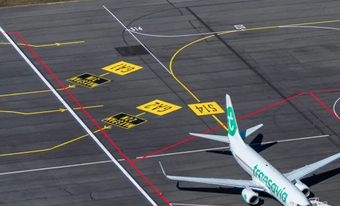
It looks like they did quite a lot of stuff on the apron, they moved the service road behind the airplanes further back.
And the yellow line doesn’t have the “curve” at S11 anymore but is now a straight line
They made use of that extra spot and made it S14!
OOF even more

2 General Aviation parking spots, max wing span of 22 meters.
Wow it changed a lot since last time I was there. But that was a diversion. I usually fly out of EHAM or EHRD
Yup, and you can still see the old road:
Hopefully the link helps 
In my few weeks doing research on EHEH to create the custom buildings, it’s interesting to see how much everything changes year to year
(for example the terminal changed at least 4 times, from adding a section, to closing parts of the roof)
Also gotta love this;

vs

Spend ■■■■ to much time on EHEH LOL
Yup got mine working as well properly in version 0.7.2.
Version 0.7.2 is released now, find the link in the first post as usual.
Automated approach and looking at the PAPI lights it is right on! Though in the end it went a bit too low and I felt it flaired (if it even did so) a bit hight, so might need to finetune later.
Version 0.7.3:

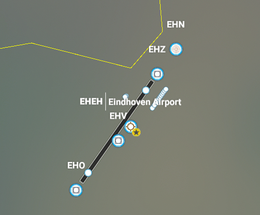
Runway ILS showing up on the map with DME capabilities
In my test landing, auto approach, I had a touchdown with approx 0.1NM left on the DME reading.
<Runway>
    <Vasi end="PRIMARY" ..."/>
    <Vasi end="SECONDARY" ..."/>
    <Ils lat="51.462503" lon="5.388386" alt="73.3F" heading="34.99" frequency="109.750" end="PRIMARY" magvar="1.0" ident="EHZ" width="5.0" name="LOC 03" backCourse="TRUE">
        <GlideSlope lat="51.442828" lon="5.368433" alt="8.229M" pitch="3"/>
        <Dme lat="51.442828" lon="5.368433" alt="108.229M" range="30N"/>
    </Ils>
    <Ils lat="51.437525" lon="5.360386" alt="66.6F" heading="215.01" frequency="109.750" end="SECONDARY" magvar="1.0" ident="EHO" width="5.0" name="LOC 21" backCourse="TRUE">
        <GlideSlope lat="51.456194" lon="5.383767" alt="8.229M" pitch="3"/>
        <Dme lat="51.456194" lon="5.383767" alt="108.229M" range="30N"/>
    </Ils>
    <RunwayStart end="PRIMARY" .../>
    <RunwayStart end="SECONDARY" .../>
</Runway>
ILS definition must be placed between the Vasi and RunwayStart definitions.

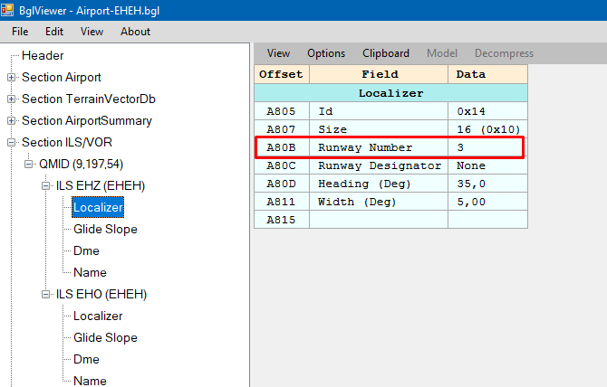
BglViewer now shows that the runway localizer has the runway number defined
@MJetten Try the ILS def inside the Runway def and see if that would help with your ILS approach definitions and planning an ILS approach, as you mentioned it would crash for you or something?
Yesterday I did a flight to Eindhoven in the A320, and in the MCDU I tried selecting 21 or 03, but available runways were empty. Only by entering the frequency of the ILS gave me guidance. Since the frequency of 21/03 is the same; if you enter course + frequency in the NAV/RAD page, is that sufficient for the Airbus to find the correct approach??
I am not sure, but you can see what you get now in version 0.7.3 (released like an hour ago) as the ILS should be linked to the runway now. However, there are no “waypoints”, “ApproachLegs”, and “MissedApproachLegs” implemented yet on my version as we are still working on those and I do not know if they are needed for the MCDU.
But ye if you could try out version 0.7.3 and see if you notice any differences versus version 0.7.2.
Unfortunately it didn’t prevent the game from crashing I’m afraid.
However I’m pretty confident it did help in the right direction!
(it took me a long time to get your part of the code right, ended up being me writing ILs instead of Ils)
So I guess I’m doing something else wrong with that ILS approach code
Thanks anyway!!
Edit: it’s a ■■■■ shame it just crashes it when I select it on the map… would be great if it just sends something in the console showing whats wrong
edit 2: haha, “d a m n” gets censored
edit 3:
I think your Dme code added the part in the left corner, nice work 