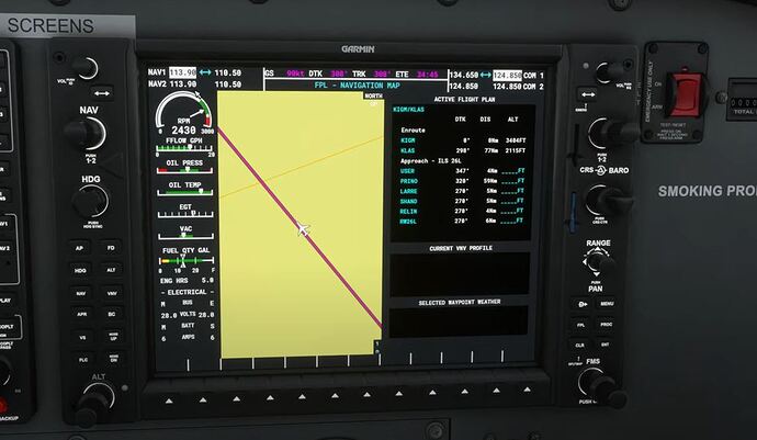
I have attached a screenshot of the G1000 and it shows a list of Waypoints such as USER, PRIMO, and LARRE and more.
After each one is a heading, then a distance and then ______ FT which is the point of this Topic. These are obviously an Altitudes.
But what are they for, how do I use them, how do I change them???
Thanks
Did you ever see an approach chart for an airport? They usually contain minimum altitude listings for the waypoints. Those are the values you might want to enter here so that you know what altitude you should be at when you arrive at the waypoints.
I don’t use this feature but I think if you click the FMS button you will get a white-flashing cursor in the window. Then you can rotate the big knob on the FMS button to move that cursor into position. Then the small knob would allow you to enter values.
The stock G1000 doesn’t have that functionality to have altitudes. This is a limitation of the internal nav system in the simulator atm.
If you want the altitudes, you can look at charts, or you can use the (free) G1000 NXi from the marketplace.
Approach Plate for KLAS ILS 26L
Section 2.3 talks about the Vertical Profile. In essence you must be at or below the altitude fixes specified at each waypoint (although IRL being materially below the fix could mean injury or death depending on obstacle clearance). This is the information missing from your FPL screen.
In the stock G1000, you must manually fly to that altitude. In the G1000 NXi from Working Title available for free from the Marketplace, the autopilot can descend you to those altitudes (VNAV mode), although in most planes, you must manage throttle to make sure your descent rate is supported by your speed over ground.
Watch this tutorial, it will, I am sure answer your question and get you going with VNAV.
This guy also has many very good tutorials.
Considering he’s using the stock G1000, this may be of limited use to him unless he upgrades to the NXi as per my previous post.
Hi Crunchmeister71, the G1000 NXi looks very good so far. It fills in the altitudes automatically.
Stay tuned. Going flying nnow to try it.
Cheers
Thanks for your note.
This topic was automatically closed 30 days after the last reply. New replies are no longer allowed.

