Zendesk ticket #128346
Version 1.19.9.0
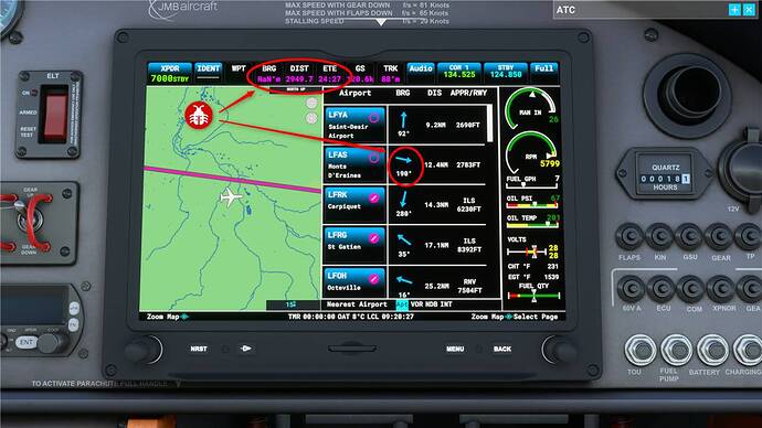
When selecting a nearest airport and activate the direct to function, the datas displayed on the G3X top line are inconsistent (VL-3 aircraft).
BRG clearly show “NaN” that mean NOT A NUMBER !!!
Distance and ETE are complety wrong.
The direction (heading) to nearest airport is also a total mess.
Ie: While flying over Normandy, I choose NRST to LFAS airstrip, located east from my position. The BRG indicate “NaN”, the distance is … er , sure I need more fuel!
And even the direction displayed in the airport list is wrong.
As you can see, the aircraft is heading east, the line is well displayed (the LFAS is on the right). Er, what? heading 190° ??? Sure, don’t use that if you are lost 
Are you on Steam or Microsoft Store version?
Store
Are you using Developer Mode or made changes in it?
No
Brief description of the issue:
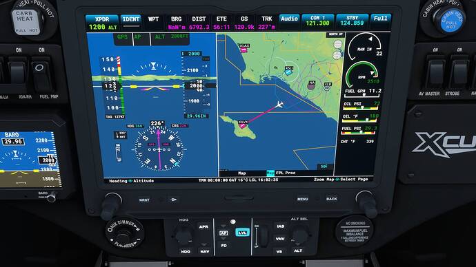
Exactly how far away am I???
Provide Screenshot(s)/video(s) of the issue encountered:
Detail steps to reproduce the issue encountered:
Started at KSNA and headed to KAVX. Started with -D-> on the ramp, then used the Nearest Waypoint function en-route. No change in Distance or ETE. Actual distance runway to runway is about 32 NM.
PC specs and/or peripheral set up of relevant:
In profile
Build Version # when you first started experiencing this issue:
1.19.9.0
Hi,
I’ve previously reported this bug (or a similar) in Zendesk #128346 (and I’m probably not the one thas has done it). I noticed this bug on Xbox version, so it’s not specific to PC.
The Direct-To display esoterics values, and if you look at the top, it’s written “NaN” (or Not A Number !).
This issue should be solved in the coming SU6. Take a look at the RELEASE NOTES 1.20.5.0, there are lines about this in the Avionics section:
- “G3X no longer show NaN bearing when flying a DirectTo toward an airport”
- “Fixed incorrect values for Bearing (BRG) and Distance (DIST) data fields on G3X”
So, we can expect a correct distance soon in the G3X  .
.
Thanks! I guess I missed that part. I haven’t flown the XCub in so long, I didn’t remember it being off the last time.
This Bug was fixed by Sim Update 6.
![]()

