Can someone please explain how to interpret the altitudes of the planes shown on the screen.
Is the altitude shown on the garmin 3000 TRAFFIC MAP PANE AGL/MSL or is it relative to my aircraft?
Also some examples of the actual numbers:
159=?
059=?
59=?
5=?
The way altitude is described by what I’ve read is xxx:
first x =10,000s second x =1,000s third x =100s
so 18500 =185.
Does this work for all altitudes starting from 100’ to 60,000’+ ?
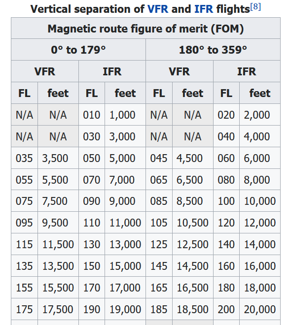
The chart you posted is for FAA ATC nomenclature regarding altitude calls made over the radio and on written documentation regarding flight planning.
The Garmin’s readouts do not correspond to that chart, probably for purposes of programming and font size/readability. A typical TCAS in crowded airspace would have many more targets displayed. Given that it’s primarily to call out potential hazards of collision, the investment would be in color-coding to give the pilot an immediate sense of where the other planes are vertically, then provide target information to specifically state how close they might be to inform any potential escape maneuvers.
It makes no sense to read out a target’s absolute altitude from the ground, either radar or barometric. What you’re concerned about with TCAS is how close is that aircraft to you, relative to your altitude (i.e., 500 feet above vs 2500 feet above is a big difference), what is their relative bearing and movement to you - behind, ahead, parallel, crossing, closing, opening, descending, climbing?, are they even reporting altitude (some do not) - so that you can make an informed decision about whether your path and their path in conjunction with altitude differences is going to come close to a collision. Then rules of escape maneuvers come into play so you don’t collide by opening up distances.
Excellent info thanks, and yes I do set my parameters to relative for collision purposes.
What I need clarification on is this nomenclature [whether above 18000’ of below transition altitude]:
18500’=185
8500’=085
500’=005
Is this supposed to be how I interpret the collision radar given altitudes because they are not always showing 3 digits?
Given that they provide examples where a two digit leading 0 is under 1000’ feet - i.e., -03 is 300’ below, 85 would be 8500.
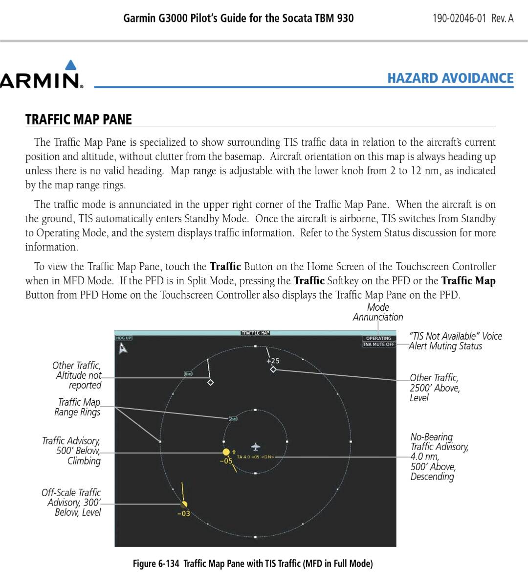
If you download the TBM 930 Guide for the G3000, it says specifically “The altitude difference between the requesting aircraft and other intruder aircraft is displayed above/below the traffic symbol in hundreds of feet.”
So whatever the number you’re seeing, add 00 to it. It does look odd that 03 is actually 0300, but it makes sense.
CasualClick thanks again for the follow-up. Did a lot of reading in the TIS section and below, great source. Got it now, just add 00 to what number(s) are showing. This being a bit different structure from what is communicated with ATC with a specific emphasis on the 1st#=10000s 2nd#=1000s 3rd#=100s. Putting a 0 before a # serves as a place holder.
TIS/TCAS/TAS has nothing to do with flight levels, transition levels/altitudes etc, forget this connection quickly. It says only where in the aur another aircraft is relative to you and what it‘s doing. It looks the same whether your above or below transition altitude, which is at different altitudes anyway depending on the country.
Yes I now realize it’s a reference unto itself…but when first using TIS/TCAS/TAS I was looking for the relationship between it and flight levels, transition levels/altitudes.
BTW, if Flight Level is the prefix to xxx when calling out altitude above transition…what is the prefix to altitude below transition?
Are you saying they would just read out 5000 feet…wouldn’t it be said 050 feet without the Flight Level being said before?
So 15200 feet is exactly how it’s said not 152 feet?
I’m not sure we’re making headway on answering your question. Might I suggest you try an IFR flight in the sim, and enable Azure TTS in the Sound menu? You can listen and hear the radio calls made to you by ATC, and you’ll get a sense of the flow and how they call out your altitude and/or instruct you to make altitude changes. That might help solidify matters.
Sorry for the confusion, I was asking, if below transition the nomenclature for a given altitude is different than for above transition.
I will listen more carefully to ATC…thanks.