If I recall correctly it was below the middle line. But, the thing is, the barometric setting was correct and I was at the exact altimeter setting called for at the waypoint, no deviation at all, and nothing I did would change that. But, as I wrote above, I loaded up the G36 mod, flew the exact same flight path and exact same procedures, and it took me right down to the end of the runway, no problems at all.
If I’m doing something wrong in the 172 I’d eagerly like to know what it is, because right now I cannot figure out why it’s acting like this in this plane but not in another.
Generally speaking, I aim for 100 feet below the fix, even with fully coupled VNAV. That’s old habit from Community Mod version days of the Garmin. Works everytime.
The other method is to to make it part of your checks to be sure you are below the glideslope before engaging Approach mode. I have been caught out by this before and I suspect I am one of many to have had this happen…
So, fly a hundred feet or so below the glide slope before hitting Approach mode? I’m just wondering why I would have to do that in the 172 but not the Bonanza.
I don’t know, but I can’t repro the issue. I fly the G1000 SP, the Bonanza, DA-40, DA-62 and other G1000 equipped mods. The technique is the same, the results are the same.
Alright, I’ll keep trying. I wonder if it’s the airports I’ve been trying - which one(s) have you used where the 172 will capture the glide slope properly? I’m not using any mods with the G1000 - just what’s available for free in the Marketplace.
I have very few custom airports - I think there are three - Gaya Block Island (which is now bundled for free in USA World Update 2) and a couple of freeware ones for the New England area where I’m based - like Martha’s Vineyard, Nantucket, P-Town. So for the most part I’m arriving at stock Asobo or first-party (Gaya etc) made airports.
I just deleted my post. I hit B key. but it corrected itself when I started my taxi. After about 5 feet it settled back to normal. I appreciate the reply though
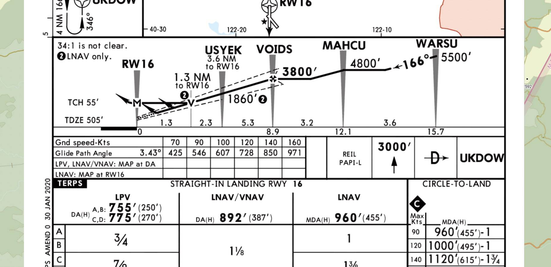
Thanks - still no luck here. I tried a different airport this time - KRDD. According to the charts, I should have picked up the glide slope at 3800 feet, but that never happened. The diamond cursor remained stuck at the bottom of the display, no matter how much I tried to force down my altitude with the VS function. The barometer was also set to the correct value.
EDIT: now I think I see what I’ve been doing wrong: I should be setting the target altitude lower that the altitude at the final approach fix. Once that happened I was able to pick up the glide slope at my “test” airfield.
@Bishop398 Matt - I recall having this convo with you late last year, is there still an issue with an Intermediate Fix AFTER the FAF but before Runway Threshold?
The Approach reads WARSU-MAHCU-VOIDS (FAF)-USYEK-RWY16. Can USYEK cause any issues?
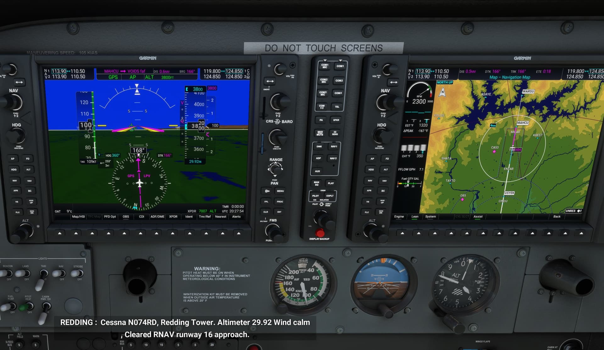
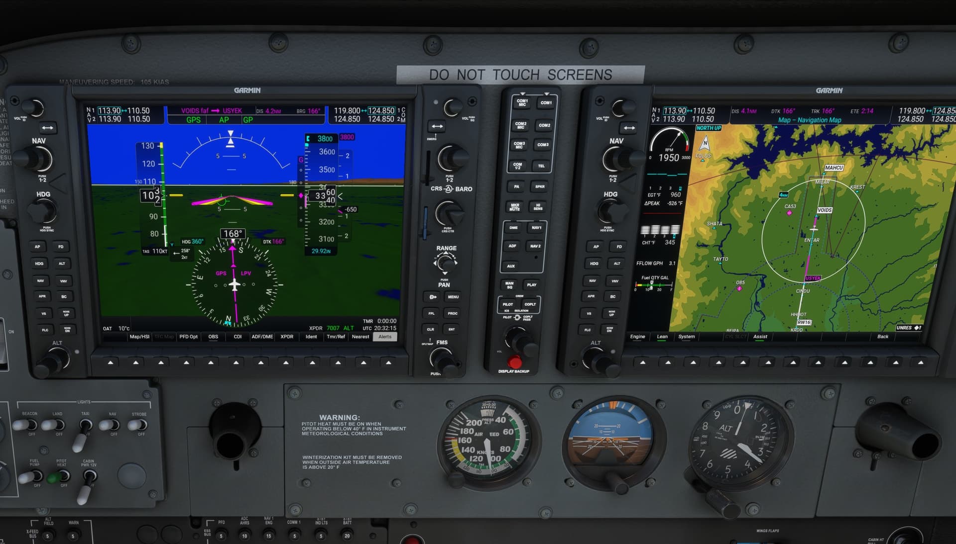
I just did a quick run on that approach. ATC even worked well at giving the step down altitudes at the appropriate times. I used the climb/descent arc to time my descents so that I was at the correct altitude slightly before each waypoint. The GP indicator showed up at the top of the box about a mile from the FAF, and started down as expected. As the GP indicator neared the normal mid point (just before the FAF), I engaged the approach button and it captured and followed the GP all the way down.
The intermediate point came and went and didn’t seem to affect anything. The NXi just continued to fly the correct approach all the way down to minimums.
So it seems to be working correctly on my system. Hope you get it worked out.
Regards
I went back and captured a screenshot of the approach about 0.6 NM from the FAF. You can see the hollow diamond GP indicator is approaching the midpoint. It’s normally at this point I hit the approach button. It’s already locked onto the lateral guidance at this point, and as soon as the now-filled in diamond reaches the midpoint, the NXi captures the GP and down it goes.
The second screenshot is shortly after hitting the approach button.
I see probably one important thing for check. Is your pressure correct? I mean, has sim correct data? It looks to me that your sim hasn’t because from your position, distance and pressure altimeter set you’re quite higher than you need to be. Try set for test altimeter pressure 29.92 as test. Simply said, in case your sim hasn’t correct data and you set altimeter higher, you’re higher than normally. Be careful here, maybe I expect you’ve set that altimeter manually, correct? Try set with ‘B’ key before approach to see if pressure is changed and set to correct local pressure. If it will be set to 29.92 as STD, check on web if this is correct with your expected airport actual situation. If it will be same then ok, if not then sim hasn’t correct data. Your situation can be just like in catastrophic films about crash with no correct data, Die Hard 2 is typical example but generally this crash is more typical as during approach to terrain crash prior catch LOC or GP of RNAV. I’ll be very careful to go lower than as published, here it plays big role if you have not correct pressure set. If you’re at ILS app LOC/GS you’re safe because beacon is independed to local pressure set on aircraft.
And just another important thing, your approach is looks like RNAV approach so no Glide slope is defined but only Glide path as is.
Yes, I’ve been doing some more testing and finding where I’ve been going wrong, namely, I’m too high at the FAF. Barometric settings and all that looks good.
simply if I see your screenshot at cockpit and see that you’re actually say half way from VOIDS to USYEK (check charts altitudes of both fixes), your altitude can be cca 2700ft at local pressure and your is 200ft higher.