Can someone please explain in detail or point me in the direction for the procedure using VNAV in the Garmin G3000. Including the use of setting minimums for altitude, not sure what altitude I should input…do not have navigraph charts.
1 Like
Same problem. It seems 9 out of 10 attempts to use VNAV in the VisionJet fail and I’m not sure why. I’ve watched the YouTube TBM G3000 tutorials, but the VisionJet G3000 doesn’t seem to behave the same way. That’d be great if there were a written procedure for setup.
For the VisionJet right now, you should refer to FlightFX support. It currently uses a custom version of the old Working Title G3000 mod and doesn’t use the new G3000 that came with AAU1 that is currently in the TBM. I’m not sure what the procedure is for VNAV in that custom unit.
Thanks for the quick reply. I was doing alright with everything until I learned VNAV in the Baron G58. Got spoiled by that experience and then disappointed when I tried to apply what I learned to the VisionJet.
It’s not like I can’t go back to the old ways and land the VisionJet by glide path and hand flying, LOL!
Hope the FlightFX team is making progress, I really like that little jet. Maybe I’ll spend some time with the TBM, I hear the G3000 fix works great with it.
Try reading the comments here. Just a couple of posts back I explained why this is. Once again you cannot currently compare the Vision )et with the TBM when it comes to the G3000. So using tutorials or procedures from one or the other is not going to work until the vision jet ditches the old version of the G3000.
2 Likes
Indeed. I’d gone back in the string and now understand why the VJ G3000 isn’t playing well. Thanks!
I don’t think I’ve been able to find it mentioned in this thread or anywhere else… but is there not a way to access the “Create User Waypoint” screen if I load into the sim and manually input a flight plan? I seem to be able to only access it if I have custom waypoints entered from the MSFS map before loading in. Is this correct?
Found this in the Discord…
Waypoint Info → Create User Waypoint → LAT/LON
Serious CTD m Xbox s using Honda jet. Black screens on every single load. Anyone else getting this problem with G3000/5000
Just as a clarification - the V1.x Vision Jet is using a custom VNAV that is very barebones. That will change when V2.0 Vision Jet leaves Beta (TBD) since that will use AAU1 G3000 among other changes.
Please do join us on Flight FX Discord so we can assist owners having challenges as this thread is for the MS Official AAU1 G3000/5000.
Disclaimer: I am also a Flight FX Beta Tester and “Advisor” for the Vision Jet.
2 Likes
With the newly updated G3000, how do you insert a visual approach into the flight plan? With the G1000 it’s part of the drop down list for a field’s approaches. But I don’t see that option in the G3000. Is it not implemented?
LOL! Please “advise” Flight FX to hurry up with the transition to the AAU1 G3000/5000. Would really like to have functional VNAV.
‘All things come to he who waits’ ![]()
Nick posted an update on the Discord - the Beta is underway.
1 Like
I’ve been able to follow YouTube tutorials and have VNAV work in those circumstances. However when I try to apply the procedures (correctly?} it doesn’t work for me.
Say I leave without benefit of SID, a private ranch airfield in Texas and fly to another private ranch airfield in Oklahoma (jus’ checkin’ on my cattle), can I employ a VNAV climb to altitude, then a VNAV descent, without benefit of STAR? I think I’m having problems as to when to apply the VNAV programming.
Thanks in advance, old and slow learner. I used to start my plane by spinning the prop.
Visual approaches are in the G3000/5000 in those approach lists. I’m talking post AAU1 versions here so if you are using an aircraft that has the old version like say the SF50 then that may be different.
1 Like
It seems more work to VNAV climb - not sure why people want to do this. The two CFIs I’ve had both said the same thing - use the altitude pre-selector to dial in a target altitude, press FLC and adjust your climb speed to either best climb rate (Vy) or best angle rate (Vx). Both are depicted in the TBM and the Longitude. The FMS will level you off at target altitude, you just have to press B every so often to make sure the pressure hasn’t changed during your climb (or you passed the Transition level).
1 Like
I agree, I have never known or seen VNAV used for climbing. Set the target altitude and use FLC to climb to it.
Maybe ascending from an airport where you’re faced with multiple altitude. speed and distance from the airport? Seems all those parameters can be programmed into the G3000/5000 and you can read your magazine or catch up on social media while the aircraft and computer get you to cruise altitude ![]() .
.
I think climb using VNAV is a solution to those complex departures, and the appropriate time to go to VNAV involves TO/GA and appropriate use of the Flight Director.
I have my best luck with descent by waiting until just after the TOD, then engaging VNAV. Still trying to get the hang of it. Worst case, I can hand fly but I’m a technology nut.
On all the Garmin units (ours and IRL), VNAV is not a path based climb mode like exists in airliners. Instead, you must use VNAV along with another vertical mode, such as FLC or V/S, and all VNAV will do is level you off at constraints.
3 Likes
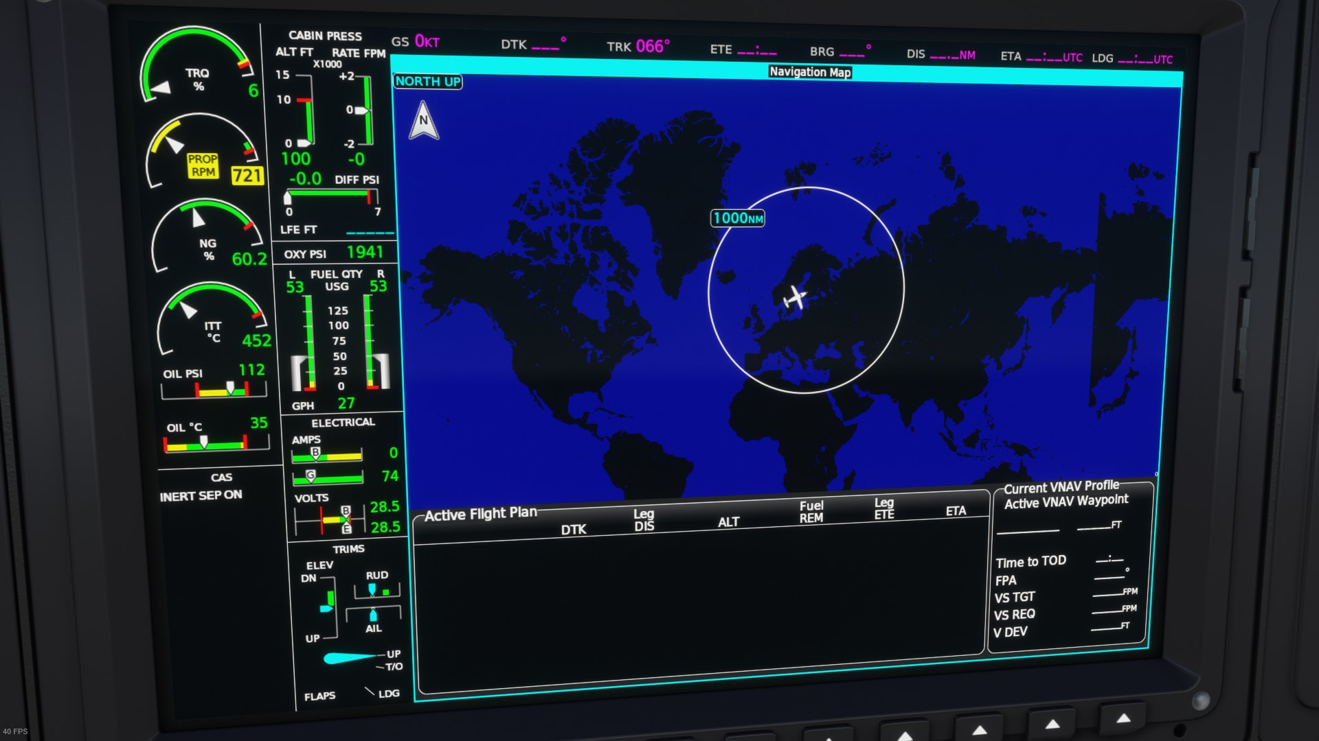
Hello, I’m seeing some visual artifacts on the MFD in these 2 screenshots.
In this one the eastern portion of the world is repeated.
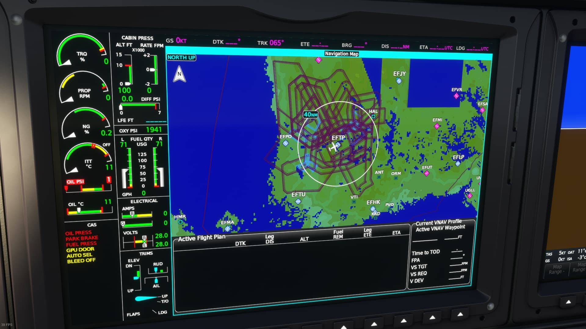
In this one a part of the airport is repeated and there is a weird red line going across the screen that shouldn’t be there.

EDIT: heres a third oddity. The terrain is low-res, pieces are missing and the airspaces clutter the centre but not other parts of the screen.
Are these bugs? Is there a way to turn off the airport taxiways overlay? Thanks.