Dear Asobo Programmers and Flight Simulator Developers.
As for my understanding, the Development of MSFS geographical system is based on Mercator WGS84,
But logically, relative to real-world physics of objects moving in 3-dimensional planes, need to follow the laws of physics and geometry.
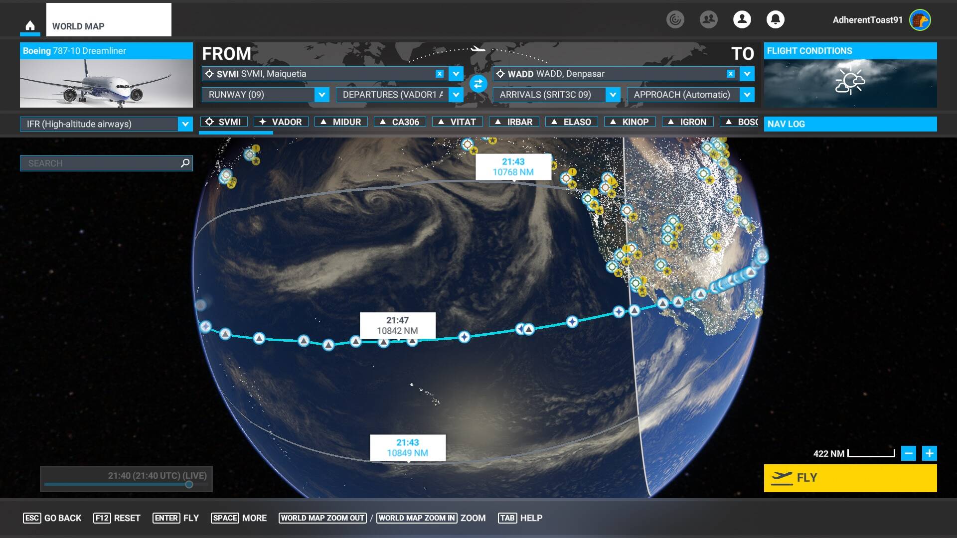
It seems that when I create the route between two points (IFR High) I get three routes possible as shown in the attached pic. But it is not logical by the geometry of spheres that all routes will have the same flight time, not according to any mathematical equations or by physics.
The Route being closer to the equator should take longer. as the Nautical Miles at the equator are longer than the nautical Miles at the poles.( law of haversines).
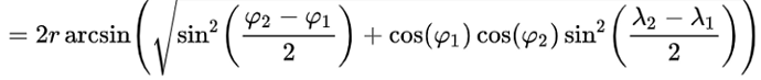
The Equation for the distance between two points according to haversines rules, and this equation can be used in order to calculate the accurate distance between the waypoints, which you will conclude that the distance near the equator is longer.
And adding to the fact that the routes are calculated relative to the shortest distance possible, then the
routes depicted have to be the shortest ones to any other, but between them also there is a shortest route, by the algorithm of calculating the routes, we can conclude that the routes are considering the length relative to the sphere.
Please solve the bug, so that we all will be able to experience real-world physics.
Thank you.
Mhhh, could it be that they (correctly) add up the length of the individual segments? That would most likely not be the same length you get when you just use a straight line around the periphery of the almost round earth ball?
But the Earth is not a perfect sphere. And at the equator, the circumference of the sphere is larger than the circumference at any longitude above or below, so it can’t be the same length of routes.
This would, of course, not be true if the departure and arrival were on exactly opposite points on the earth’s surface - in that case (assuming the earth to be a perfect sphere), all routes would be exactly the same length. Your departure/arrival points were pretty close to this.
Thank you for your answer, but when moving up or down through different longitudes, the proportion as you get closer to the pole, the circumference gets shorter, which influences the overall length of the route.
OP, in your picture I see two wedges. Has anyone ever cut two wedges out of a spherical object; like say an orange? The two radius sides of a wedge in theory should be the same distance, assuming that the two tips of the wedge are origin and destination respectively. You may be overthinking this.
Can you please calculate the following statement in simple math please…?
The distance between two points in Euclidean space is the length of a straight line between them, but on the sphere there are no straight lines. In spaces with curvature, straight lines are replaced by geodesics. Geodesics on the sphere are circles on the sphere whose centers coincide with the center of the sphere, and are called ‘great circles’.
So that we both can understand how the great circle is implemented in MSFS.
Not if the points are exactly opposite, as I said. If you move one point northwards, the other would move southwards, and the distance would stay the same.
I understand, thank you for your answer, but then can you please explain to me why the algorithm of the route finder is always heading northward when the two points are in the northern hemisphere and why the routes move toward the south in the southern hemisphere? And how the great circle is implemented in the algorithm of calculating the shortest route possible?
Moreover, the time flying those three routes can’t be the same.
And if you look closely, the upper route in the screenshot has the same estimated time in route, relative to the lower route, which is closer to the equator. That is illogical by any physical law.
If the two points are on the opposite side of the earth, they cannot both be north (or both south) of the equator. In your original example, the two points are at about 11 degrees north, and 9 degrees south, very close to being exactly opposite.
If the two points are not opposite, and both north of the equator, then the great circle route would certainly be northwards. In that case, any deviation from the great circle route should be longer, so I would be interested if you have an example showing otherwise.
So look at the three routes in my screenshot, and at the timing of all routes, and then think about the great circle, and it’s implementation in the time is calculated, does is seem logical to you by simple math that they all would have the same amount of time en route?
The origin and destination in your MSFS generated flightplan, is pretty much almost one side of the globe to the other. It only stands to reason that the two alternate routes would be almost the same. It may make a difference if plotted from the opposite side of the globe, but here the alternate routes in your photo are too close together to make a significant difference in distance.
Out of curiosity, I plotted the route in simbrief. Since this is not a flight that happens IRL by commercial airlines, Simbrief has zero waypoints other than origin and destination. Heck simbrief cannot even bring up SIDS or STARS for this route. For what it’s worth, the distance according to Simbrief is 10638nm. Which is very close to all three routes you have in your photo.
If the departure/arrival are on exactly opposite points on the earth’s surface, any direction would be a great circle. An obvious example would be the North and South Poles. All routes from one to the other would be along a great circle (in this case following the lines of longitude), and would have the same length.
Your departure/arrival points are extremely close to being opposite, both in latitude and longitude. I would expect all routes between the two to be very close in time and distance. All this does not take into account the non-spherical shape of the earth, of course.
Exactly, which means that the routes can’t be flown in the same amount of time.
By the way, the reason that all routes in MSFS are calculated by the logic of the great circle is what enforces the reason that routes closer to the equator have to be longer, and not the same distance. And there for the time should be longer and not the same.
The equation you quoted previously is for a perfect sphere. If you are now saying this is all due to the fact that the earth is an oblate spheroid, this seems to be a change in your argument.