great way of letting us take part on my PLN! Can you tell the differences between 2020 vs 2024 in the area? (I:m still on 2020 and will stay until the chaos has subsided).
The Jenny is a bit weak, the Chilton DW1 (currently discounted on the MP) probably comes closest to her IAR-22. As does the Klemm 25, in dev limbo for years now:
Re: MSFS Klemm L25 - Page 4 - www.classics-hangar.de
tally-ho
RF
Hi @RegentFalke4131 - I’ve not used 2020 since 2024 was released. In general non-bespoke areas like this my impressions are that:
- 2024 has better trees due to the new biomes, but more trees than probably exist in real life & in 2020.
- Ground textures have not significantly changed.
- The procedurally created houses are better, as is road traffic (lights on at night)
- Lighting is much, much better.
- Clouds are better at times, but I’ve yet to see true cirrus clouds.
Yes, the Jenny is not the optimal aircraft. In addition to your suggestions, if users have the aviator edition in 2024 (or have purchased the local legends or famous fliers in 2020), there are a number of aircraft that would be better suited to this route.
Don’t you notice that the forests and wooded areas are less dense than in FS20? I see a lot of areas where, in FS20, it was much more populated with trees, and now there are many more clear areas when there should be denser forested areas, reminding me too much of the forests from FSX/P3D and the old autogen. Sorry for hijacking the post, by the way.
UZBEKISTAN: Western Tien Shan (15.200 ft)
The International Geophysical Year (IGY) was an international scientific project in 1957/58. The Academy of Sciences of the Soviet Union financed a number of expeditions.
Here you fly a group of geophysicists to the mountains of the Uzbek Soviet Socialist Republic (with an excursion into neighbouring Tajikistan (along Chimtarga Peak 18.000ft)).
The only available chopper at the time (Mil Mi-1) doesn’t have the service ceiling required so you have to take the trusted AN-2.
Land often (WPs, on gravel, grass and glaciers, sometimes tough/sloped XXX) for measurements and sample collection.
Uzbek_TShan.PLN (7.3 KB)
FRENCH POLYNESIA: 3500ft
We do a Heliborne geophysical survey of the French Papeete Islands in the middle of the Pacific Ocean.
From your chopper abseil scientists on top of the mountains - the DEM is on par with Hawaii, creating some spectacular ridges.
While the altitude is not necessarily “high” beware - you start counting from sea level.
F_Polyn_Papeete.PLN (3.8 KB)
CENTRAL ANDES (21.500 ft)
Looking for magma chambers, faults, seismicity and the related geologic hazards of active and dormant volcanos along the watershed of Bolivia, Chile & Argentina.
Instruments on the aged Fokker F27 will measure variations in the Earth’s magnetic field and natural low-level radiation up to several miles beneath the surface. This information will be used to develop geologic maps in three dimensions.
You have to fly the airplane at a height of 300 to 1,000 feet above ground !
andes_central.PLN (9.9 KB)
THE HIGHEST RAILWAYS
You are a photographer for a railway journal, covering the highest train rides in the world from the air.
Follow the tracks low and slow and find the stations - not always easy in the sim (LittleNavMap helps). There might come a time when we can see rolling stock from the cockpit… 
1 . Empresa de Ferrocarriles Ecuatorianos
This railway through the Andes was severely damaged by heavy rainfall during El Niño events and is only partially restored. You start and land at sea-level and climb to the highest point near Urbino (11,841 ft), no problem for your Cessna 337 (Service ceiling: 19,500 ft):
A major gain in altitude was made at the famous Devil’s Nose (Nariz del Diablo) where the train shunted back and forth along the rocky promontory, unfortunately the sim (2020) is devoid of details there:
HIRAIL_ECUAD.PLN (5.5 KB)
to be continued
This one is a good excuse for flying the new C185 for the first time. Thanks for sharing.
TRAIN INTO THE CLOUDS (13.850ft)
The Salta–Antofagasta railway links Argentina and Chile, passing through the southern Andes.
Its central part “Tren a las Nubes” alone has 29 bridges, 21 tunnels, 13 viaducts, 2 spirals and 2 zigzags. It culminates at the Viaduct Polvorilla, an important tourism spot, unfortunately not modelled in the sim:
Following the tracks westward to the Pacific over lakes and salt pans, make a stopover at the giant telescopes in Chile for some great photo shots at sunset.
HIRAIL_LasNubes.PLN (11.3 KB)
BRAZIL GLIDER (6000 ft)
While WU19 is disappointing DEM-wise (e.g. region Pico Neblina 9500ft, Chapada Diamantina NP Tepuis - see my respective “Pioneers”-Posts) the “Serra do Corvo Branco” coastal mountains apparently have a higher resolution than the rest.
We go for a magic carpet ride in a glider along this escarpment. Set up a strong wind from the Atlantic and use the ridge lift to good effect.
Start @ SIJN, detach from the Cessna
@WP2 (Mt Pedras Blancas) and head south along the promontories. Try to reach SSTE at the ocean front, a difficult crosswind landing.
You will pass Peak “Morro da Igreja” (1825m) and its radar station (radome not modelled) : the coldest point in Brazil (-18°C !), a tourist attraction when its covered in snow:
Otherwise, watch out for the lush cliff vegetation, winding roads and magnificent waterfalls.
BRAZIL_glider.PLN (5.9 KB)
BOLIVIA: A VISIT TO THE STEAM LOCOS (15.700ft)
The Bolivia Railways photo trip needs cheaper arrangements. For some Dolares you can join a rather dubious guy who “has to deliver some stuff” with an old C-45/D-18.
The pilot starts in the Atacama desert @ SCCF Calama, cruises along salt flats and will drop you in the end @ SLET Santa Cruz. For your money he will follow the tracks low and close - but you are somewhat apprehensive due to some landings as high as 13.000ft…
On the way you come along “Estacion Cóndor”, the Western Hemisphere’s highest railway station (4600m). Occasionally passing the hulks of old Steam locomotives including the famous “Train Cemetery, Cemeterio de Trens” at Uyuni (with a total of around 100 locos!):
In Potosi circle the famous but deadly Silver Mountain, Cerro Rico:
From here to Sucre the tracks are one of the most picturesque in the world, winding through the mountains, try to get a good shot of the Railbuses.
Finally you will end up in the jungles of the Amazon.
HIRAIL_Bolivia.PLN (6.2 KB)
This one looks awesome. I love the backstory. Thanks again for sharing.
your mountains look like rounded blobs, they dont represent actual mountains, Asobo should do something, like 2 meter mesh for global coverage. Mountains in some of your pictures look like hills, not mountains. i may be a pessimist, but so be it.
USSR - into the soft underbelly (17.800 ft)
In the 1950s the CIA and the USAF (580, 581, 582th Air Resupply And Communications Wings, pic below from Wikipedia)) had a joint clandestine operation going:
Grumman Albatros’ landed on lakes and rivers deep in enemy territory to drop and pick up personnel. The black-painted planes penetrated Warsaw Pact countries, the Balkans and even USSR airspace.
US hikers can still see the wreckage of a HU-16 that crashed on a training mission in Death Valley:
https://www.sfgate.com/california-parks/article/cia-spy-plane-crash-death-valley-19974450.php
One of the longest such missions is not yet declassified:
picking up a high ranking Sowjet defector on huge Lake Issyk-Kul. He is waiting on a boat right in its center.
Glide in just after dark, find his shielded strobe light, land, bring out the anchor, wait some hours and re-start at dawn.
You begin/end in friendly Afghanistan and go deep into the former Sowjetunion (today Tajikistan and Kyrgyzstan). Always fly low along uninhabited mountain ranges to avoid detection, high peaks are used as nav beacons.
As I’m still on M2020, I had to divert to the free PBY Catalina, the Grumman has a substantially higher service ceiling that helps to get over the ridges.
USSR_YSSYKOEL.PLN (7.3 KB)
HIMALAYA DISASTER RELIEF: Bhutan
Earthquakes frequently shake up the highest mountains on earth:
Here little state Bhutan is hit hard: roads are closed, bridges collapsed - we use some spring sale items (and freeware) for help.
A. Paro Valley
A chopper is stationed on VQPR - it is immediately scrambled to look for the fate of denizens in important buildings, including the famous Tiger Nest:
Tashi N.Resort: land on riverside grass
Gangtey Palace: skid touch land
Tara Monastery: land on lawn
Gorina Monastery: land on nearby field
Tengchu Gompa: land on lawn
Tseteo Gompa: rappel into inner courtyard
Drukgyel Dzong: rappel into inner courtyard
Taktsang Sarp: hover over roof
Zangdok Pelri Temple: hover over roof
Paro Taktsang: rope ladder evac from lower terrace
Ugyen Tsemo: hover over courtyard
Yoesel Gang: hover over roof
Kunga Goling Temple: skid touch land
Sangka Chhoekor: land on lawn
Girikha Lakhang: skid touch land
Nat. Museum: rope ladder
Zuri Zhong: hover over roof
Pelri Gompa: land on nearby hill
BHUTAN_1.PLN (5.5 KB)
B. Border Patrol
By lucky chance a charter BN-2 Islander was on Paro when the tremors started.
Its now commandeered to check the peaks on the northern border and to look at villages in the southern hills.
BHUTAN_2.PLN (6.4 KB)
I use this yellow out-of-place livery as a tribute to an Airfix Plastic Kit I glued together as a boy…
C. The Big Lift
Indian_AF C-17s land next to the damaged Paro runway with heavy equipment for tarmac repairs.
BHUTAN_30.PLN (2.1 KB)
Desperate times require desperate measures:
international aid agencies want to bring in fully-loaded Cargo-747s from the south. Its tough but manageable.
BHUTAN_31.PLN (2.1 KB)
D. Little Lift (Indian Big Choppers and/or Caribous) bring help to remote locations.
BHUTAN_4.PLN (3.9 KB)
Next ; Himalayan PLNs - will be in Myanmar, stay tuned.
somewhat fitting to last post - if they can do it you can do it  :
:
Epic: Thai King & Queen Pilot Their Own 737 For Bhutan State Visit - One Mile at a Time
Was the sim they did train for several days to get in/out of Paro our MSFS? 
MYANMAR Himalayan Disaster Relief II (19.295 ft)
The country was hit hard by the recent earthquake, regions in the periphery have been cut off. As they are largely under rebel control the government does not allow helicopters to go in there. Only Thai PC-6 Peacemakers are finally permitted to bring desperately needed food- and medical- aid.
A. Village supply
Start in famous Bagan, and go west-then-north along the Indian border. Always try to land at/near villages so that the onboard medic can take action as required. Your pilots STOL skills are put to test! Only as a last resort drop the sacks with rice, powdered milk and pills .
Stock up @ VYHL and continue to VYKI.
MYAN_m1.PLN (6.3 KB)
[Hint: for fans of the “Air America” Porters and their incredible “Lima Sites” in Laos:
its a good substitute as the Sims surroundings here are much better.]
B. Landslides
First another village supply run. After Pangsau (@ the famous Burma road…) the country becomes mainly unhabited, check for landslides in the jungles and land @ VYPT.
MYAN_m2.PLN (4.7 KB)
C. Mountains
You fly along the Himalayas, looking for quake-induced rockfalls, avalanches and mountain lake spillovers. Pass Myanmars highest peak: Hkakabo Razi 5.881 m (pic).
Descent and pick up supplies @ VYNM and bring them to the villages in the long valley near the Chinese border.
MYAN_m3.PLN (6.8 KB)
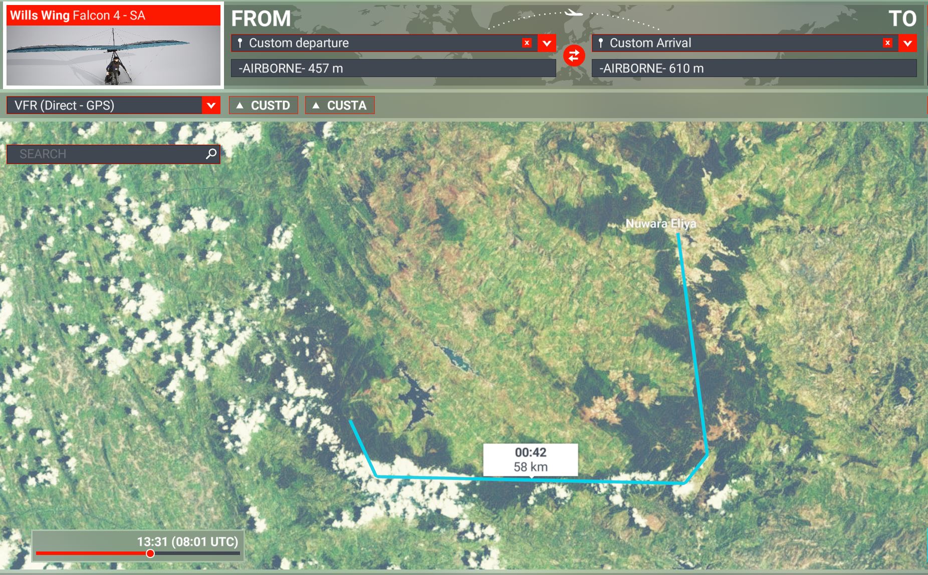
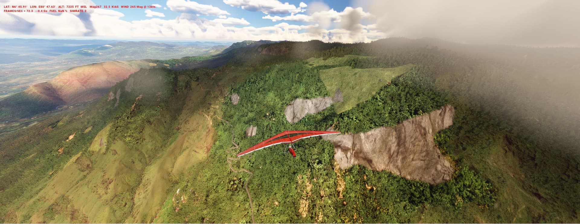
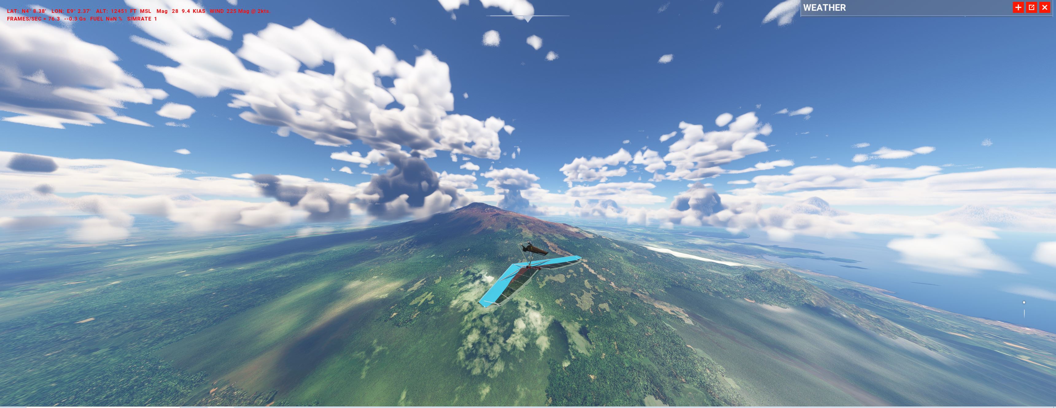
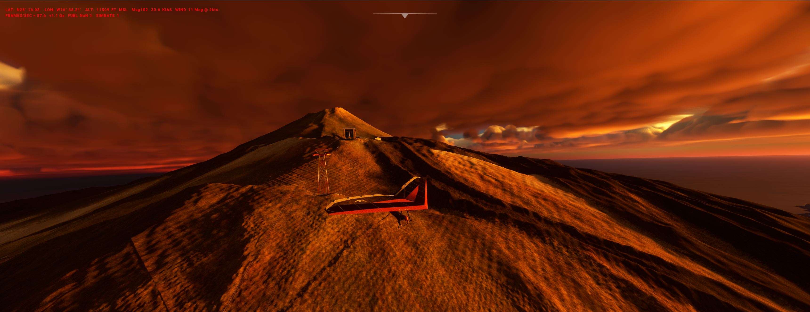
HANG GLIDING - the last frontier?
And now to something different - there is a free Hangglider:
https://flightsim.to/file/72162/wills-wing-falcon-4-hang-glider-stand-alone-version
As the representation of sim thermals is still hotly debated, lets use a strong southern wind for a ridge-lift, distance-flight along a little-known but dramatic tropical escarpment.
SRI_LANKA_HANGGLIDER.PLN (1.9 KB)
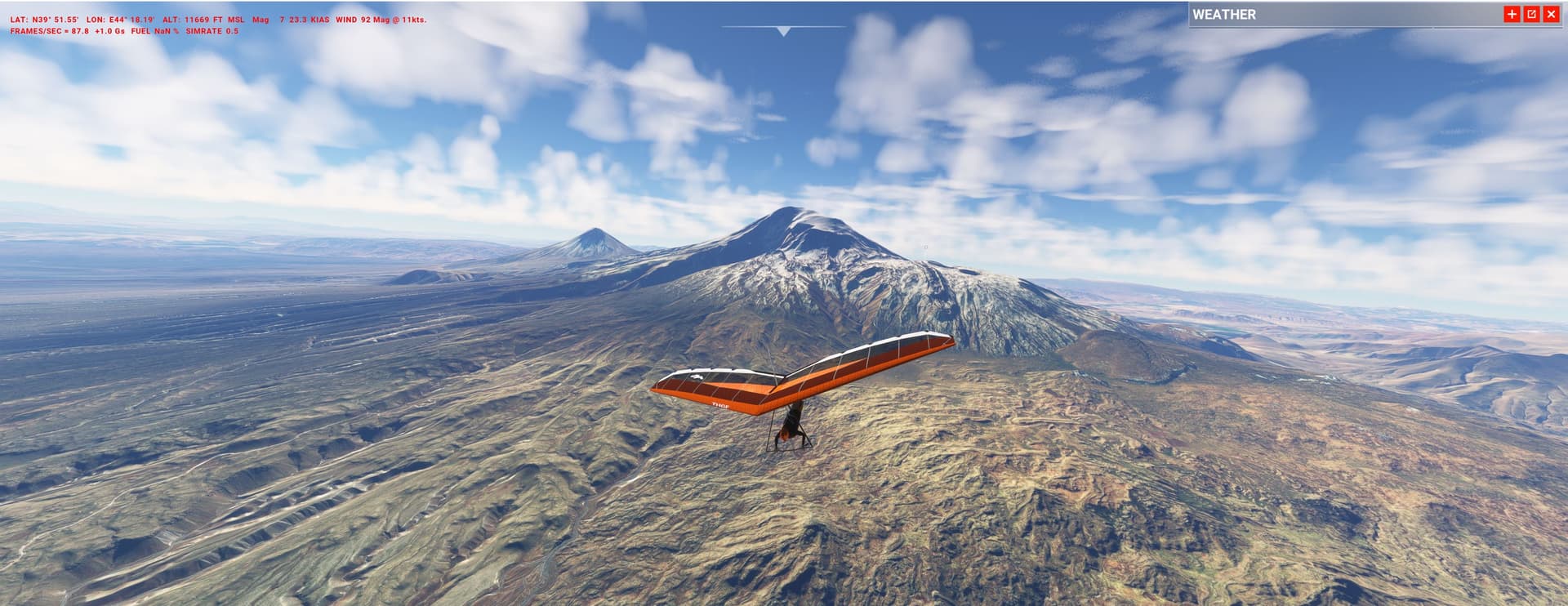
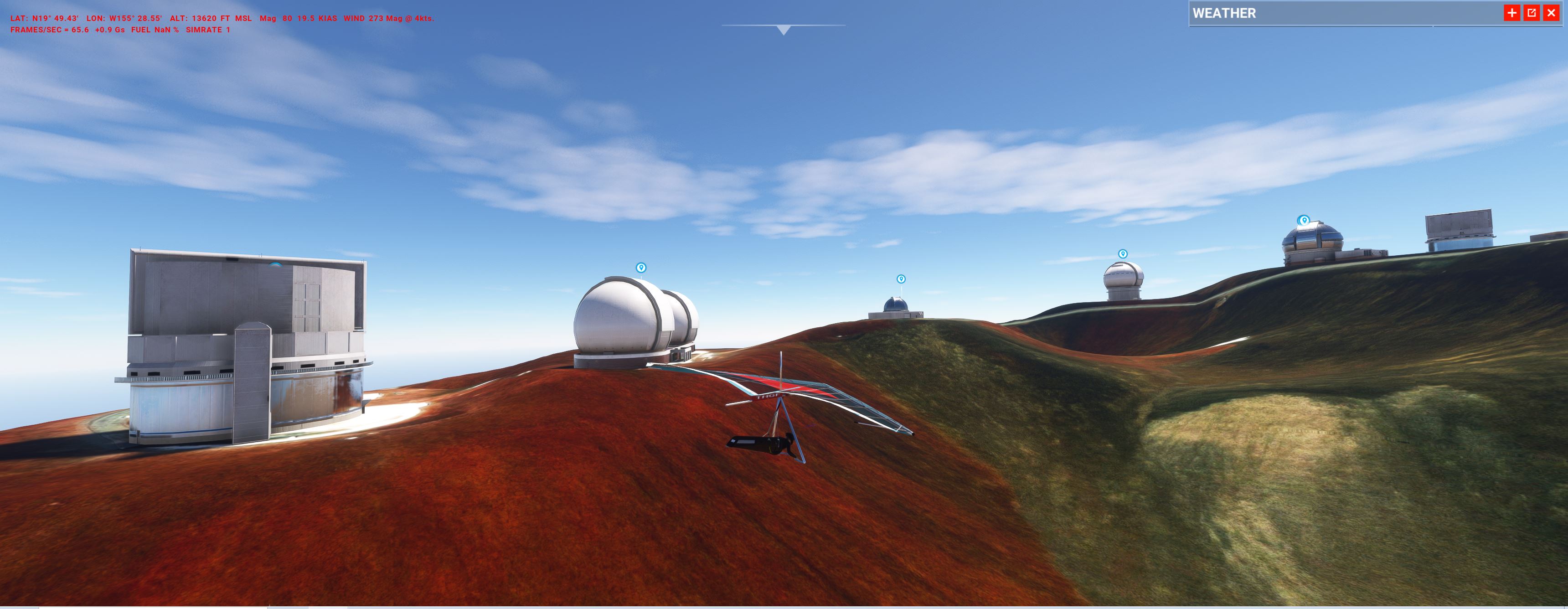
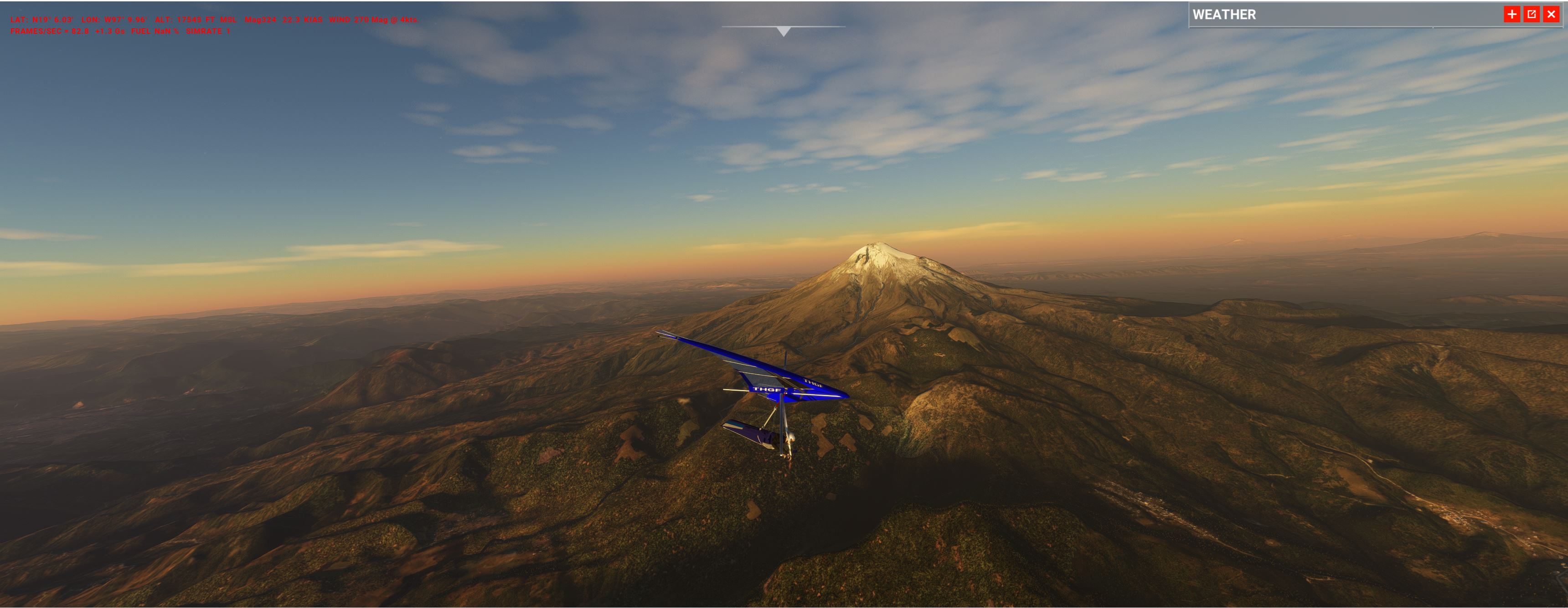
And we can go much higher: hang-gliding from Everest and other 8000m-peaks had been tried since 40 years.
Jump start from the roof of the world and try to reach Lukla or at least Namche.
Its also high adventure to use prominent peaks which havent been touched by this Blog so far, can you guess its whereabouts? :
HIMALAYA: Tensions in the eastern corner (25.500ft)
The Sino–Indian border conflict is an ongoing territorial dispute over the sovereignty of Himalayan land between China and India. It resulted in outright war, border clashes, military standoffs and skirmishes until today.
The “Aviation Research Centre ARC” is Indias secret special operations unit, involved in that controversy from the very beginning.
A. In 1962 the CIA provided the ARC with the cranky looking but effective Super-STOL Helo Twin Couriers:
They were used for clandestine flights north to check possible landing spots, access for climbers hauling monitoring equipment up and to infiltrate recon commandos.
We have to replace the Helio with the CIAs workhorse, the (ski) Porter, on the way passing mighty Duojie Aizhong & Namjagbarwa Peaks (nicely modelled) and diving into the valleys.
IND_east_cia.PLN (2.8 KB)
B. The ARCs Recce MiG-25Rs (in the Marketplace from GKS) were kept a guarded secret, designated Garuda after the mythical bird. With its speed and altitude they could fly over China with impunity (1980-2006). We start from Hasimara Air Force Station (Indias biggest, VE44).
Here is a cockpit side view from 75.000ft:
ind_foxbat_china.PLN (2.3 KB)
C. Today the ARC operates a number of heavily modified, “black” business jets (Gulfstream & Global Express).
We take the Citation for an ELINT flight along the strange shaped border. Navigate carefully to avoid an international incident but stay close to the peaks to complicate radar tracking.
INDIA_AR_PRAD.PLN (4.8 KB)
CANADA: Mackenzie Mountains (10.000ft)
1950 - Broken Arrow Alert - i.a. an aircraft with nuclear bombs is missing.
A B-36 (see Virtavia pic) on the way home from the North Pole to the US Mid-West, is supposed to have come down over Canada in the remote Mackenzie Range.
The Royal Canadian Air Force launches a SAR-Op to find the missing plane, radiating debris and hopefully survivors:
A. a RCAF Canadair C-5 North Star (aka PMDG DC-6) - outfitted with isotope sampling scoops and airborne geiger counters will search in the west. Passing famous Virginia Falls (ups, see pics, Bijan where art thou?), the regions only habitation (Tungsten mine) and the two highest peaks (Nirwana & Keele) it will end up at CYFP on the coast.
CAN_MACKENZ_W.PLN (3.3 KB)
B. an Arctic Rescue Catalina will fly east along the river valleys (Nahanni, Yukon, Snake, Peel). Land whenever possible (beware of log jams) for radiometer measurements or to talk to first nation hunters spotted in tent camps - have they seen anything?. Final destination is Inuvik.
CAN_MACKENZ_E.PLN (5.0 KB)
The reality behind - the B-36 crashed further west:
Debris can still be found:
https://journals.sagepub.com/doi/pdf/10.2968/060006008
PS:
The M2020 landscape there flips between good & bad.
The strange arctic effect again: distant mountains seem to look good (albeit blurry) - but when coming close get suddenly a bizarre overlay of FSX-type rectangles. Whats going on?