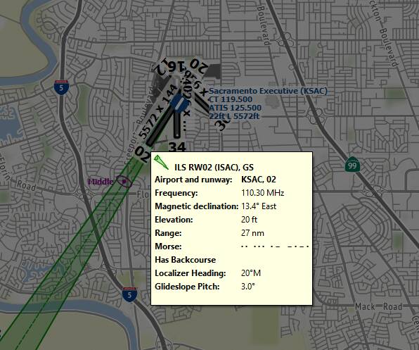
Little NavMap does that too - with the added advantage of a fullscreen mode (toggle with SHIFT + F11)
It shows the info on a mouse hover (1st pic) and in a docked window (2nd pic) of a selected airport.
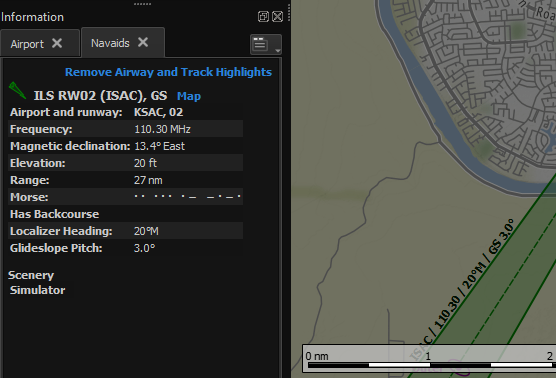
Little NavMap does that too - with the added advantage of a fullscreen mode (toggle with SHIFT + F11)
It shows the info on a mouse hover (1st pic) and in a docked window (2nd pic) of a selected airport.
Just want to throw this in for usage with LNM…
So you are the one behind putting those maps into LNM. I’ve been using them for a while and cant imagine LNM being without them. I couldn’t remember where I got them from.
I specially like Google road map, sat map & the sectionals implementation.
Thank you very much for sharing your work ![]()
No, not me. Sorry for the misunderstanding.
Hi @CDRMaz
Since you have answered me in this forum, I have been watching videos to decide which flight plan program to choose. I am looking for a very simple one: that I can see on the map the course I have to follow to go from point “A” to point “B”, and that I can see the distances, the cities I have to fly over and that I can reduce the map over which I fly, to share it on the monitor screen together with the scenery seen from the cockpit, or from outside the plane.
In the end I have decided for the one you suggested me: “VFR map complement”.
Due to my little experience in these activities, it took me a lot of work to install it, but in the end I found a lot of difficulties like these:
l reduce the map to share it from the cockpit with the external scenery in flight.
the menu chart is extraordinarily reduced, making it impossible to read its sections for each chart that is requested to be displayed on the screen.
when zooming to reduce or enlarge the map, it is not possible to read the texts of cities and everything else on the map, it occurs at the precise moment that is enlarged or reduced, only for an instant, I can see the names on the map but instantly disappear and there is no way to read it again.
When I fly with the map open next to the cockpit, certain actions such as moving from the view inside the cockpit to the outside view (END key), does not work, nor do the side views from the cockpit and from outside the aircraft, etc.. If I make the map disappear, I get back the control of all command and control functions with the keyboard keys.
I am convinced that these problems occur because I did not do something correctly, but what did I do wrong or do wrong.
You who seem to have and value very positively this VFR map add-on, I hope you clarify it to me, otherwise, I will not be able to use it.
Is it possible to draw on the map a line from point “A” origin, to point “B” destination and make the plane fly on that line.
I look forward to your help to see if I can enjoy the flight and the map more fully.
Thank you in advance for it.
Kind regards: Delfin
As suggested by others, I would STRONGLY suggest you use Little Nav Map, as it either directly does exactly what you want (show your position on a map, as well as other nearby planes), and gives tremendous detail on airports etc, especially for VFR flights.
You can even plan flights, and follow the line manually if you desire.
For the planning (as in settign a point to and from and flying it), Again Little Nav Map can help, you draw the flight plan on LNM, and then save the flight plan to disk, and load it up into MSFS, and the aircraft Autopilot will help fly the course.
You can also plan on MSFS, save the flight plan and import it into LNM to visualise your flight plan on LNM.
LNM works best with two or more minotors, but its not diifcult to ALT TAB, if you have a single monitor
Your problem with not being able to zoom and pan the cokpoit is because you have the map window selected, and all movement is sent to the map window, and you need to re-select the main window.
Everything you have asked for is possible with LNM. There are also other tools too, if you wish to try.
Download and install LittleNavMap
.. just unpack the zip-file in a new directory on your desktop.. and click the littlenavmap.exe, it will work.
I find I don’t need any external app to see which towns I’m flying over, or which are nearby. I use a free addon:
https://flightsim.to/file/11078/grodden-s-world-poi-pack
This will add 135,000 city and town locations into your virtual world in the style of normal POI. Works perfectly well for me. It might be useful to turn ‘cities’ off in the world map filter (to stop them all appearing on your world as tiny little white dots), and if you want to turn off these names in-flight you can do that through ‘Navigation Aids’ in options (just untick them).
Just download and extract the ZIP into your ‘Community folder’. Done. You’ll have two folders there:
gmx-geocities1
gmx-geocities2
Leave them alone. Don’t fiddle. They work fine.
I haven’t yet found a better, less trouble-free, or convenient way to have my virtual world annotated in real-time, in-sim. For me, it’s an essential addon.
What I would suggest is a “POI Billboard of” series at https://flightsim.to/profile/RipPipPip/uploads
I’ve had that installed for a short while, before using LittleNavMap.. but it really is a clutter of 135K extra markers ! in NL (and GB) it results in a LOT of extra blue markers in sight, some hiding others.. and POI’s.. I prefer a proper map. In fact, the city names should be visible on the globe (only, imho)
Hi @ArcanoPython931, @SenseiLeNoir, @SavvySigma.
Due to my limited time available, I have not been able to respond to those of you who have informed me (and very extensively, no less than 30 “virtual friends” have bothered to provide me with information).
You have been one of the most insistent that I download LittleNavMap. After downloading “VFRmap” (and that works very badly for me), I downloaded “Volanta”, finally and just yesterday, I downloaded the program that you have insisted me so much. Also @SenseiLeNoir, has insisted me STRONGLY, to opt for LittleNavmap, and…so I did. And another one who also made an effort was @SavvySigma. After so much determined insistence, in good logic, you are obviously right.
Indeed, LittleNapMap, is a frankly remarkable program, so remarkable, so wide and deep, that for me it is a huge ocean of information; I will not use even the hundredth part of its content.
IN SUMMARY: I basically practice “free flight”, and therefore I really only wished initially something very simple: to go from “A” to “B”, in whose trajectory I decide: the airplane, the speed and the altitude; the course will be indicated to me by the marked route from the origin to the destination (“A” “B”. ). And I also want that the plane that is flying, is seen on the trajectory indicated in the “LittleNavMap map”. I suppose that among many other features, it has also this one: aircraft flying over the route traced on the map. If you know this program well, does LittleNavMap have this feature?
The large aircraft, twin-engine, four-engine, etc.. I flew them in the previous FSX, and lately in Aerofly FS-1 and FS-2 and, generally at the altitude that usually fly with those “birdies”, I do not see the scenery at all (they fly far from the ground); the speed is usually uniform, and they require a meticulous planning to work automatically. All that planning bores me, doesn’t stimulate me, and doesn’t bring me satisfaction. I fundamentally like the stoll, the canard and above all the acrobatic ones, these are my real weakness. And naturally, in this type of free flight, at low altitude, contemplating the ground, the buildings and their architecture; the structure of the big and small cities, that is for me a real satisfaction. Although, satisfaction… satisfaction… satisfaction? For satisfaction the real flight, that is satisfaction: the pressure on the back, the fast turns, the loopings, the barrels, the augers, the… BUT IN REAL FLIGHT!!!.
Well, yesterday I made the first super simple flight plan. Between the airports: LEAS - LEST. Distance=112 Nm./253º M.
LEST , is the Airport of my city (Santiago de Compostela), which by the way, the city represented by MSFS 2020, is horrible, nothing to do with reality; I hope that at some point, it will be represented as it deserves.
Tell me friends: that super simple first flight plan that I have made, is it possible to fly its route with the MSFS aircraft on the LittleNavMap? map. I would only have to choose the aircraft, the rest would be done by me with absolute freedom.
Can you give me some instructions on how to configure this program to do the above mentioned?
I look forward to your contributions, in the meantime, I am very grateful for your efforts to help me choose the best. For everything, thank you very much.
Kind regards: Delfin
LNM is indeed a remarkable piece of kit.
You’ll need to advise how you wish to use it to get more detailed instructions. Do you wish to run it on the same PC that you run MSFS on, or do you wish to run LNM on a separate PC connected via networking to the MSFS PC?
There is also a third option to consider that I don’t think has been mentioned in this thread, and that is to use the web server option in LNM in conjunction with this free mod to display the LNM moving map natively in the MSFS menu system - it will behave just like the default VFR map in-game but using the LNM map instead.
I want to run it on the same PC as the one running MSFS
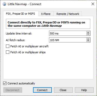
Well then the setup is pretty straightforward. Make sure LNM is running and then select the “Tools->Flight Simulator Connection…” menu.
Then on the window that pops up make sure the “Connect automatically” checkbox is ticked. (You can also tick the “Fetch AI or multiplayer aircraft” box is ticked if you want to see AI traffic on the map, multiplayer is currently not working and needs Asobo to fix it AFAIK). Then click the “Connect” button.
You can now fire up MSFS and LNM should connect automatically to the sim whenever it starts. Assuming this all goes to plan you will now be able to see your aircraft’s icon on the LNM map.
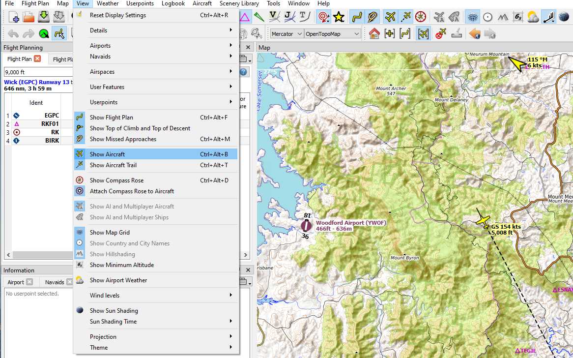
Make sure that the option to see your aircraft on the map is enabled - the “View->Show Aircraft” option must be highlighted.
To use any flightplan you create with LNM in MSFS you must export it from LNM in the correct format. Use the menu option “File->Export Flight Plan as MSFS 2020 PLN…”. Then you will be able to import the resultant *.pln file into MSFS on the World Map page using the LOAD/SAVE menu option (Space Bar hotkey).
The Xbox release version on the 27th has a detailed world map with cities which are also available during the flight. Not long to wait now.

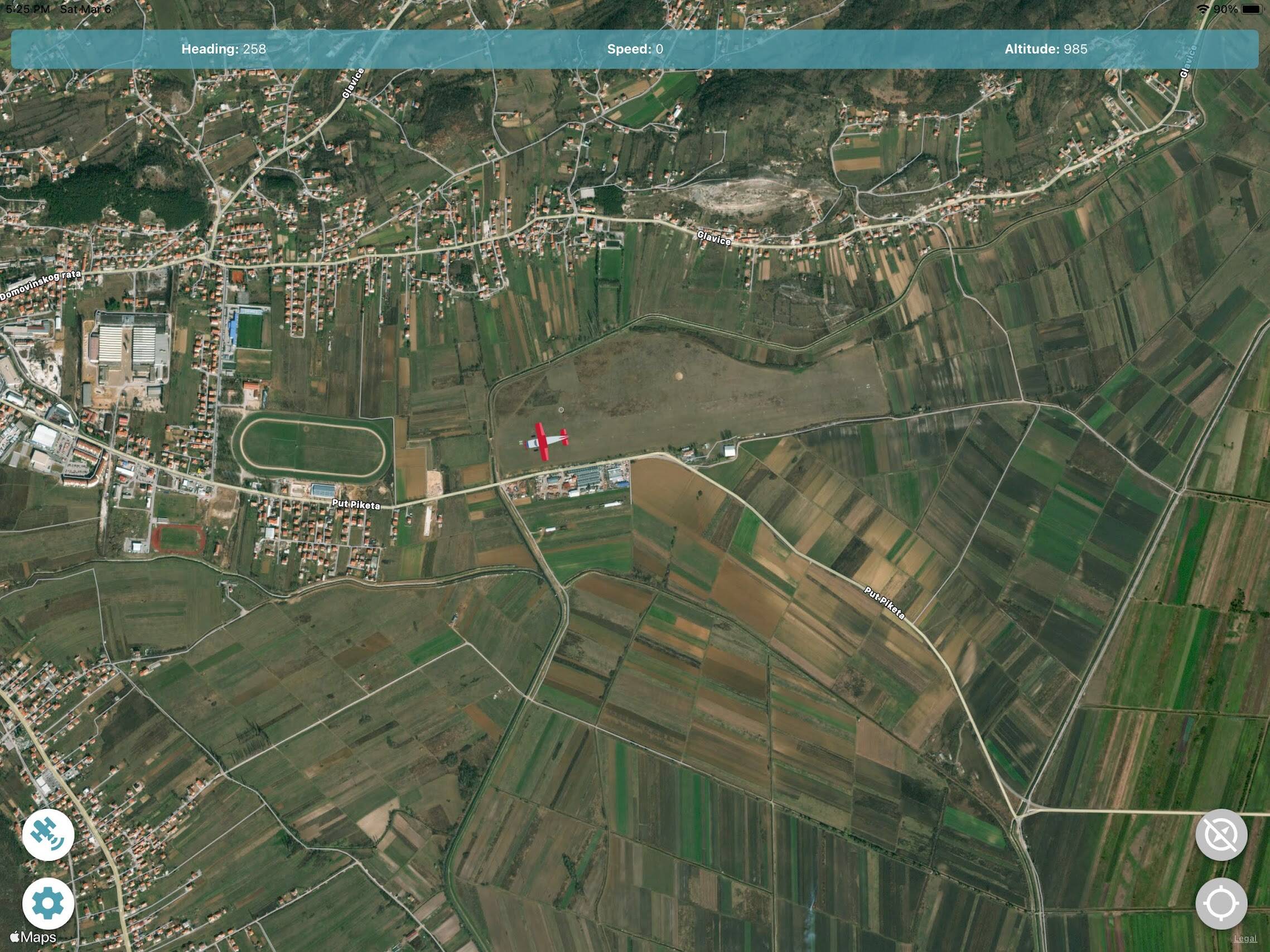
I use this one that lets me display a moving map of where i am on a phone or tablet:
I am glad you liked my suggestion on using Little Nav Map. As to how to get a flight planned out there and play it in Microsoft, its a little more complicated, and I may not have enough space here to fully describe it!
But in essense, you create a flight plan in Little Nav Map, setting a starting airport and an ending airport, and waypoints in between. Then you export the flightplan in MSFS flight plan format, and load it up in MSFS. The autopilot (if you have it) will then show your plan, and can fly the plane once you have taken off. Little nav map will show your position on the map whilst you fly.
Note you do have to make sure LNM has your MSFS scenery loaded. this is done by:
1st: Menu ScenaryLibrary → Microsoft Flight Simulato
2nd: Menu ScenaryLibrary → Load sceneray library, and makign sure you have selected your packages path.
This step will pull in all the airports, and scenary from MSFS, so runways, taxiways and gates are accurately drawn on the map. You will have to repeat loading the scenary whenever a new update (especially world update) is installed, or any community/official third party stuff is installed, in order to keep it up to date.
If you are finding this a bit difficult to folow, and it is a complex program at first! My advise is to look at youtube videos explainign how to use it. There are plenty, this would be easier than following some steps someone has written on a forum, as you will be able to see it directly. And spend some time to learn it. Its really worth it!
Most importantly… have fun!
Hi @E1ephant42 , @SenseiLeNoir and others…
You are really formidable, and pedagogically very remarkable in your answers. I had a certain respect for this LittleNavMap, because I saw in the videos that it was a complex program, and I didn’t need so many features.
However, I can affirm that the program that has a lot, has also a little. What sometimes happens is that the little you need can be difficult to find in an “ocean of information”, as is Little NavMap.
When I downloaded and installed it, I realized that I didn’t know where to start; I spent some time analyzing the menus and icons. After all that analysis, I started making the simplest flight plan that could exist. With that, I started to see quickly to create another one with intermediate points. And in my previous post, I asked for help to be able to see the plane fly on the plane of my first flight plan.
E1ephant42’s help with his various screenshots were really well chosen and chained; of course following them in their content, they gave me results that I myself was amazed: after doing precisely what he said, the plane did indeed appear moving on the map, something that I did not expect at the first attempt; I was amazed that it turned out so extraordinarily well. Yes, E1ephant42, I was impressed by how easy it was for me to assimilate and put to work so quickly, something that seemed quite complicated to me. Sincerely, E1ephant42, congratulations on your EXCELLENT work. I am very pleased with how well you have done, I deeply appreciate it.
Thanks also to you @SenseiLeNoir, the meticulous description you give me is very good, but it does not fit what I want. What I want I have expressed in my previous post, but I remain grateful to you also for your effort.
And of course, thanks also to all the others who have made the effort to lend each one with their exposition of what they consider good and interesting, and…
Thanks also to you, @SavvySigma, for your several repetitions to my questions, I appreciate it. Naturally, very special thanks to @ArcanoPython931 for your huge conviction that I should download LittleNavMap because it was superior. You were right, and you were not the only one. Special thanks for that. And…the first to reply to my post “how to identify cities in flight”, I mean “@Clayiscoast9”, you mentioned me several things to take into account, I even mentioned also Navigraph and even, LittleNavMap. For the record, that at that time, my interest is that you fly over cities without being able to identify them, that’s what I meant; then, my interest (since that information that I requested did not exist, was deriving to the programs to create flights.
Anyway friends, to all of you, and also to those who I do not mention but who made an effort to help me: thank you very much to all of you,
Kind regards from my heart: Delfín
I have been using the FS Map Tool with both an iPhone and iPad, its very easy to use and you can quickly zoom in and out to the level of detail you need. Its attraction for me is it’s simplicity.
Hi @BRITinUS
Could you be a little more explicit? To say that the program is characterized by its simplicity, that is to say very little. If you have used it for some time, I suppose you know its most important characteristics. Since you’ve taken the trouble to inform me, do so with more information.
Among various other features, does it allow you to draw a flight plan?
I await your clarification
Regards: Delfiin