How do I determine the actual elevation of the ground / terrain I am flying over? Any way to switch from sea level to ground level? Knowing sea level elevation doesn’t help much if you are flying in mountainous terrain at night or bad weather.
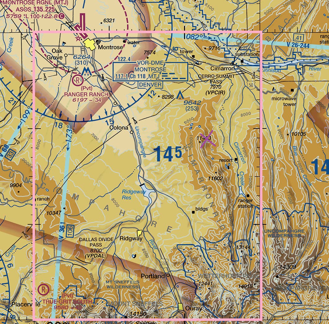
I generally don’t like flying over such terrain at night but let’s say I am flying at 17,500 at 17 DME off the MTJ 120 radial. Below me is terrain that is 10,000+ but does not exceed 11,500. With my altimeter set to the nearest available I know I am very roughly 6,000 to 7,500 AGL. Note that the MEF (the box I highlighted in pink) is 14,500 MSL. As long as I’m flying above this when flying in this box I will be fine no matter what.
1 Like
Each aircraft has its own attributes with regard to this ability.
Heads Up Display
However, the games Heads Up Display always indicates the elevation above Mean Sea Level called QNH. I’m not aware of any “switch” to change this.
Radar altimeter instrument
Many aircraft have a separate instrument called a radar altimeter that always indicates your elevation above the ground.
Barometric altimeter instrument
As apposed to the barometric altimeter that can show elevation above Mean Sea Level or above a particular airports Field Elevation (QFE - adjust the Kollsman knob to cause the altimeter to read zero).
Use radar elevation in bm98/FS20_HudBar: Display essential MSFS Information as Bar at the bottom of the primary screen
OK sounds like I’m looking for “Radar altimeter”. How do I find it in game? I mean I know on Instrament panel, but only some planes? Always on or toggle? Just starting so only have basic aircraft. Say Airbus A320 or F18 Supper Hornet.
Thank you. So I’m guessing you getting the elevations off the map (lower right corner 10,000 - 14,000 feet, right? That works if there is no gauge, but then my question is how do I access the map?
Thanks but I don’t have or can’t find bm98/FS2
Check the “MORA” in your briefing (minimum off route altitude)
I use SkyVector. They have VFR and IFR charts.
OK SkyVector . Thank You Very Much !
Yes, only for some “planes”. Usually the developer only adds the systems, like the radar altimeter, that are installed in the real aircraft.
It is also within the developers ability to have these instruments toggle on or off.
These are both very sophisticated aircraft with reasonably realistic systems modelling. Probably not good “starter” aircraft! But, since you asked, I understand these both have a radar/radio altimeter that are on at all times. Unfortunately, I’m not familiar with either of these aircraft.
INDICATING
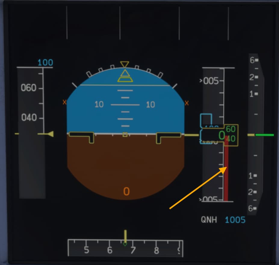
The A/C height data is displayed on the PFDs for heights less than or equal to 2.500 ft. The altitude is also shown by means of: – a red ribbon next to the altitude scale (below 500 ft), – a ground line rising on to the pitch down area (below 300 ft).
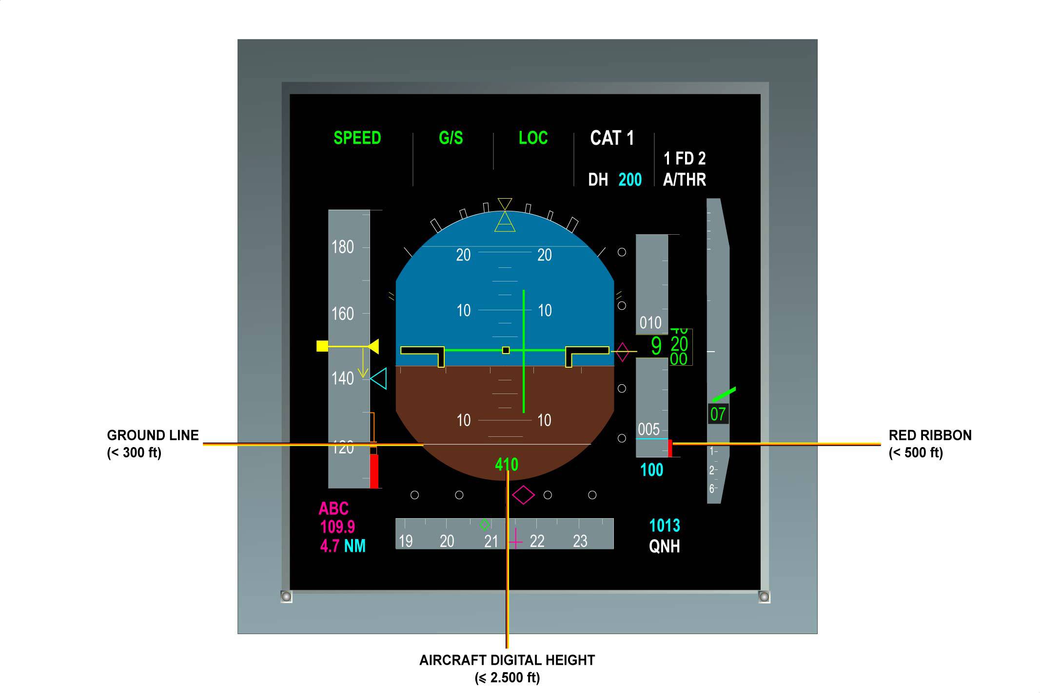
A320 indicator is a red ribbon.
@ Twodogzz,
OK, as I understand it. On the A320 in your first picture the green 410 just below the ground line indicates the planes actual height above terrain up to 2500’ at which point the reading disappears. So basicly a proximitor meter. Is that close?
You’re probably right about not starting out with flying those two, They were just the two that came to mind. I actually cut my teeth on the Cessna 172, but didn’t low it would have the radar altimeter. Really probably should have started with the DC3 but if I had I believe I would have given up right there. Like hearding goats on ice trying to get that hunk of metal off the ground.
Once again a huge THANKS to everyone ! A great help from each of you.
Yes, close enough!
Not many General Aviation aircraft have radar/radio altimeters.
Here are some details I found on the internet!
Fixed-Wing GA Aircraft (with Radar Altimeters as Standard)
- Cessna Citation X
- Cessna Citation Sovereign
- Cessna Citation Latitude
- Cessna Citation Longitude
- These business jets include the Garmin GRA 5500 radar altimeter as standard equipment (Flying Magazine, HeliHub.com).
Rotary-Wing GA (Helicopters) with Standard Radar Altimeters
-
AgustaWestland AW119Kx Koala
- Equipped with the FreeFlight RA-4500 radar altimeter as factory-standard (Helis.com).
-
AgustaWestland AW169
- Comes with dual radar altimeters integrated into its standard avionics suite (Wikipedia).
Summary Table
| Aircraft Type | Aircraft Models | Radar Altimeter Installed |
|---|---|---|
| Fixed-Wing (Business Jets) | Citation X, Sovereign, Latitude, Longitude | Garmin GRA 5500 (standard) |
| Rotary-Wing (Helicopters) | AW119Kx Koala | FreeFlight RA-4500 (standard) |
| Rotary-Wing (Helicopters) | AW169 | Dual radar altimeters (standard) |
Why These?
-
Garmin GRA 5500 for Fixed-Wing Jets:
Garmin’s first all-digital radar altimeter, offering high altitude accuracy and advanced reliability. It was selected as standard equipment in several Citation models (Flying Magazine, HeliHub.com). -
FreeFlight RA-4500 for Helicopters:
Specifically chosen by Finmeccanica (now Leonardo) as standard kit for the AW119Kx, integrating seamlessly into its avionics (Helis.com). -
AW169’s Dual Radar Altimeters:
This advanced rotorcraft includes dual radar altimeters as part of its sophisticated avionics suite (Wikipedia).
For Other GA Aircraft
Many GA aircraft (especially piston singles or turboprops) do not come with radar altimeters as standard. Instead, radar altimeters are commonly added via retrofit—particularly for operations requiring Part 135 or CAT II ILS capabilities (ICAO, Microsoft Flight Simulator Forums).
Thanks So Much … Very Helpful
Listing of available craft Radar Altimeters equipped is exactly where I was heading.
Radar altimeter won’t solve your question. A radio (radar) altimeter only indicates the height above terrain that is directly below your aircraft, especially over uneven terrain it is not useful. Neither can you reference this to obstacle and terrain heights on charts. If there is a high obstacle or a cliff ahead you won’t see it coming on the radio altimeter ![]() .
.
The reason complex aircraft have radio altimeters is for Ground Proximity Warning Systems (GPWS) situational awareness when on approach and for low visibility landings (CAT II and CAT III) the approach minima is referenced to radio height for such landings, furthermore the autoland system uses radio height. It is never used for navigation.
In real world, all terrain, obstacles, minimum flight altitudes etc. are indicated above mean sea level. Therefore you should set your altimeter to QNH of the nearest altimeter setting source (airport) and fly above those charted altitudes. As soon as you land your altimeter will indicate field elevation.
When setting QFE, the altimeter reads 0 ft when on the ground, this is not very common to do. Some airports might give you QNH and QFE (and for take-off you could just set the altimeter to 0 ft of course), problem here is again that all terrain and obstacle heights on the map are above MSL.
Unless the area is really flat, with QFE you don’t really know what your height above the ground is, you only know your height above the landing surface. So not very useful outside of very local flights (staying in the pattern).
So unfortunately the only way to tell your height above the surrounding terrain is to set QNH, look at your altimeter, look at the map and subtract the height of terrain or obstacles from your altitude. Radio altimeter only tells you what is directly below the aircraft, you can’t navigate using that.
And to make it more complex, the altimeter only reads correctly at standard temperature, when it is warmer you will be higher than indicated (which is safe at least), but when colder you will be lower and you need to correct for that as well.
“From high to low, watch out below”
Also applies when forgetting to update the altimeter to the nearest QNH when flying from an area of high pressure to an area low pressure. In all casses the altimeter reads correctly (field elevation) on ground with QNH set, nomatter the temperature.
2 Likes