Paperback, used but in good condition. Eight dollars. Boomshakalaka. 
We’ve experimented with POIs for our Skytours, and they work fine over longer distances, but I agree with the others that within an airfield boundary POIs would probably overwhelm.
Will the Kenley scenery include any structures outside the airfield boundary, such as the Camp “B” and “C” operations centers or “Sunnycroft?” Nag and I are preparing our next tour and marvel at how little some areas around Kenley have changed since 1940 while others are unrecognizable!
— PW
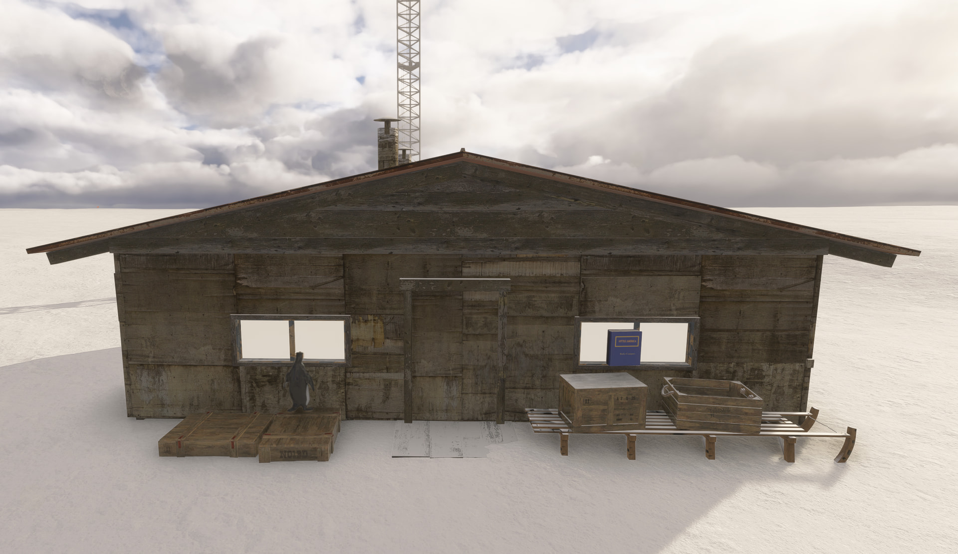
The Byrd’s Little America Antarctic scenery from DeadReckoningSims has a unique take on this: at various points of interest they have placed a blue “Little America” reference book. Open the book, and there is a QR code which will take you to a website with relevant info.
I like the idea of using signs, plaques, nameplates, books and other objects …especially if there is a way to link them to websites or other resources with more details.
Ooh. That’s an elegant solution! The points could trigger an audio tour, too.
— PW
If you aren’t already familiar, this is fantastic for audio narration of POIs as you fly over them: https://bushtalkradio.com/
Nice idea, though not everyone has a smartphone with the ability to scan a QR code.
Hi all, thanks for the thoughts and suggestions.
@MeusMagister @Pilotfirst9999 On the Kokoda Track experiment, I am away at the moment but if anyone would like to try it out let me know and I can make the file available when I get back - would be great to get some early feedback.
@SmotheryVase665 @Pilotfirst9999 I take the points made about using POIs in the confined area of an airfield, and was also wondering about some of the SDK limitations.
On Kenley, each of the buildings will have an RAF regulation sign on the wall telling you what it is, so from a walk around pov that is a start.
@Pilotfirst9999 And I will log the idea of a trail and treasure hunt!
@MeusMagister I will check the copyright on the airfield plan and if we can publish it as part of the User Guide then that would help I think, along with an index of building models.
@PeeweeAndNag On the site scope, everything within the footprint of the airfield is covered, including the two Victorian villas. Sunnycroft was a domestic home just outside the airfield boundary and we were trying to identify the site a couple of weeks back as part of deciphering arrangement of the Parachute and Cable system. I think I know where it was but the original house was demolished and replaced after the war.
@jjhenry5 thanks for the reminder about bushtalk radio. I have not run it for a long time but it is another way of presenting the material.
@OneToBeamUp3871 thanks for the pointer towards the Antarctica scenery, I will have a look at what they have done. A QR code itself feels a bit anachronistic but picking up on @Pilotfirst9999 's thoughts about noticeboards etc, there maybe other objects tomumb something into - like a draughts board or a telephone. Give the amount of research we have done I could imagine every object have a “story” attached to it although might have to be a v2 update project!
One final question for anyone still with me. How would you feel about a User Guide created as a set of webpages that could be open on a second screen, as opposed to a pdf file?
I prefer pdf. PMDG have that system and i don’t find it as user friendly because I prefer to print stuff of rather than have multiple screens which I don’t have the space for.
Works for me, as I have 3 displays, with only one being used for MSFS.
However, not all users have multiple displays. In the 2026 Navigraph survey, for example, only 30% of respondents have “several displays”, though 42% say they have a tablet:
The benefit of a web approach is that it can be - if designed well - much more dynamic and immersive than a static book-like pdf document.
One could perhaps have the best of both by having a website design in a way such that the user guiode can be printed as a pdf for those that want the pdf version.
Edit:
I’d be happy to test this 
A Dornier crashing through your roof will have that effect. 
Nag and I searched for Sunnycroft, too, and found it here, although as you said, it’s not the original house. The wrecked home is also visible in the August 1944 aerial photo series available on historicengland.org.uk. Gosh, I’d love to know what it looked like before the raid. I wonder if the current post box and nameplate are original?
We found some photos of one of the Dornier’s crewman’s family visiting Sunnycroft years after the war. Of course, we didn’t bookmark the website, and now we can’t find it. Drat!
I suppose we should say “we think” we found Sunnycroft, as it’s always possible that another home with the same name was built nearby at a later date.
Our next Skytour will feature RAF Kenley and sites associated with the Battle of Britain. We’ll start at Lydd and see the Chain Home stations at Rye and Pevensey, the GCI station at Wartling, the Observer Corps post at Beachy Head, and the Chain Home Low station at Truleigh Hill. We’ll then retrace 9/KG.76’s route from Beachy Head to Kenley. From there, we’ll peek at Croydon and the heavy anti-aircraft battery at Chadwell Heath before turning west to Fighter Command HQ at Bentley Priory and 11 Group HQ at Uxbridge. There will be a few surprises, too.
We’re almost ready to publish Part One, so we just need you to…you know…finish Kenley.
(Totally kidding. Good things—great things, in fact—come to those who wait.  )
)
Just to say I think Croydon airport is such an important airport historically from first flights in 1920 to commercial aviation developments to its importance in WW11 and development of “the tower” until closure in 59.
It really needs someone to love it and develop it from its art deco facade to having the runway almost on the doorstep.
There are many old videos of aircraft taking off so i would think it has quite a lot of material to draw from.
It was also the airport from which aircraft took off to defend Kenley on 18th August.
Redwing did Croydon in 2020 I think I saw somewhere it’s on their list for 2024
Thanks, had a peak at that but it is only for 2020.
Its not super realistic but it works ok for me in 2024.
Thanks. Not being a tubeliner driver I didn’t realise PMDG used that system.
Good point. Once it is written, I think both options should be possible.
The idea sprang from “vibe coding” some alternatives to docs for my non flight sim work and changes to the TMD website.
And I will tidy up the Kokoda file and let you know when it is on flightsim.to.
Judging from the photos I think it definitely does!
I was looking at the photos of the visit by the crewmember’s family, and I have a suspicion that the house have been rebuilt again since as the layout did not seem to align to what you can see on Google Earth / Bing Maps now.
The photos, along with details from 18th August are here.
Sounds like a great route for the tour - we will get out act together and sort out the missing piece for you!
Croydon is in our provisional civil airfield collection along with
- Weston-super-Mare, part of a larger project with North Somerset Council
- Stag Lane and Hatfield aerodromes; homes of De Havilland
- Filton, home of the Bristol Aeroplane Company
- Clifton Hampden, the private airfield of Major George WG Allen MC FSA, who took over 2000 air photos from his De Havilland Puss Moth that were interpreted by OGS Crawford, “the father of aerial archaeology”
(@PeeweeAndNag Allen and Crawford might be a candidate for a Skytours itinerary as their work covers some of the most iconic archaeological sites in the south of England).
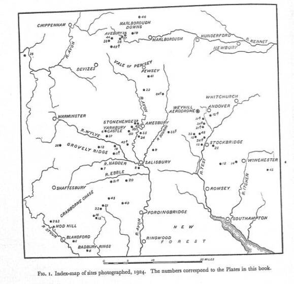
That’s an excellent suggestion. Crawford and Alexander Kieller’s book, Wessex from the Air, details the sites they photographed in 1924 using A DH.9 based at Weyhill.
I’ve got a copy of the book somewhere, but there’s a copy on the Internet Archive.