That´s realy great. Thank you!!!
A lot of effort to add this. Not sure.
@Haddock314945 No idea what’s going on there. I can see 76 stock airfields prefixed with LF with a number in MSFS data. I see the same number on my Linux development and Windows test machines.
Path name does not matter. LNM has to read everything not matter if it contains spaces or special characters.
Can you see the airports on the map?
Problem solved !
I don’t know if it was on by default or if I had clicked it by mistake, but “Use Navigraph for all features” was selected in the “Scenery Library\Navigraph Cycle 1801” submenu.
Yet in the “Scenery Library” menu, the only tick was near to “Flight Simulator 2020”. In term of UI, that’s super confusing to be honest. Anyway, thanks for the help, it’s solved now. 
And thanks for this very useful software.
(On another subject, I completely support SoloTwo42’s request.  )
)
Ok, not a huge deal. Maybe a way to manually input altitudes into the flight plan for printing? Not sure what the remarks section is for but I can’t figure out how to manually input text on that section, maybe handwriting is the answer lol.
You can add remarks for the flght plan. Nothing to enter if there is no plan.
For manual altitude input: You can also add remarks to each flight plan waypoint. Just right click in the map or the flight plan table.
1 Like
Nice that it is solved but the problem would not have appeared if you read the dialog which shows up if you choose the navigraph only mode. 
I add these messages for a purpose.
2 Likes
So it was off by default ? Then I might have clicked it, I don’t remember doing it (or seeing the dialog) but I’m not getting any younger so that’s probably what happened.
Thanks !
Hey @albar965
since live weather relies on data from Meteoblue and I found the meteoblue website quite a good and consistent source for inflight weather as observed in the sim, I like to check the website for preparation to see how the different winds and cloud layers are to pick a good altitude and calculate fuel.
Now what I miss is to have a simple hotlink from LNM to the website with the coordinates prefilled.
So I have the following idea:
Add a Settings item “external links” where one can maintain a list of entries with a “name” and a “link” where the link supports placeholders for lat/lon (in decimal) and maybe zoom (if that’s somehow standardized).
So when clicking on an item in the flight plan or on the map one would have a submenu in the context menu of it containing the names of the external links as they are defined in the settings. When selecting it, the browser is opened with an URL created from the predefined link but with the variables substituted.
Example:
I create two entries in the settings with the link containing variables for %zoom%, %lat%, %lon%:
Name: “Meteoblue Low Cloud Layer”, Link: “https://www.meteoblue.com/de/wetter/webmap/beta/#coords=%zoom%/%lat%/%lon%&map=lowClouds~hourly~auto~sfc~none”
Name: “Meteoblue Wind 850mb”, Link: “https://www.meteoblue.com/de/wetter/webmap/beta/#coords=%zoom%/%lat%/%lon%&map=windAnimation~coldwarm~auto~850%20mb~none”
When clicking on Paris-Orly and selecting the “Meteoblue Low Cloud Layer” entry, the browser would then be opened with the link, for instance like that:
https://www.meteoblue.com/de/wetter/webmap/beta/#coords=10/48.8/2.5&map=lowClouds~hourly~auto~sfc~none
That would help a lot to get a quick overview without scrolling on the various sources and it would support basically any website that supports Lat/Lon in the URL.
Right now I can copy the coordinates from LNM but this format is not supported on many websites and needs multiple steps even if it does.
Cheers
1 Like
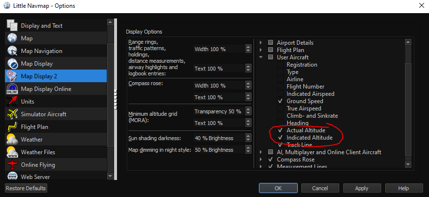
Since installing the latest version (from about a week ago) I noticed on the user aircraft label there are two altitudes displayed, the second being IND. Is there a way to remove this? Just trying to get my user aircraft label a bit smaller. Thanks!
Alex,
First off, from one developer to another, OUTSTANDING piece of software you’ve written with LNM!
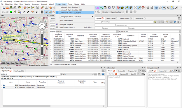
Second, in the attached screenshot, where is LNM getting the AIRAC Cycle for x-plane? I currently have cycle 2011 loaded in XP’s custom data folder but LNM is indicating cycle 2010.
Regards,
Robert
1 Like
Forgot to attach the screenshot…
Thank you for the kind words!
You have to reload the scenery library in LNM after updating. Navigraph can also update the LNM navdata directly. Do not forget to close LNM before updating.
@Coppersens: I’l think about it but I’ll stay away from highly configurable solutions since it makes the program incredibly complex and hard to maintain.
1 Like
Totally fine, me as a developer I can understand the concerns since LNM is already very complex in terms of configurability.
Maybe there’s some easier solution for my issue, I’ll have to think about it.
Possibly making the existing feature to copy coordinates configurable in terms of what format is copied to get decimal lat/lon values would help, since I currently can’t use the DMS/compass format to automate the lookup in the browser.
EDIT: Oh my, there’s already such an option! You’re a genius and I’m blind ![]() disregard the above mentioned!
disregard the above mentioned!
Hi, would you like to share the solution (and option), please? thanks
Great… that fixed that issue. But I do have another minor one. Even when I’m using MSFS2020, the flight is logged as XP11 in the logbook. All of the other data points are logged correctly with that one exception.
Robert
In LNM in the options, there is a section for Units. There you chan choose the format for coordinates to be “Latitude and Longitude with sign”.
If you want to have a quick way to call another URL with these coordinates, I did the following in Chrome:
- Install the Extension “Aliaser” (it supports quick search with multiple parameters which Chrome doesn’t out of the box)
- Add a keyword to the extension (via the extension button) with the following parameters:
name “w” and URL “Wetterkarten | Live Satellitenbilder & Regenradar - meteoblue” - Copy any coordinate from LNM map by right-click → More → copy coordinates
- Go to chrome, type in the address bar “a(space)w(space)(ctrl+v)(enter)” and it opens the meteoblue map at the same location as selected in LNM
This way you can also create a different alias for skyvector, bing maps etc. the coordinates in the URL need to be replaced by %s and the URL needs to have latitude first, then longitude.
Sorry for getting a bit OffTopic, but maybe someone has the same issue ![]()
1 Like
This is amazing. Thank you
Out of curiosity, is there a way to have little navmap read two different instances; e.g. if two people are playing, little navmap sees both?
Nope since LNM isn’t capable of displaying multiple flight plans etc.
If you’re flying on a network like VATSIM or IVAO, LNM can display the other aircraft on the map.
You can check FlightEvent tracker, which pushes your data to a server and you can see all players that have this running on a common map. But the functions there are of course nowhere near to what LNM has.
1 Like