I just changed the time because changing back time here by around 10 hours currently remains on the same date as I’m in the UK.
It’s not a perfect solution. It seems I can only go back to around 1800-1900z, so we get the weather model back from that time, so it’s still outdated technically. But what’s nice is it means if it’s meant to still be overcast cloud, where as the next day it is forecast CAVOK, it will still be cloudy rather than clear skies.
No worries! Like I say it’s by no means a perfect solution, but it at least means we can have more accurate weather than it just switching to the model of the next day which can be drastically different!
There is no live data to get. At least not in terms of what Flight Simulator needs. I think folks mean the latest observations, and Flight Simulator does indeed get this data, downloading METARs to provide surface winds, temp, and pressure at the airport. But if you want winds aloft or enroute weather, then you need a forecast model. Flight Simulator has to create a model of the entire volume of the atmosphere. There’s no live data for this, so they use Meteoblue’s model instead.
The model has advantages and disadvantages. METAR reports are only available for airports - a 100 percent “live weather” system would have no weather data at all for remote areas - over the oceans or basically anywhere without a nearby airport.
The model covers the entire world. No matter what your location on earth, the model should have the predicted weather for your current location in the sim world (airport or not).
METARS only give current conditions on the surface. They contain no information for upper atmospheric conditions, winds or temperatures. And the range of a METAR report is only valid for just a few miles radius around a given airport. The model has data from the surface to probably 50,000 feet above the surface, at multiple levels and unlimited horizontal extent.
METARS do report clouds - but often only when they impact whether the airport is VFR or IFR - if VFR There might be a solid overcast at 6000 feet, but the METAR will often report CLR. Likewise for visibility - if the visibility is at least 6 miles, the METAR will simply report “P6SM”. It might be exactly 6 miles - it might be unlimited. There is often no way to know.
The disadvantage of the model is that although it will contain much more information about the state of the total atmosphere both surface and aloft, that any METAR- based system could ever provide - it is a forecast - and as such, the weather may not correspond to actual surface weather. Sometimes it is very close - sometimes not.
But, to be “close” the model has to give the right predicted weather for a specific location and a specific time, and it is the time part where things appear to be going wrong with Live Weather far too often.
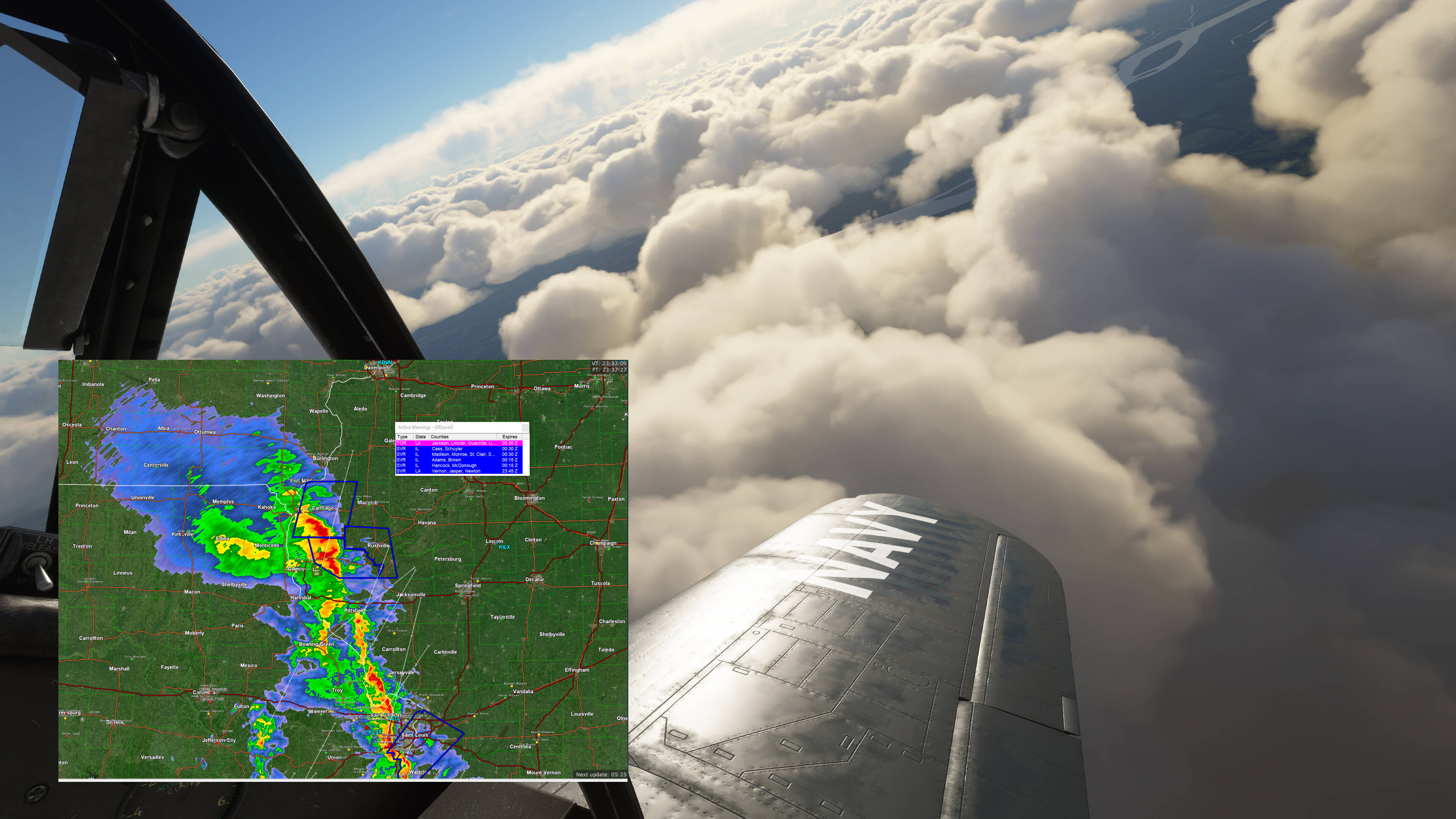
So at least the simulator made an attempt at storms and building cloud cover where they actually and currently are, but yeah, it came up a little short on the sky conditions: no rain, no overcast, and no real depth to the clouds. Let alone severe winds and turbulence.
I don’t expect the simulator to get the individual thunderstorm cells, especially in more subtle environments where they’re rather random. But this was a large extratropical cyclone and frontal system that was handled well by forecast models, so I think it could have done better than this.
I managed to capture interesting footage just now. It shows the sim transitioning from the current model which sees the airport at CAVOK, to the new forecast model for tomorrow which is forecast CBs and cloudy weather.
So what I guess this means for us as simmers is that even though you can manipulate the time and go back to the previous model eventually it will change back to the next day model at whatever time that is on that day, today for me it’s around 20:04z
That genuinely makes me wonder if what they’re doing is not replicating cloud cover, but simulating the atmosphere. As in, they set atmospheric conditions like wind, pressure, temperature, dewpoint, then create updrafts and downdrafts based on scenery, and out of all of that they create clouds.
So exactly the same thing happened to me yesterday that happened a few weeks back with the future weather/outdated weather bug. Roughly the same time of day also, about 2000 EDT real time (0000Z). This time though it happened midflight.
While enroute, what was scattered clouds became clear and the wind changed. When I finished the flight, the world map still showed future weather corresponding to 0900Z the next morning (I started the flight with future weather), but after closing the sim and relaunching, old weather corresponding to around 1200Z from earlier in the morning was showing, which seemed to match the weather change midflight. This is the first time I’ve seen this bug manifest while in the sim.
While the cloud coverage and rain, etc seem pretty accurate for me, I’ve noticed lately that the wind at KMSN appears to ALWAYS be 220/7 ish - I’m always getting runway 21 for every flight, even when the wind has changed a lot in the last week or so.
That is what they’re doing, but the simulator isn’t doing it. Meteoblue’s numerical forecast model is doing it. Those initial parameters go into the forecast model and it spits out where the clouds are. The simulator simply downloads this data and tries to display it. The clouds in the simulator are animated from generic patterns, probably just based off of relatively simple 3D noise patterns. What looks like an updraft is just a visual pattern being translated in the vertical direction. I haven’t seen evidence that it’s actually taking into account the scenery, or simulating convective updrafts. For example, when there’s a marine layer with dense fog, the cloud coverage is not confined to offshore areas, but is pretty much randomly distributed across the area, including over land where solar heating would have melted off the fog. It will also occasionally draw scattered cumulus on the ground when there’s not supposed to be any fog or low cloud cover. Even if there were fog, it’s the wrong cloud type, and is probably a bug somewhere in the weather engine.
For the sake of smooth transitions, the simulator probably shouldn’t be switching to an entirely different model run mid flight, like it appears to be doing for you guys when it downloads the next day’s forecast. It should just stick with the current model’s forecasts unless it actually runs out of model forecast hours. It shouldn’t do that either though as these models cover the forecast for a number of days, and your flight wouldn’t last that long.
I have felt it. Scenery does affect it, and so does transitioning from over land to over water, for example. So some of it is going on. Whether it’s right and realistic, that’s a different matter entirely. But one thing i didn’t notice (maybe cause i wasn’t paying attention) are updrafts under cumulus clouds.
Either way, i think we can all agree that the weather model is not there yet. It’s doing something, but it’s not doing it quite right. Just about the only thing that it does brilliantly is look great.
The numerical weather model itself is taking into account terrain, surface type and conditions. So mountains and the transition from land to sea will definitely affect cloud cover. But the model is on a 30 kilometer grid. So the weather won’t actually follow the coastline that well, and the weather won’t change much from peak to valley. The simulator just downloads those 30 km grid cells and fills them with a generic cloud pattern. So yeah, what I mean is the simulator isn’t doing it’s own additional interpretations based on the local scenery features, at least from what I can tell. It’s all rather broad and generic based on the weather model it’s using.
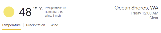
Just went to load a new flight from W04 (Ocean Shores Mun.) and selected live weather. It is currently clear, wind 070 @ 1kt. It has been cloudless here for 2 days, and is forecasted to stay that way into next week. For some reason, the sim thinks it’s raining with wind 220 @ 9kt. I’ll load my own custom weather to match real-world conditions in the meantime, but for now the live weather feature isn’t really useable IMO. @Jummivana if you could please forward this to the dev team we’d appreciate it.