Can we please have a map of the whole world that shows the DEM resolution for everywhere?
Asobo released one for WUII: USA showing the updated regions of the USA and their LODs:
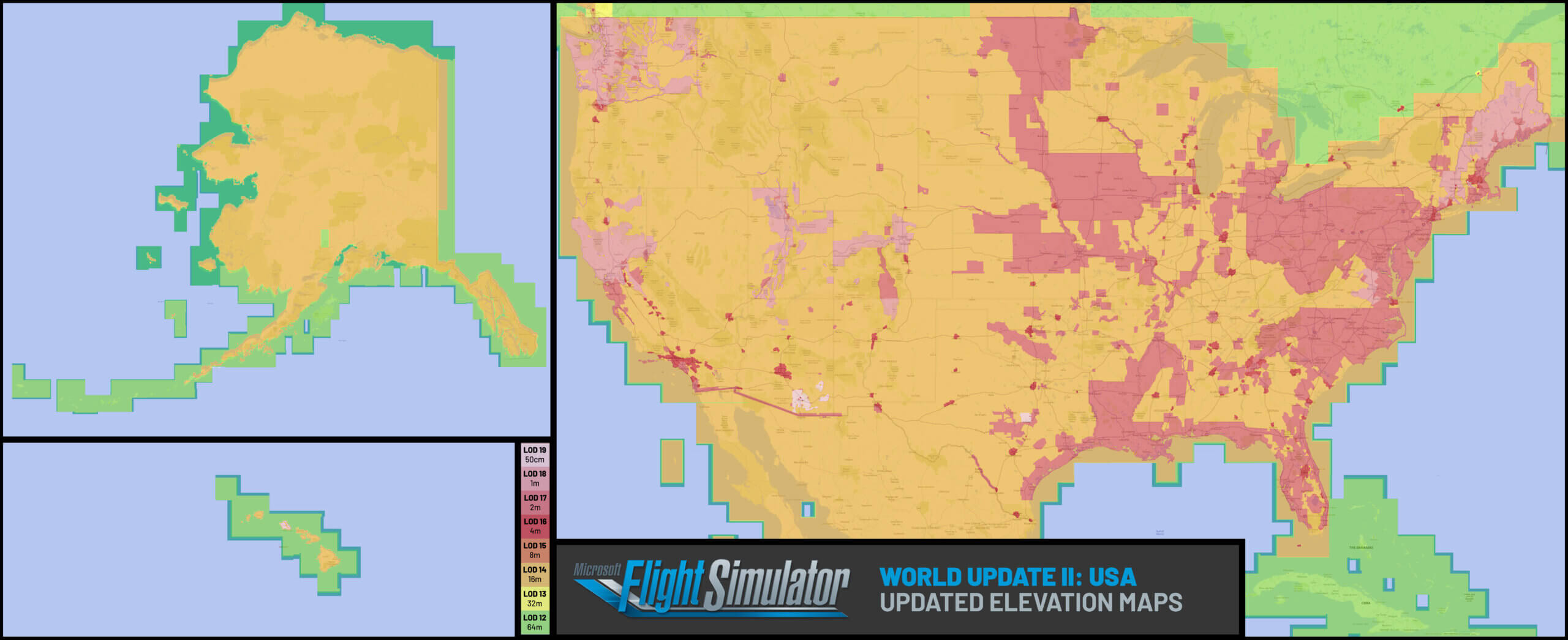
We can see the map also partially covers Canada and the Caribbean, which makes it look like Asobo might have the whole world mapped anyway!
To summarize:
-
It would be nice to see the improvements made by world updates. (Asobo should be showing them off!)
-
As it is now, we are left guessing where has been improved and by how much.
-
It would enable us to plan flights based upon areas that have beautiful high LOD terrain quality e.g. Washington state and Mt Rainier using the WUII map.
-
Many third party developers are releasing DEM/mesh DLCs. It would be helpful to know how much of an improvement they’d be and whether it’s worth getting them.
1 Like
I totally agree with you. We need to know the mesh definition of each part and Asobo should improve a lot the mesh in many places. Alaska mesh is a must have.
1 Like
This is a great suggestion!
All kinds of “scenery quality” related information would be valuable: DEM grid size as mentioned of course, but also map/texture resolution, weather measurements distances and potentially others (maybe any TIN/photogrammetry areas, etc).
Visualizing how this impressive digital twin of earth improves over time would be amazing in itself, but it would also be a great tool for flight-planning inspiration.
Both as a map on the official website and as an optional overlay over the in-game world-map (potentially also incorporating changes made by third-party products), this information would be a great help.
2 Likes
Dont forget Hawaii.. but back to the topic - in almost each developer stream there is DEM map of the area bneing updated (lastly for example UK, or Austria/Switzerland/Germany). So after almost 2 years from this topic - Is the DEM map anywhere to see the DEM in the whole world? Thanks.
1 Like
Surely there must be an internal reference map of the current “state of the world” for MSFS 2024?
3 Likes
Still nothing. A digital twin of earth with no actual definitive guide to the highest resolution locations. 
You’d think that would be useful as a key selling point of the sim as it showcases one of the best aspects of the DT in the highest possible quality currently attainable, but no, we’ll just let people stumble across it randomly.
1 Like
I was just thinking the other day that I would like to see this.
2 Likes