That is correct
Well, at least it matches METAR  Maybe we should not expect more than matching METAR?
To me it would feel more believable without any of those fog layers. Not accurate but feels alot more believable.
Well, the METAR was saying 3 layers: Few, Scattered, Broken and none of those were displayed. So it did not match, maybe only visibility was taken in account.
Yes, but if they injected 3 circles of layers it would look even more bad right? They not injecting any clouds from METAR besides Fog. But in su7 they have changed the clouds to not interfare with METAR visibility. Correct me if i’m wrong here.
Yes, but I thought that all information coming in a METAR was taken in account, so looks like it is not the case, they are just using visibility information and I think maybe when it says overcast. Few, Scattered, Broken are not taken in account at all ?
1 Like
Thats my thoughts as well. But i think METAR changes the clouds Meteoblue injects. But it never adds clouds. To me it feels like they have changed the complete rendering of clouds in su7 to be able to blend in METAR.
Tested much. Often the higher clouds match what i see on Meteoblue data. Lower clouds mostly not matches Meteoblue. Often insertet as broken instead of full coverage.
Ok, maybe you are right. So if part of the information that comes in the METAR is not rendered (Few, Scattered, Broken), it should not satisfy 100% of the expectation of people that are using it for VATSIM for example. If METAR says cloud layers are there, pilots using VATSIM should expect to see them when flying close form the airport isn’t it ?
Depends on what they actually needs from METAR to be able to use VATSIM. I think it’s important that Asobo tells us what information to expect from METAR and what information to expect from Meteoblue and where it should match what.
I think those using VATSIM already had the information they needed pre su7. Temp, wind and preassure.
But to me it feels like VATSIM should have adapted to MSFS sim weather and not the way around. Maybe have 2 platforms or make a complete new system that would have worked with MSFS at release.
Maybe created METAR from simvar values and report and use those to control the traffic.
Simvar shows temp, wind and preassure in real time. The visibility is just to start a flight on the airport and look or maybe the users of the sim reports the visibility to the atc controllers every 30min. This is how it works IRL. Observations of weather.
I can observe the weather in the sim. It always match my own observations. I observed your weather in those photos and i observed it doesn’t look natural.
1 Like
I’ve seen cloud types and layers missing even in areas far from any METAR station. This applies to sudden transitions as well. Something fundamental has changed with the weather engine since SU7 as evident by the recent popcorn bug. This goes beyond the simple blending of METAR, but it’s impossible to get any concrete info from Asobo to troubleshoot. Maybe they don’t want our help really.
One thing that I keep seeing in the recent screenshots is how similar the live weather cloud patterns look since SU7. Cirrus up above with cumulus down below and maybe a cloud band on the horizon. Like they are all generated from a preset with limited diversity.
4 Likes
I think the new more frequently updated Meteoblue data feed and METAR-blending is a big part of the problems we see. But none of us can debug whats going on. I know they also added that density slider. It’s many things that can be the issue. Impossible for us to help more than tell what we think about it and post screenshots.
2 Likes
Agree, exactly what i see too. The higher clouds are formed together and the bottom layer is broken. Always the same.
Pre su 7 i felt a random feel to it like real weather feel. I know what i will see now when starting a flight. Nothing special. Pre su7 i could get that feeling of a unique view of the sky that i never experienced before.
Just look at those threads that has posted screenshots since release. Since su 7 all of the screenshots looks mostly the same.
And do not tell me i’m just want the looks. I want the weather to feel real not be the real weather because that i know is impossible to get even with METARS included.
Even clear sky had a unique look to it. Clear sky is not always completely clear sky. I think it’s more rare to have it complete clear than not when METAR says clear sky.
5 Likes
Adding another example here that I have not seen mentioned. NEXRAD data is perfect to see what’s happening when METEOBLUE and METAR disagree  .
.
Others may have already mentioned this, but it seems like the METAR data should only be used to update the METEOBLUE model, but never to override it in the sim.
4 Likes
Well, there we can see the umbrella effect over METAR airports. I don’t see a way to blend it better though. METAR says no rain, Meteoblue says rain. What to do? I liked the more natural, realistic weather we had at release without any kind of weather changes/transitions to fit METAR. We should be able to toggle that thing off. Those liking accurate weather over airports turn blending on and accept the strange behaviour in weather with METAR and those liking 100% Meteoblue toggle blending off and accept it not be 100% accurate all the time. Easy to make everybody happy. Maybe those liking METAR also want to use the 100% Meteoblue weather sometimes.
Here is the rainwall that appears around those airports when they dissagree.

3 Likes
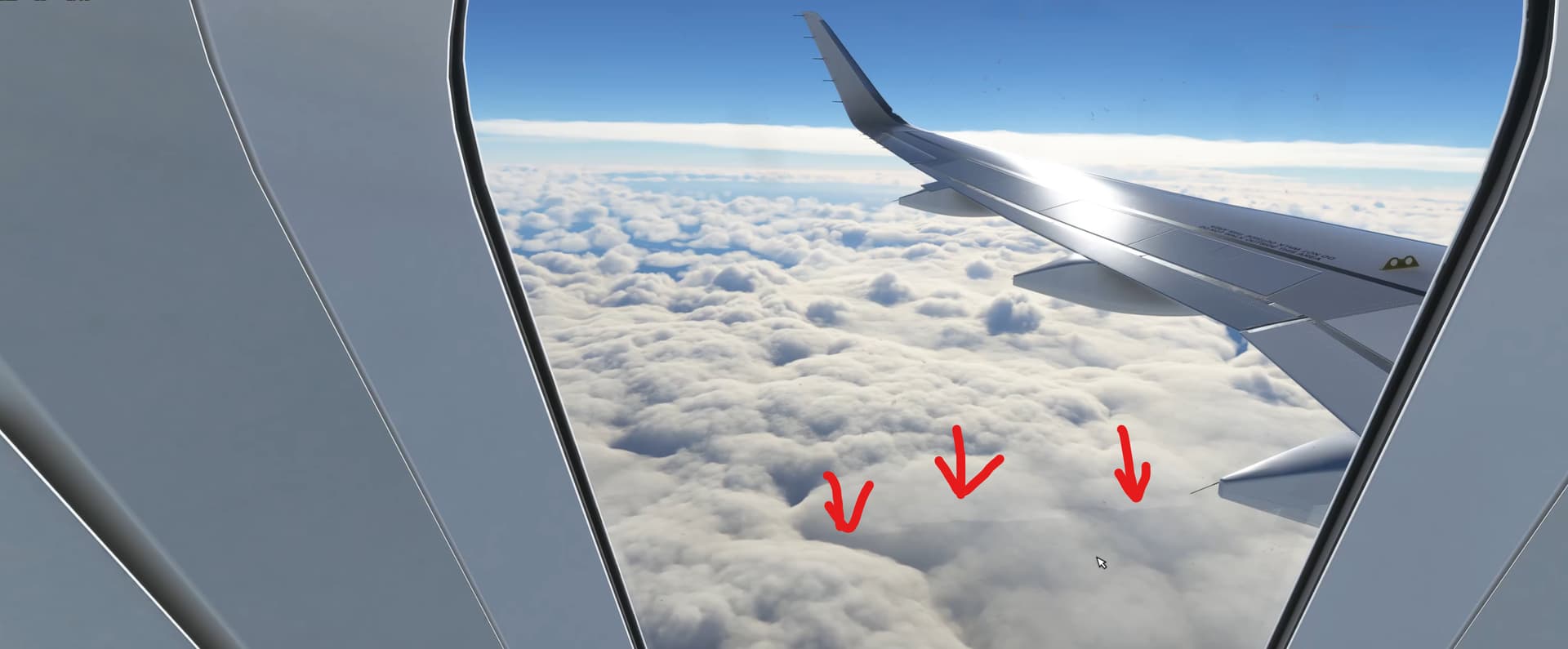
It looked like this. Amazing actually!

A second later it changed to this generic just broken apart clouds. Why can’t the clouds stay formed together? Server issue or METAR issue? This is the problem we have since su7. Fix it Asobo.

9 Likes
It seems like a lot of these posts are related to cloud formations. It’s highly doubtful that METAR is responsible for this. I think the MSFS weather system will continue to evolve and am totally pushing for updates to the wind contours (ridge/wave lift) as well as thermals and cloud formation. I also think it’s very important to have METAR weather match up to simulation weather, but only within a radius of airports. Smaller airport METARs are just automatic and won’t actually report cloud bases unless it’s IFR and in some cases not at all. They just report as 0000Z AUTO CLR. The three biggest problems with MetroBlue system were wind, cloud levels (base & top), and barometric pressure. The results were IFR 1/8mi visibility on a day with SCT030 reported on the METAR and even on MetroBlue maps.
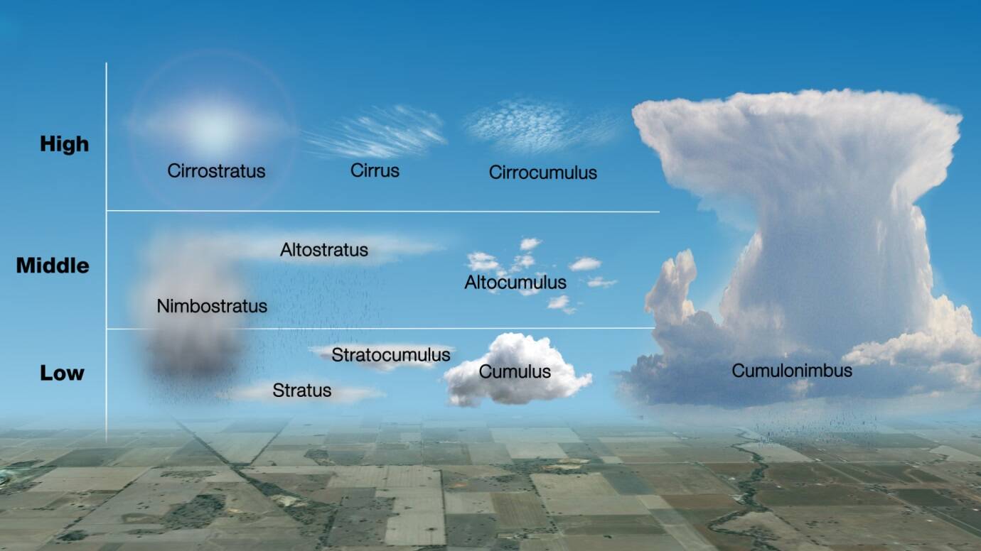
Cloud types more or less from left to right, coldest to hottest.
2 Likes
This is for me currently the most frustrating thing about the sim. The first 2 pictures remind me of the type of clouds we had when the sim was launched. Makes me upset and angry in equal measures.
5 Likes
Maybe, but clouds IRL doesn’t change from one second amazing and then the next second bad and generic. It has something to do with new weather system they use since su7. Never had those switches in weather pre su7. Those switches make me turn off the sim. It really destroys the experience.
4 Likes
Yes it was early in the morning here in Sweden at around 03:00Z. I usually get pre su7 weather at that time on day. I think it’s servers that can’t keep up with all of the users. Maybe it has heavy load. Who knows? Or some of the data gets corrupted. A thing i really know for sure is that the weather was more fluid and realistic pre su7.
I think it doesn’t matter how much energy they put into this new system with layers, cloud types and things like that if they not find the core issue with those hard switches in rendering.
They need to focus on that the data they get is rendered the same way all the time. Not switching between broken and formed together. I’ve seen this behaviour since su7 got released. Sometimes good rendering and sometimes a completely different bad type of rendering that makes every cloud formation be broken.
6 Likes
I would agree that cloud spawning is an obvious flaw, but it’s been around through all flight simulator weather. To avoid that, you can run a weather theme instead of live weather.
I can point to the Feature Discovery Series 2 & 3 for what they were using.
Feature Discovery Series Episode 2: Weather - YouTube
Feature Discovery Series Episode 3: Aerodynamics - YouTube
Specifically in episode 2 where they say they can create any cloud type and in Episode 3 where they show the wind adapting to the contours of the terrain. This is amazing and hopefully will be refined to have some sort of atmospheric compression factor. It’s seems somewhat linear. Another post has a pic of the proper form of ridge lift which I believe extends out into wave lift. The clouds have been updated to include what looks more stratus, but I bet you couldn’t find a screenshot of every cloud formation yet.
The original weather engine didn’t seem to pop weather in but had some major glitches. One of the more memorable ones being the severe unending rainstorms and random wind directions. I don’t mean random in a good wind shear way, just random directions. The endgame is properly injected METAR data where available and reasonably accurate cloud bases and precipitation elsewhere. All METAR reports provide wind and barometric pressure. I’ve looked at the Metroblue maps. It’s hard to believe the cloud levels, precip, and coverage don’t match up. We’re going to see working weather soon.
1 Like