Thanks, added to the list.
Deleted due to wrong thread
Inverloch Airport (YIVE), Victoria, Australia seems to be missing from the sim. 38.6125 - 145.7332
Visible on Google Maps, not on Bing Maps. Available on Flightsim.to
The airstrip is shown in Bing Maps YIVE on Bing Maps.
The airstrip is visible in MSFS as a grass airstrip. In order to get YIVE into an AIRAC update, the IRL owner of the airstrip has to submit the airstrip information to the proper Australian aviation office. Their updates are added eventually to an AIRAC. When the AIRAC is updated and distributed, then YIVE will be available in MSFS. Until then, the GPS coordinates can be used as a waypoint in an aircraft’s FMS.
Thank you for that information - interesting. Just goes to show that every day is a school day. Intrigued though - how does an airfield get an ICAO code without submitting their ‘existence’ to the relevant aviation authority? And, yes, I missed it in Bing maps so thanks for that as well. I failed to see it in the sim though and I suspect that I landed just to the North of the actual strip.
Has any of the above been confirmed as being added in to the sim yet, without resorting to Add-on’s ?
If you are referring to airports that were on the list at the top of this thread, yes. Hundreds have been added to the core sim since its release.
4 Likes
EHHA Amsterdam Heliport is missing.
Location: 52.414643, 4.804810 (or 52°24’52.7"N 4°48’17.3"E)
Group 6 heliports.
It is a small modern heliport located in the north west of Amsterdam, the Netherlands, in a harbour area known as the Westpoort. It provides parking space outside for four helicopters and hangar space for another three. The heliport was opened in 2005, aiming mainly at VIP transport and airwork.
Thanks. I’m going to hold off for now adding helipads and heliports to the list as almost all seem to be missing. Has anyone seen anything from Asobo on their plans to add them or is it going to be left up to the community to add them with World Hub? We are talking well over 15,000 locations.
Hi ![]()
Adding heliport is part of our plans, we are thinking about the good way to integrate them in the sim.
Have a nice day
2 Likes
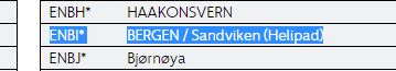
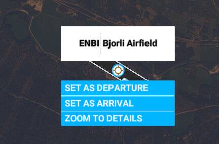
edit: reported to zendesk: Request #180252 ICAO wrong: ENBI should be ENLB
I’d like to report an incorrect ICAO, please and thank you.
ENBI Bjorli airfield in the sim should be ENLB. ENBI is in real life Sandviken helipad in Bergen.
Official source: Location indicators
![]()
2 Likes
Hi,
The airport for the city of Pasighat in India on the Brahmaputra river is not “physically” present in MSFS. In the World Map the runway and ICAO is displayed but when spawning anywhere on the airfield you can only see grass. There’s neither a runway, nor any airport buildings. Also the satellite image does not show the presence of the airport.
The airport was built after 2010, so probably the satellite imagery for that area is quite outdated.
ICAO: VEPG
Coordinates: 28°04′06.5″N 095°20′04.3″E
1 Like
How bout an EXTRA Airport that is in ERROR and SHOULD NOT be in the sim cause it doesn’t exist as it is shown.
SIM airport shows as: Ketchikan Airport (PAKE) (Which is in error).
|City:|Ketchikan|
|Elevation:|21 ft|
|Magnetic declination:|18.3° East|
|Coordinates:|56.2188 -131.48505|
PLEASE REMOVE FROM SIM AS THIS AIRPORT DOES NOT EXIST.
Thank-you (note also sent to Zendesk to remove this airport from the sim).
That isn’t correct, there is an airstrip clearly visable on satellite imagery at the coordinates you have given.
On skyvector, there is a power plant marked at this location, it looks like the airstrip is a private one. Probably owned by and serving the power plant.
The airstrip should stay in MSFS, just with a different/corrected name/ICAO.
Edit 2: Maybe ‘Tyee Lake Hydro’ for the name.
Edit 1: I found the power plant owner; Four Dam Pool Power Agency.
https://hydroreform.org/hydro-project/tyee-lake-hydroelectric-facility-p-3015/
It’s probably safe to say that they own and operate the airstrip.
Edit 3: https://www.cvea.org/assets/documents/pdfs/ruralite/Aug4-5.pdf
Tyee Lake is listed as accessible by ‘Boat/Plane’. Further evidencing the existence of the airstrip.
Good job hunting this down… so appears there is an unknown airstrip there with or without a valid ICAO… but for sure it is not PAKE and it sure isn’t called Ketchikan Airport… and it sure isn’t in the city of Ketchikan, Alaska … (Is closer to Wrangell but not quite… it’s situated on the Bradfield River at Hidden Creek in the Tongass National Forest and very close to Harding River USFS Cabin)
(PAKT, which is the real Ketchikan airport, is correct in this sim)
3 Likes
Hi just checking if you have captured YBWW from my previous post?
Hi, this thread is for ‘Missing’ airports. With ‘Missing’ meaning that it isn’t on the world map as an actual airport. i.e. there’s nothing to click on the world map.
This thread is NOT for airports missing runways/buildings/parking etc.
However, the incoming ‘World Hub’ will fix those issues!
2 Likes
The airport at Moriarty NM is missing in MSFS. This is a significant soaring destination as well as a touring field. Not having this after the glider update is a significant oversight.
| FAA Identifier: | 0E0 |
|---|---|
| Lat/Long: | 34-58-41.4000N 106-00-00.1000W |
| 34-58.690000N 106-00.001667W | |
| 34.9781667,-106.0000278 | |
| (estimated) | |
| Elevation: | 6204.2 ft. / 1891.0 m (surveyed) |
| Variation: | 11E (1995) |
| From city: | 2 miles SE of MORIARTY, NM |
| Time zone: | UTC -7 (UTC -6 during Daylight Saving Time) |
| Zip code: | 87035 |
I’m unable to post on ZENDESK for some reason. If someone can help, I’d appreciate it.
Try this link: https://flightsimulator.zendesk.com/hc/en-us