MSES (Microsoft Earth Sim), a synthetic dynamic (modifiable) Planet Earth? - The Future of Simulators, Games, and many other Applications

Disclaimer: This post will likely enlighten some and frustrate/anger others. To be clear, this is not a request for the developers to shift their focus, or change what they are doing with MSFS 2020, or anything of the sort. And I am quite satisfied with the current version of MSFS 2020, and excited to be part of the journey that it will hopefully take for many years to come.

BUT, there is huge potential here (like, multi-billion dollar potential).

I am predicting that the MSFS 2020 synthetic dynamic earth will (and/or DEFINITELY SHOULD) become a much broader platform for simulators, games, as well as other applications. Everybody has been so focused on the flight simulator element (because that IS what it is currently), and all of the performance issues, bugs, messy initial-launch stuff, etc., that I think the real revelation here has been completely missed. After watching the video/documentary about how the game came together (link below), it all became clear to me. The Planet Earth that they have created, and are constantly improving, can, should, and I predict, WILL, become a stand alone entity that Sims, Games, and other Applications will be able to access via an API (or proprietary interface). I would like to clarify that there are no expectations of this to happen overnight, but boy did MS take one GIGANTIC first stride with MSFS 2020. It is only logical to operate the Planet Earth as it’s own simulation, MSES (MicroSoft Earth Sim), and let other Sims (like MSFS 2020), Games, and other Applications interact with it. Flight Sims, Train Sims, Boat Sims, Racing Games (on-road and off-road) skiing, snow sports, water sports, Golf Sim, Sports Games, FPS Games, etc… …how about architects, engineers, artists, etc.??? Movies too could probably find a use for a 4K photorealistic Planet Earth, instead of custom rendering CGI for every movie. Why not just access the MSES, select your location/weather/date/time, add fog, modify or repaint buildings/signs/landmarks, and use it in a film as either a background or as the basis for CGI. Here is a kicker, the Planet Earth can start to develop a HISTORY. What do I mean? Well, Roads, Bridges, Buildings, Landmarks, and even the planet itself are ever-changing, so why not link those changes to the time/date. If I select 11/30/2020 I will see today’s earth; but in 5 years, it will look different, so in 5 years, I could select 11/30/2020, and I would be accessing the earth as it looked today rather than how it will look in 5 years. The possibility also would then exist for 3rd parties to create historical renderings - rebuild ancient ruins, create different era roads (i.e. Route 66), or even fly out of historical airports, like the original SFO (San Francisco Airport). The possibilities for MSES are endless.

Photographic updates to the Earth could be streaming in through an AI platform, from cell phones around the world via an MSES app that lets you earn credits towards a Universal Marketplace by uploading photos with location data and/or point clouds from iPhones/iPads and other devices. Land-based photos can be stitched in with, or used to correct and enhance, the existing photogrammetry.

Okay, I know I am going to extremes here, but the genius is there, and I believe that this will be, or could be the future for many computer and entertainment platforms. MS seems to have charged way out in front with this, but we’ll see if they see the same potential for it as I do.

Microsoft, if you are reading, I am available to help you take my idea to fruition; but if you don’t need my help, then a 0.1% royalty for perpetuity will do fine. Call it MSES (MicroSoft Earth Sim), call it PASS (Planet As A Service), call it whatever you want, just do it - you will not regret this MS. Microsoft, MSFS 2020 is an amazing accomplishment, and it is a flight sim that will only get better with time; but don’t miss the real treasure here. The earth simulation that came out of this is the biggest accomplishment, and opportunity here, but in ways that you haven’t imagined yet.

How Microsoft Flight Simulator Recreated Our Entire Planet

I now invite the likers to like and the nay-sayers to nay-say. :wink:

Cheers!

11 Likes

Exactly the same I had thought

1 Like

Re: Exactly the same I had thought: On the “0.1% royalty for perpetuity”?! :slightly_smiling_face:

1 Like

This actually is not a new concept, I remember captaining ships and doing shuttle launches in FSX.

I would personally love to see it too.

This is exactly where MSFS2020 will evolve into in, say, ten year time, perhaps sooner than that.

But first they must invest, in terms of up-to-date world data and PG coverage, hugely on the outdated and low quality Bing Maps so as to make the simmers (or potential gamers) believe in that.

1 Like

MSFS is just the beginning. The flight sim aspect of it aside, Asobo have created something pretty revolutionary with their virtual planet. It’s just a matter of time before it finds itself used in other games, sims, or other applications. It will likely even be used in applications we can’t even conceive of at the moment.

5 Likes

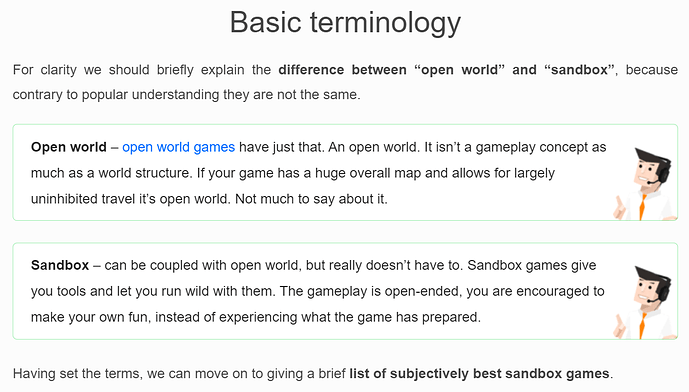
I’ll check it out. I am not a gamer, so I have never heard of this, but it sounds very similar. I tried to find it online (pardon my non-gamer ignorance), but all I could find were references to “open world” or “sandbox” games, but everything I read suggests that each game has created their own open world rather than accessing a centralized world. Is there a website link or something that you can send so that I can learn more about it? Is it a centralized resource that all “open world” or “sandbox” games access? Is it accessed via an API?

This is the definition that I found, but it doesn’t appear to be referencing a centralized “PASS” (Planet As A Service), as I like to call it:

I think that separating the Virtual World into its own entity/resource, and opening it up to many other platforms, would organically drive the development of surface level detail, both for static scenery, as well as for the full spectrum of dynamic elements. With other games/gamers demanding high levels of detail for cities, waterways, etc., the market will naturally “fill in the blanks”. Much of this may come at additional cost initially, but in the long run, it will just become the platform upon many sims/games are created.

They thought about it long before you did. What do you think artificial intelligence will be used for? To make us dream while they take our money … lol

1 Like

Isn’t this what google maps and bing maps do already?

While Bing Maps + Weather Engine (which gets you real-world maps plus a WX overlay) as IaaS is certainly one business model, it would have to evidence scalability, adequacy (to the customer’s application/game) and have an enforceable SLA. I’d be torn if I had to write the SOC-2 report for that service. It could be fun, or it could be a nightmare. :rofl:

They’re not there yet. As the old Microsoft of NT days reminds me (as a commercial beta test site), we all have to eat our own dog food. They’ve got to live out their milestones while creating new tools to facilitate all the goodness and potential that could happen based upon this emerging Cloud-based platform.

As for some of the other aspects - it should be noted that fidelity and focus matter. Notably, things look good and are oriented for flight (naturally). A service-oriented environment engine would need to be retuned for specific applications. What looks good even as close as 250’ AGL won’t pass muster for a ground-based simulation, where the fidelity is viewed at closer distances, and for longer periods of time. All those coastal roads that are sideways, the DEM that looks okay at VFR range for a couple of seconds as you pass over it? Won’t pass muster for a train or active ground sports sim. That implies making a scalable, relatively easy to reconfigure platform for starters. Ain’t there yet.

Give it time, sure. But let’s get back to the important business at hand - enough Sim Updates to fix major flaws in WX, avionics, aircraft modeling, ATC. To me, those are the big problems in very generalized buckets. Lotsa work there.

Bringing the entire earth down to street level with sufficient detail will most likely not be done by Microsoft. They simply lack the detailed map data, especially on street level, as compared to Google or Apple.
The most promising candidate is Google. They have really high res arial photography (as opposed to cough, cough, blurry Bing maps) and have street view. If I had to place a bet, I would say Google will at some point do what MS did here, but they will also have detailed and really pretty street level areas where you can drive through like you fly around on MFS right now. They will at some point, when the tech allows it, touch up their photogrammetry with modelling/textures that they derive from street view and…boom…there is your 3D city model that you can walk through. For example take New York: Photogrammetry is all there, but close up very rough because it is photogrammetry. How to turn this into a well modelled and textured 3D model? Zoom in in Street View, let AI find walls and geometry (with help of photogrammetry), extract images as textures and there it is. Long live the mighty AI!!!

This is already done and getting done more. You ain’t getting any royalty from anywhere anytime soon:

And though Blackshark found its start in the gaming field — and while it is working on this with Microsoft and Asobo Studios — it’s actually not focused on gaming but instead on things like autonomous driving and geographical analysis.

tbh, Blacksharks Ai solution will always result in very artificial looking street level modeling. Just no way to AI-generate the details. This is where Google has the edge because they have been collecting so much street level info with their Street View, it basically screams out loud to be joined with their photogrammetry data.

Not even close, most of google are 3rd party provider license which all can access, 80% of area are not even on photogrammetry, tons of photo sat are not in high resolution, photo mixed taken from different season, time of the day, with artifact, glitch, tiles, clouds on photo sat, unmatched colour terrain and so on.

So they begin at the sky for the sky is the …
The only limit is your own imagination, i mean
I like the tune of this tread and thought that i would happend some years ago
I hope the water depth of the sim and create som underwater scenery as well
So that its possible to get a boat and sail there to dive into the underwaterworld or drive on the highway to the port or the airfield.
This virtual earth would populatie itself and you can see it all around the sim and no ai traffic won’t be needed anymore

I agree that Google’s imagery and data are likely superior, and the idea of using street-level imagery to generate/supplement the photogrammetry is precisely what I was referring to in regards to people streaming their cell phone images with location data and/or point clouds to an AI server that will process/stitch it all together. Areas where there is lots of participation by the users will result in higher resolution/quality/up-to-date imagery. There are so many cameras everywhere now, that if you were to harvest imagery from just a small percentage of them (simming and gaming community), then you would be able to do a pretty good job up updating most areas of interest. And yes, there will always be parts of the planet that are inaccessible for one reason or another, so let’s get that conversation out of the way. We are talking something like 5-15 years for this to mature, in part, just waiting for the technology to trickle down to the level where it is not a prohibiting factor for the majority of interested parties.

The “world” that FSX used could also be licensed commercially for other use cases, where an accurate world model was required (accurate for that era). I don’t remember the product name, but it was essentially possible to license the simulated world as it was available in FSX and use it in your own projects.

1 Like

Think that was ESP right?

1 Like

Well remembered