Again, I’m not referring to charts data, but rather looking for specific ways the navdata is incomplete by default and “fixed” by Navigraph. You and another user have provided two specific examples, and I’m grateful for that ![]()
1 Like
I know that. Nav data that we get for free in MSFS 2024 is augmented by data from the FAA although it isn’t perfect. The FAA offers this free of charge. This only is good for the US.
2 Likes
Right - so if those developers would make the choice to use the default data, as many other developers (even those of “high-fidelity” aircraft) do, we wouldn’t have to pay extra money and on our end would notice no difference. That’s pretty simple, right?
Yep, I’m certainly not arguing the benefits to accessing the more-complete Jeppesen charts via Navigraph. For those flying to the many airports not covered by LIDO and the FAA there is no alternative and Navigraph offers a great service for those simmers. There’s a reason I pay for it myself ![]()
1 Like
It goes beyond just charts. Personally these days I only go with a Navigraph (Jeppesen) navdata sub and stick to the charts the FAA provides. I only fly in the US.
And I’m looking for examples of how specifically that is true. You’ve provided 7ME as an example, but I’m looking for more.
It’s been a while since I’ve looked but if I recall approaches at KWHP show up differently depending on the navdata provider you’re using.
1 Like
Perhaps over time, examples will trickle out. I remember during 2020 there were occasional reports of nav data errors that would be fixed with Navigraph. I reported a few. Sometimes they were things like incorrectly placed ILS locations causing you to land on a taxiway instead of a runway ![]()
I think, if the LIDO provided navdata in 2024 is, let’s say, 95% accurate and Navigraph is 99% accurate, I personally will chose free 95% over subscription 99%.
How complete is the navigraph data for Asia, middle east and especially Africa? This is an issue because in Africa there are many bush strips that sometimes even the EFB Has no knowledge of. Never mind Navigraph.
Yeah, and part of the issue is that Navigraph navdata overwrites/corrects more than just what’s included in the default navdata. Airport identifiers, like what @Maki152 has pointed out or naming conventions for tower/center/control as @Zeke12587 found are actually outside of that so would need to be corrected in places other than the core navdata. ILS frequencies/alignment is another example as those are most frequently handled by the scenery, not the navdata.
So many of the benefits to using Navigraph navdata as shown so far are very real, but are not actually related to deficiencies within the sim’s navdata technically.
If you fly online like I do (VATSIM and PilotEdge) Navigraph (Jeppesen) navdata is pretty invaluable.
1 Like
Again, I’m looking for specific examples, not talking points - I get that everyone who uses it says/thinks that it is, I’m trying to find quantifiable ways in which it is superior. Thanks!
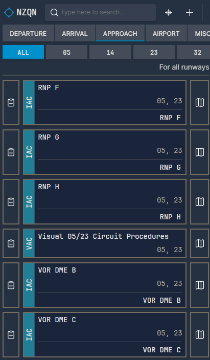
The spectacular NZQN Queenstown RNP AR approaches are only available with Navigraph data and are missing by default, or at least that was the case a year or two ago when I first subscribed to thier services.
2 Likes
Great example! And it looks like the default navdata is also still missing this, at least based on what’s available via planner.flightsimulator.com
Can I nominate you to ask on the WT Discord flight planner channel and see if they check if the default data is missing/wrong? ![]()
1 Like
So per Working Title those approaches are operator-specific and are manually added to the AIRAC data by Navigraph. There’s an addon on flightsim.to which can do this without Navigraph navdata, however that obviously doesn’t magically create LIDO charts for it since they don’t exist. So TL;DR if you want those approaches in your avionics without Navigraph, it’s do-able - if you want the charts, it’s not.
Good work ![]()
This does clearly highlight a Navigraph advantage. They own their own dataset, so they can make manual changes not possible for licensed data. This also allows Navigraph to make changes and release updates at a moment’s notice, where a user can just click the “update” button and get a new addition or fix nearly instantly.
It is nice to have the kind community folks release fixes for this particular issue on fs.to as well for those that don’t have Navigraph navdata.
2 Likes
VQPR - Paro, AT98 - Wolfs Fang Runway, historical airports like Berlin Tegel EDDT, … and so on, and so on - only a few of many differences …
But in general, both worlds are good and competition is good, fair and not bad.
Cheers
Richard
7 Likes
Thanks, Richard! I agree competition is good - I do wish more developers would take iniBuilds’ approach in offering users a choice to use default or Navigraph navdata, as there’s clearly an advantage to your product, but it’s also not for everyone. Maybe Someday ![]()
1 Like
Working Title is also able to make these kinds of changes to the data set, as evidenced by the many airports (many closed, some even fictional) that appear in the default navdata to support Career mode. I believe that specific example at NZQN just hasn’t been added as it’s operator-specific and they wouldn’t be able to provide the charts to support it, I imagine.