All - Sort of confused. I was under the impression that Navigraph is a pay service? If that is wrong, then did they change their policies in the last years? I did have their application on my PC, but once they wanted money, I backed away, because what I wanted was approach plates, and those I can get free, from lots of places. I for sure DO NOT TOTALLY understand what Navigraph can offer me and so please help me to understand the advantage of having their service/stuff. Reason, I ask is I got a request to partake in a survey they conduct annually. I am not sure I can fully be comprehensive to the survey since I don’t use their service. Not asking for you to influence my answers, just want to make sure I am not missing something, or under some false narrative. Thank you in advance.
Navigraph offers you a comprehensive app/programm that offers easy access to airport charts and navigational information around the globe. It also offers up to date AIRAC databases for a lot of third party planes - and also presumably MSFS 2020 stock planes.
All of this is essential if you want a realistic flight planning and IFR experience. They have great coverage and their charts, while not legally allowed as real navigational aid, are very close to the real world charts. You get all sorts of information about your departure and arrival airports.
Arrival and depature procedures, preferred runways for different times of day or wind conditions. Everything you need to know basically.
Since this information changes constantly, up to date charts and nav data is really important, just like in the real world. You really get a lot for the subscription.
Yes, Navigraph has a subscription.
You can use the Navigraph datas to overwrite the datas in MSFS. There the data are NOT COMPLETE!
Many procedures are missing.
Navigraph provides the complete set of maps with all the procedures from Jeppesen, thus from real life.
Every month I overwrite the existing datas in my MSFS with the latest airac cicle and so am 100% sure to find the same datas and procedures like in the Navmaps from Navigraph I use.
You are not required to be a navigraph customer to participate in the survey. And please do participate in the survey cause it’s very important to third party developers.
I find it nice to have as I can easily find charts for airports I am flying to. It is easy to find them on other websites like flightaware which is what I used to do but the convenience was worth it to me. However I don’t think I would use navigraph unless I had a tablet or laptop nearby to run it though.
Please all elaborate on how much and how it works please. I have account on there, but never went the final step and paid money for the services. And not sure how it integrates into MSFS either, so a little more information would be very helpful for many of us. Thank you.
The best part, in my opinion, is the live following of your plane. This includes when you are taxi-ing to the runway or to parking. You can see your plane live in an overlay in realtime. Way better than some free options, like STKP, which is very slow and laggy. The live overlays during your flight, stars/approaches, airports, is super helpful, especially if you use live atc like vatsim and need to actually follow directions.
I think that is mostly accurate, especially the last part: “from lots of places”. For approach charts, the advantages I see with Navigraph charts are:
- You have a single place where all your charts are available. No more searching for them in a multitude of different locations.
- Coverage. There are lots of places in the world where it can be very challenging to find charts. Navigraph has them. Whether your next stop if LA, Paris, or Noumea in New Caledonia, Navigraph have the charts.
- Quality. Jeppesen’s charts are bettered by none and far better than most. If you are in the US you are lucky, since FAA’s charts are also really good, but in most parts of the world I find Jeppesen’s charts vastly superior to what the local aviation authorities publish.
- Presentation. The Navigraph charts app has some Electronic Flight Bag (EFB) like features that I find very convenient. Having the maps organized to match your flight plan and bringing them up with a couple clicks is super convenient when running the app on a laptop on the side while flying. And it supports things like chart overlays and showing your location on the approach chart if you want to use that.
You might find this presentation helpful:

Utilizing Navigraph’s “downloader” every month, you can update the nav data within MSFS. However, that update won’t correct the inherent problems within MSFS’s internal navigational database, nor MSFS’s propensity to randomly change your flight plans when you import them into the sim. Which is why I very seldom use MSFS right now. It is too much of a PITA to plan out a flight, and then spend an untold amount of time to correct the changes that MSFS makes to my flight plans. Regardless, one of my favorite features of my Navigraph subscription is the visual representation you can have when planning departures and arrivals. My second favorite feature is the moving map that is on my iPad, or Android tablet.
I happen to be a Navigraph subscriber and took the survey yesterday.
I can ensure you everyone who is to some degree interested can answer the questions of the survey as it not about Navigraph but FlightSimming in general.
Oh, I can even import them into MSFS? Finally time to subscribe the first time!
I’ve subscribed to FMS since FSX. Just gone for the charts subscription. It’s maybe over the top as I also have simplates but the app and the web map is amazing. Overlaying plates on the flight route moving map is incredible. As it’s also web enabled it means I can run the flight plan on my iPad.
Oh and taxi-ing is easy with the sim connect and your location at the ramp.
As an avid Vatsimmer I’ve always used their FMS data updates on advanced addons, they’re invaluable and there are several options for what and when you pay/update. I don’t use/need the charts.
Ref the survey, please do complete it! Yet again it’s badly designed (always is!) But does provide useful info for the industry.
That’s exactly what it does do - it corrects the issues inherent in MSFS’s internal navigation database by overwriting it with Navigraph (and thus up-to-date) AIRAC data.
Some of your other points are more accurate, but there are workarounds. For a start, Navigraph will also load AIRAC data for LittleNavMap which now has a MSFS .pln export that I have never had an issue with (in terms of MSFS changing it on import, and given that MSFS has the updated data from Navigraph Beta).
Granted, MSFS will retool a flight-plan if you change anything on the World Map page but that’s not a “database issue”, it’s a coding and logic issue. (Although if you want to change your starting location from the Runway it defaults to on load to a parking space to start Cold and Dark, do it from the dropdown box and it won’t retool the flight plan - doing it from the World Map itself will.)
But if you load a .pln from LittleNavMap and then change your flight plan in the sim, using the Garmin interface in your plane, it works perfectly well. (Other issues exists - doubling back when changing approaches, etc., but for these too there are workarounds. And again, these aren’t database issues, these are code issues - bugs.)
So I guess what I’m trying to say is, I understand you’re a little frustrated with the Sim, but that’s not Navigraph’s fault, and, in fact, Navigraph Beta does fix one of the major issues with MSFS - an out-of-date and incomplete Navigational Database - so jumping into a thread about what Navigraph has to offer with a statement that it doesn’t fix the exact thing that it does fix is a little misleading.
Yes 100% my experience plus they really listen to their customers when you post questions or bugs in their forum.
Just to build on what you said, it also updates the Navdata in SimBrief for those who use this tool for route finding and flight briefing. Advantage is that one can eg file a Vatsim flight plan and be sure the AIRAC data is consistent and the flight plan valid in Vatsim
I’m curious, haven’t looked into it by myself yet - do I get the AIRAC data from navigraph in a somewhat documented format, so I could use it myself and code my own tools using it?
Actually, my comment was 100% correct! Look at the SID, STAR, and APPROACH procedures as published by Navigraph (and as provided by Jeppesen). MSFS is still missing certain Waypoints, as it has since the beginning of Tech Alpha. Don’t get me wrong, I LOVE Navigraph, and gladly pay for my subscription. But to say it corrects MSFS’s shortcomings is an outright lie. Yes it provides the data, but MSFS chunks it out the window. In total honesty, this is not a Navigraph issue. This is 100% an MSFS problem. As a longtime user of Navigraph, as well as a Beta tester for Navigraph’s integration into MSFS, I do report bugs and suggestions to Navigraph. I also ride the MSFS Zendesk light a old mule for all of its nav data bugs. Including the fact that MSFS does change your flight plan regardless of how you change for a cold and dark start. Oh, and let me give you a prime example of how Navigraph doesn’t fix all issues. The STAR, GNDLF2 into Atlanta has multiple transitions. However, MSFS only shows one - SMAWG. In my flight plan from KJAN to KATL, the first transition available is ORRKK, but MSFS omits it and the following 3 waypoints of the STAR (MORDR, RAETH, NZGUL). Although Navigraph has provided that data to MSFS, tell me, just how is that fixing the nav data bug in MSFS? Nevertheless, I know this is not an issue with Navigraph. It IS a problem within MSFS. I’d share other examples but I have neither the time or the energy.
You’re trusting the World Map page too much:
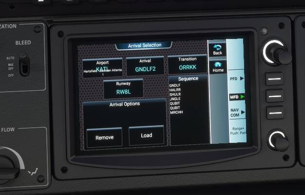

(So, loaded in clean, set KJAN as Departure and KATL as arrival, and the GNDLF2 transition. Then in plane I selected the Arrival again, and the correct ORRKK transition and it filled everything in. What I’ve not yet done so you don’t accuse me of cheating, is delete the OnRoute Waypoint for SMAWG but if I were flying this I’d do just that as I wouldn’t trust MSFS not to double-back on itself (as I mentioned above) if I didn’t).
So, all the data is there, and the World Map page is programmed badly, but the G3000 in the TBM can access all Navigraph data, as provided.
(Addendum:
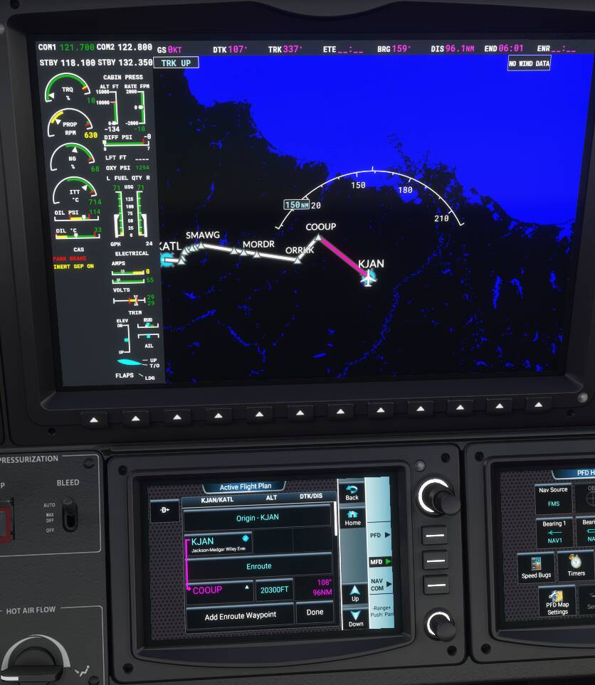
World Map actually added loads of waypoints I’d delete, but I didn’t set a SID, so maybe had I loaded in a .pln, it wouldn’t have. That said, point stands - the transitions you were missing are actually there, in plane.)
For me, I would not be able to use this sim without Navigraph. Obviously having every chart at my fingertips and updated Airac is awesome, but the moving maps feature is incredibly helpful. It’s no secret that the ATC in MSFS is atrocious. Having moving maps allows me to see the path of my aircraft right on the charts, what my speed and altitude should be, hazards etc. Really helpful during taxiing.
I recently mounted a tablet on my flight sim table. Prior to flight, on the PC, I set up up my flight through Simbrief, open the flight in Navigraph and choose my departure and arrival, pin my charts, then export to MSFS. I close both Simbrief and Navigraph on my PC, then open the Navigraph app on the tablet. Now I have all my charts available and can follow the flight path right on my tablet while keeping the sim displayed on my PC.