Hi all.
I am starting to try the Bush Trips, and also some addons, as VFR Academy, use them as template for the missions.
Also with two monitors, I find quite cumbersome the way Navlogs are presented in MSFS, so I would prefer to be able to print them, and maybe add some notes for the various steps of the routes.
At present I did not find any print/export feature, do you know if there is such a possibility?
Thanks.
2 Likes
I would like these kind of features too, i don’t think it would be very hard to implement them.
- Import/Export and print flight plan to and from various file formats.
- Export and print navlog, logbook, etc.
3 Likes
Hi.
Concerning flight plans, I use Plan-G and Little Navmap, and so the import-export is not a problem.
But I am a bit surprised that the Navlog did not receive much attention, also considering the number of Bush Trips and third-party products based on the feature. Are we the only ones that find quite inconvenient the use of the present Navlog, also on a second monitor?
Thanks
I don’t know, it’s also strange you cant zoom in or out and change the text size of the nav log, with Ctrl-Scroll for instance. If i move the navlog to another screen with another resolution the text is very small. Would be nice if you could resize the text per window.
But it would also be nice to see import/export functions of all sim data. And maybe other file format support for flight plans (Sky Demon, Garmin, etc). These functions can be implemented very easy.
3 Likes
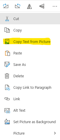
It’s easier that you might think. Microsoft OneNote can do this for you with ease.
Take a screengrab, paste it in to OneNote, and then tell OneNote to extract the text. For long NAV logs you would need to do this multiple times. For example:
Upload this to OneNote, right-click then click “Copy Text from Picture”:
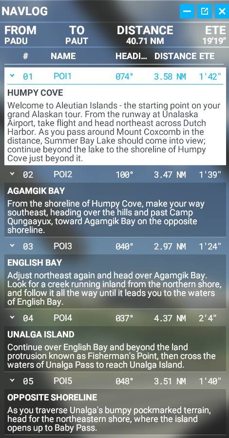
NAVLOG
FROM
PADU
TO
PAUT
NAME
POII
DISTANCE
40.71 NM
ETE
19’19"
HEADI.„ DISTANCE ETE
0740
3.58 W 1 '42"
HUMPY COVE
Welcome to Aleutian Islands - the starting point on your
grand Alaskan tour. From the runway at Unalaska
Airport, take flight and head northeast across Dutch
Harbor. As you pass around Mount Coxcomb in the
distance, Summer Bay Lake should come into view;
continue beyond the lake to the shoreline of Humpy
Cove just beyond it.
P012
v 02
AGAMGIKBAY
1000
3.47 W 1 '39"
From the shoreline of Humpy Cove, make your way
southeast, heading over the hills and past Camp
Qungaayux, toward Agamgik Bay on the opposite
shoreline.
P013
v 03
ENGLISH BAY
2.97 W 1 '24"
Adjust northeast again and head over Agamgik Bay.
Look for a creek running inland from the northern shore,
and follow it all the way until it leads you to the waters
of English Bay.
P014
v 04
UNALGA ISLAND
0370
4.37 W 214"
Continue over English Bay and beyond the land
protrusion known as Fisherman’s Point, then cross the
waters of Unalga Pass to reach Unalga Island.
P015
v 05
OPPOSITE SHORELINE
3.51 W 1 '40"
As you traverse Unalga’s bumpy pockmarked terrain,
head for the northeastern shore, where the island
opens up to Baby Pass.
It requires some minimal formatting but it works.
Hi, thanks for the suggestion.
Actually, I often use Onenote for other tasks, and I know its capability to extract text from images.
Anyway, in this case, as you correctly noticed, there are two annoyances. First, for a long trip, you have to take several screenshots, and then you also must reformat the result.
So, while doable, it is not so straightforward. I still hope that MS/Asobo or modders will add in the (near) future some basic features to the present Navlog.
Thanks.
2 Likes
The lack of a print facility for bush trips navlogs is frustrating and I’ve also hit the ‘disappearing navlog issue’ part way through several bush trips. I’m working on a tool to extract the text from the mission ‘loc’ file. It’s messy but I think I have a working english extract for the france bush trip. Hopefully I’ll be able to add the headings and distances at some point soon.
PM with your email address if you’d like the france trip output. I can repeat the france extract for other languages easily enough if anyone needs it but can’t post the output on this forum as the forum limits attachment types.
1 Like
I totally agree. I would love to have the full NavLog to plan each trip with, do a map study or googlearth study of all the POI’s they point out for each leg. The included map is useless for finding the landmarks. I’ve been running littlenav map during most of the legs and it helps a ton. Part of good flying is proper planning and trying the learn the NavLog on the fly is really difficult. It makes no sense why the NavLog can’t be printed or exported.
Possibly shutting the stable door after the horse has bolted for quite a few people but I’ve now produced text navlog extracts for the official bush trips. Hopefully they’ll be useful for anyone yet to fly (or refly) any of the trips.
5 Likes
No, no, the horse is still inside.
Thank you for the effort, really appreciated.
Very much appreciated, thanks a lot!
This topic was automatically closed 30 days after the last reply. New replies are no longer allowed.