My experience with Navblue (which only includes their chart service and within European airspace) is really good. I don’t believe NavBlue has the LOC course in Innsbruck for example wrong in their nav database… If so this would be really shameful and potentially dangerous for real world airlines relying on their navdata.
Our FMS navdatabase is from Honeywell and we have identified numerous errors in real world navdata. Maybe NavBlue is okay in EU airspace but ■■■■ in the US and vice versa with for example Honeywell .
Yes, possible - I can’t judge that but we have other six continents where simmer wants to fly and there must be any reason, why Asobo has begun to merge different data sources. But back to this topic - you need more or less complete and accurate data to fix all these different types of approach courses. Charts alone are not enough …
Yes, exactly, I´m pretty sure that the NavBlue loc-courses are correct too … personally I guess, there is an internal parsing issue to transfer the ARINC424 data into the correct values for the sim.
Can´t follow the argument - why do you mean, that with auto-tuning the course is correct? Will this be really validated in the FMC? When I set a wrong course in the data, do the auto-tune overwrite the course than?
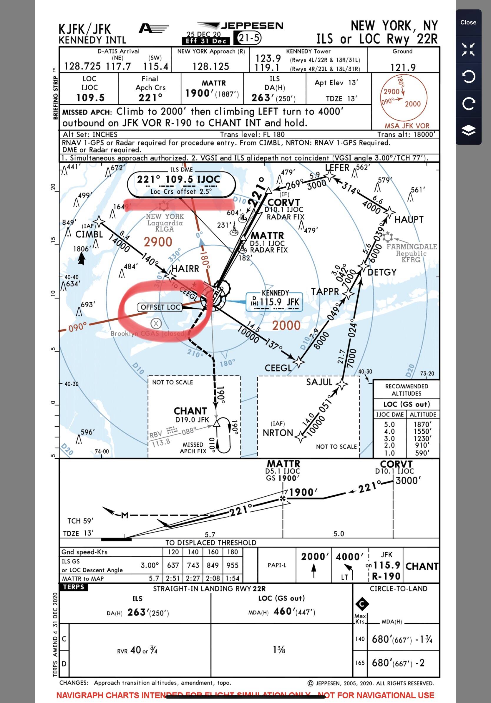
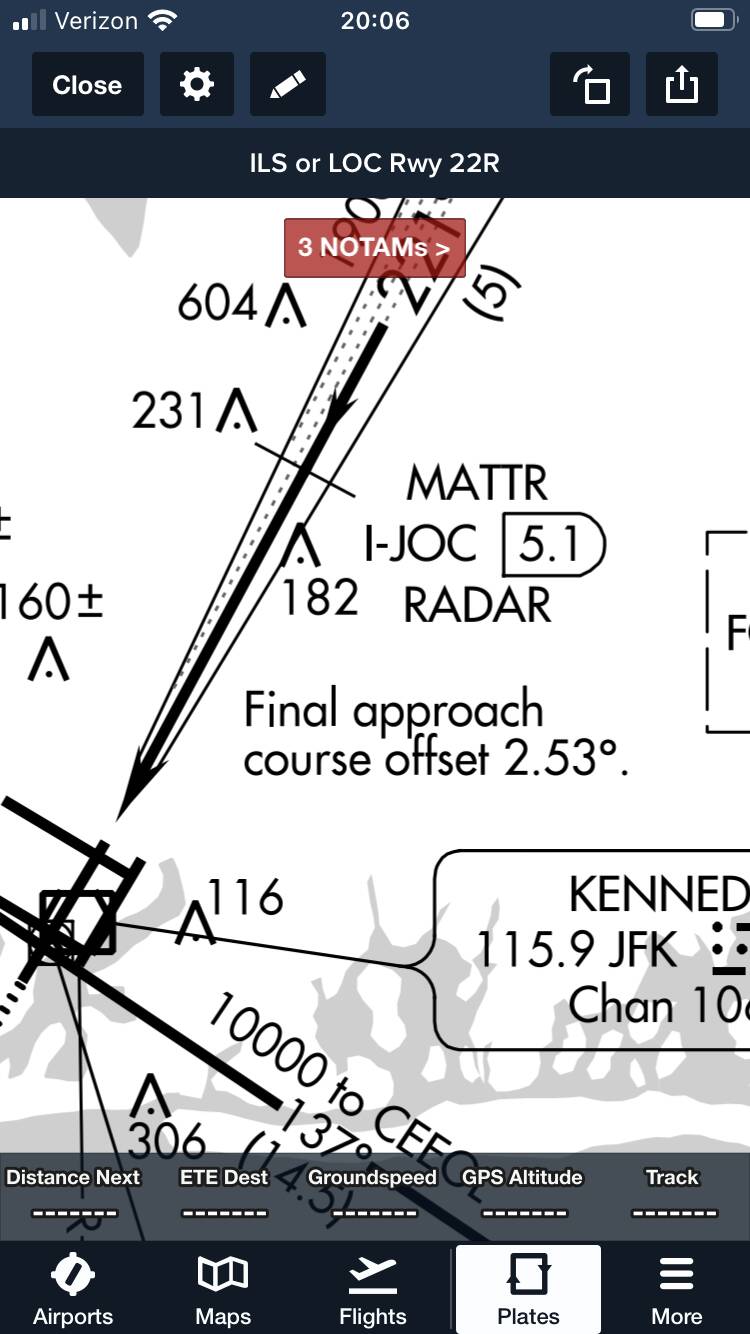
Not a bug. The real KJFJ ILS22R is offset to the right 2.53 degrees. This is exactly correct. When flying the approach, the aircraft is not aligned with the runway centerline until arriving at 250 feet AGL
This is actually correct. The runway heading is 224°, compared to the approach track of 221°. There is also a small note on the approx chart below, as shown below.
Hmm, I need to check that again. It seems it’s way off to the right - correction : LEFT (mental slip) from very far out. I need to check the charts again, Thanx! Would you mind flying it and checking it’s correct?
Literally exactly the same as any other ILS approach. As mentioned above, the offset is designed to place you on the extended centreline 250-300ft above the runway. You will be to the right of centreline during the approach, the further away from the runway, the further right you will be. Start your lineup correction slightly before reaching the centreline so as not to overshoot. This is done visually, just look out the window and line up with the centreline.
A 2.5° offset is quite minimal. For example, a 10 Kts crosswind would actually have an aircraft crabbed into the wind more than this. Obviously you’ll still be on the centreline in this case, so the correction is slightly different, but it highlights the point.
The important part is don’t reference the LOC below 250-300ft, as continuing to follow it will put you left of the runway, hence auto land is prohibited.
I have flown it before. The approach brings aircraft in at an angle from the right. The localizer crosses the extended centerline at the point where the localizer meets the glideslope MDA. This particular ILS is offset because aligning the localizer directly with the centerline would have required putting the localizer in a saltwater marsh at the far end of the runway (04L) which is a protected wetland.
Therefore, the localizer antenna is located to the left of runway 22R, just beyond the intersection of runway 31L/13R
There is a note about the offset on the approach chart.
Thank you so much @HalberQuacky and @Norman999933 for taking time to explain to me, I really appreciate it!
I will have to try a new approach and see how it does. I just remember it as if the whole thing was offset way to the left, even from far behind. I was thinking I had the course set wrong but the course is set by the flight management computer in the airbus and is automated. I need to double check that and also fly it with the Piper to get rid of any automation mishaps Again, thank you so much!
Originally i thought it was one of those Airbus “Oh it’s doing that again”, or “Why is it doing that” Fly by wire - moments
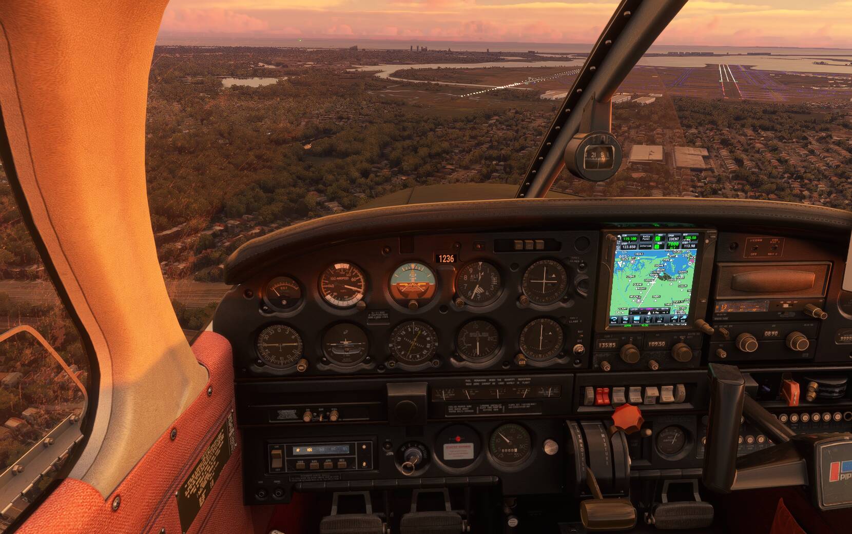
Nope, this still doesn’t look right to me. Here I’m at 600ft, right on the ILS course 22R 109,5 (excuse the crabbing) - but as you can see I’m very far off to the left. The second picture I’m at 300 ft above the runway extended centerline, and look at the ILS, it wants me waay off to the left.
Ah! Yes, this is a problem with the default nav data. The default data has the wrong ILS course assigned to the ILS 22R transmitter. The transmitter is located in the correct physical location in the scenery, but the localizer heading is incorrectly set to the runway heading of 223 degrees instead of the actual r/w localizer heading of 221 degrees.
In order to solve this, it is necessary to use the Navigraph core nav data replacement for the MSFS default nav data, Navigraph sets all localizers to the correct published heading, while the default nav data sets all localizers (with few exceptions) to the exact runway heading. This is fine in most cases, but if the localizer is actually offset, it will guide to to a landing alongside the runway.
When the ILS22R is used with Navigraph core data, the aircraft approaches the runway at an angle from the right side, and comes even with the runway centerline at the MDA altitude of about 250 feet AGL.
If you are already a Navigraph subscriber, there is no additional charge for the replacement data for MSFS, however if you do not subscribe to other Navigraph services, the MSFS replacement data would not be free.
If you use Little Nav Map, with the original MSFS data, you can inspect every airport you intend to land on. If you zoom in, you can already see if the ILS is gonna crash you and if you should bring a cat with you in the cockpit. Some airports are really dangerously off.
But seeing the troubles of Asobo and how almost everything is broken, except the pretty pictures, I have no idea when this stuff will be fixed.