Today, Orbx have released their new Himalaya and Central Asia Mesh for Microsoft Flight Simulator, and in this video I take a first look at what it looks like, and offer my opinion with an approach into Paro!
I hope you all very much enjoy it!

Today, Orbx have released their new Himalaya and Central Asia Mesh for Microsoft Flight Simulator, and in this video I take a first look at what it looks like, and offer my opinion with an approach into Paro!
I hope you all very much enjoy it!
Great video. I guess the first and main question most will have is “how does it compare to the default mesh? Does it make a big difference?”
I assume that such a vast and remote (for most of us) territory isn’t the usual mesh update of e.g. the suburbs of Oslo or Munich, where people will be quick to spot any differences and improvements. So in my opinion this new addon would be something to consider buying only if it makes a significant impact.
Based on their previous mesh , without a side by side it is really difficult to see a difference. Have a look at Youtube there is a good one on ORBX NZ MESH by SimHanger Flight Simulation, and I think it gives it a fair chance but the question remains, why do these products exist if they do little to nothing to improve things not to mention the free mesh stuff on Flightsim.to
Some more info can be found here: ORBX - AS Himalaya and Central Asia Mesh
Shows how much they’ve updated. Would be nice if they would also share a comparison video.
Thank goodness people do in-depth reviews because a few screenshots and promo videos do little to really show anything to us.
In any case, a 20GB mesh update for 8 euros or so, sounds reasonable. I guess it’s only a matter of time until we see if it’s worth it.
I bought the 10M DEM mesh thats available from the sim market a while back. Not sure if this Orbx one is any better or not. Seems like it might cover a wider area though.
The one that I’ve got does look noticeably better than the default mesh but suffers because these higher resolution DEM’s really have to paired with higher resolution satellite imagery to look truly spectacular. As the Swiss Alps in the sim proves. If you stretch low res photo textures over high resolution DEM’s it never looks great.
Ah I was just about to link their forum comparison images but I see you beat me to it ![]()
This one is rather vast and pretty much covers a lot of China all the way through the Himalayas and into Northern India/Pakistan amongst others ![]()
Check this out for a map showing the coverage which displays it quite nicely https://forum.orbxdirect.com/topic/210984-announcing-himalaya-mesh-for-microsoft-flight-simulator/?do=findComment&comment=1787039
I have bought orbx mesh and flown the far West of nepal that I know in real life and I am very happy of it. The added resolution solves the most blatant issues like rivers climbing deep gorges and the airport surroundings are more realistic. there remains some parallax issues around high summits and ridges with imagery which I think was “corrected” with imprecise DEM data and this remains very visible because the bright/shadow line of the ridge in imagery appears below the dem ridge line. But I am very happy overall and it makes Nepal a great destination in the sim along with the freeware airports at flightsim.to !
I have a favour to ask for those who own the Orbx Himalayas.
The littmus test for an improved DEM in the region is my RL-favourite - Laila Peak in Pakistan:
Laila Peak (Hushe Valley) - Wikipedia
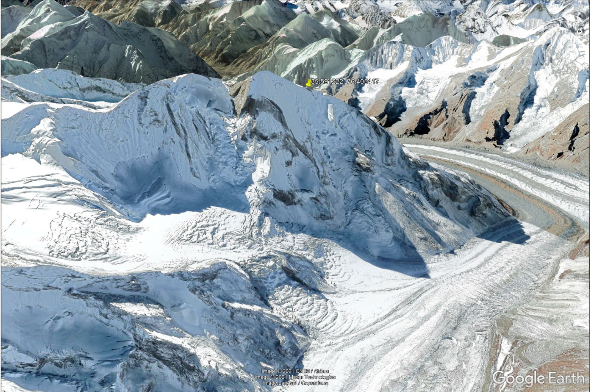
35.591221, 76.405418
Can someone please snap a ORBX pic from a position just NE of it and we compare it to:
Reality:
Vanilla MSFS, terrible:
Google Earth, well, well:
then we can judge if its worth it.
thx in advance
That’s a nice challenge, I’ll try to take a picture (or video) later in the evening if no one else manages to do it first.
Yes this would prove if this OrbX package has true quality! I am looking forward to your screenshots.
It’s a bit confusing though. Wikipedia gives the coordinates as 35.591222, 76.405417, however that’s 120km southwest of the Laila Peak shown in Google Maps (at 35.956757, 74.960961)
Anyway, judging by other data from Bing Maps and Little Navmap’s OpenTopoMap I think Wikipedia is correct and this must be what you’re looking for:
The north-northwest face of the peak as seen from the bottom of the glacier. I’d say it looks slightly better than the above images but still nowhere near reality. Not sure where Orbx are drawing their data from.
thanks Zeppos,
slight impovement indeed. Did you use “live weather” so that the glacier is snow covered as Orbx doesn’t change the Bing map, correct?
Yes its confusing, there are a couple of Laila or Layla Peaks around but my Wiki-one is it.
Orbx claims “three different sources” , 10m res - which is way off for a decent cragginess.
Asobos Himalaya mesh has improved over time without telling us (especially in popular regions like Everest), there is likely more to come.
I’m undecided on buying, not because of price but those ever longer loading times.
BTW: I always test sim-DEMS besides Laila with Matterhorn, Dolomites and Fitzroy/Cerro Torre.
So far in MSFS only the Horn did pass…
Yes, that was with live weather. Initially I had live weather disabled as I didn’t want clouds, haze etc but snow would then disappear and the peak looked like ■■■■ ![]()
Also I don’t think the addon affected my loading times at all. Both the Laila Peak and the area around Everest load as quick as everything else in MSFS.
The Laila Peak is disappointing and nowhere near reality, but the whole area has gorgeous scenary.
Looking forward to more HD meshes for scenic areas.
Will this be available in the in game shop at some point?
Am I the only one that cant use Lukla anymore because there is a huge mountain right at the end of the runway?
if I uninstall H&CAM its back to normal
Dont know if its related to SU9 or something