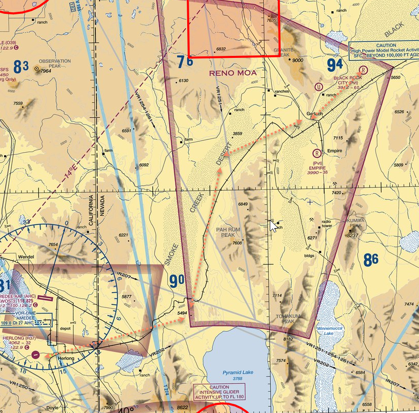
SkyVector.com is excellent. When I did the CA/NV bush trip, I used screen caps from SkyVector and marked my routes using SnagIt screen grab / editing software to keep in the spirit of navigating without a GPS (or tracking software add-ons). GreenShot is an excellent freeware alternative to SnagIt, BTW. Poor color choice on my part for my route (orange dotted lines) below- I should have picked something more contrasting.
3 Likes
I draw my flight plan on there too, hitting the navaids or intersections I want. Then I can use Windows Snipping Tool (built into Windows) to grab it. I still write down my navaids and freqs etc in a notebook so theyre easier to find. 
1 Like
You can download and use GLOBE data in place of sim scenery. Guide to do this is in the manual here 55. Options — Little Navmap User Manual
Section 40.14.2
I have been running 2.4.5 with only small mismatch issues. Nothing major.
Saved navmap flightplans load in MSFS and you can load a MSFS flightplan in navmap as well with no issues
Pilot2atc has voice recognition so I actually talk to ATC. It also allows copilot to handle comms and frequency changes and has a larger set of responses and requests. Addl it can handle ATIS with weather based on the sim or other datasets (noaa etc)
Finally the STAR/SID is imo closer to reality as is vectoring.
1 Like
I thought installing the GLOBE elevation data was just for that: elevation data.
I imported the GLOBE data as per the docs and I still have a red Database empty. warning/error at the bottom of the app.
I think we’re still waiting on the dev to update LNM to read the scenery from MSFS2020.
Working fine for me.
Maybe you have old scenery data from FSX that is still working?
Nope. I dont even have FSX installed. Others have been using the current version as well.
Oh, that’s cool! So does that mean there are no human traffic controllers? It’s all done by AI and voice recognition?
I’ll PM you so as to not clog up this thread with my troubleshooting. ![]()
1 Like
The error I think you are referring to is the aircraft performance file. It won’t load cruise alt without one. You can create one or just manually adjust the flightplan cruise alt
Yup no human controller all via Text2speech ( which you can also use to talk to ATC if you have trouble getting voice recognition working (it’s all english and I’m sure its not dealing too well with some dialects cough scottish cough
2 Likes
Added a head tracking software section to the OP! 
Just added Your Control: a simple shared cockpit solution for MSFS2020.
1 Like
Worth noting that Flight Plan Go is not available in the UK from the MS Store. Don’t know why, but that’s a real downer for me.
For US sectionals I use AirNav with my iPad sitting next to me. It also includes VFR sectionals for Alaska and Hawaii as well. I like the fact you can zoom in and out as needed wi two finger. Just type in an area or airport and your set.

1 Like
What’s this got over SkyVector?
1 Like
Pre-flight:
-
Haven’t used it yet but would use PFPX on occasion with the airliners
-
FlightRadar 24 and FlightAware for airliner routes, flights and gate information if I’m trying to model an actual airliner flight.
-
ForeFlight on iPad. I use this in the real airplane and works great for the sim, just not working here yet due to SimConnect issues. FlightAware directly imports routes to ForeFlight which is nice.
-
Navigraph on occasion for charts, especially outside US.
If you want a rotating 3D map and a replacement for the missing autopílot in some planes, you can use FSTramp from http://fstramp.com. This add-on can also be used with only one display, understands the BGL files of MSFS and shows on its map only what is really in the simulator.
1 Like
ForeFlight on iPad. I use this in the real airplane and works great for the sim, just not working here yet due to SimConnect issues. FlightAware directly imports routes to ForeFlight which is nice.
ForeFlight works wonderful with MSFS2020!
I use XMapsyV3 for it (yes, it costs, but no performance issues since the update) and it is very simple and easy. I havent done a flight without it yet!
And you can demo it with 2-3 airports, but as it works quite simply there is almost nothing to demo, if you use it with Foreflight.
Naviator works well with msfs, It’s like foreflight or garmin pilot but is available for android with a 30 day free trial, has traffic display (vatsim and PilotEdge traffic),… http://forum.naviatorapp.com/viewtopic.php?id=809