Vertical descent with full spoiler is not a very common situation but I often heard that spoilers where dimensioned to avoid overpeeding VNE. That’s the case in Condor. With full spoiler you can’t overspeed VNE. I haven’t try it IRL (and will never try that without proper aircraft and aerobatic glider instructor) but that’s an interesting difference between Condor 2 and MSFS gliders such as this one. Do you have an opinion on the issue ?
I just add an extra 500 feet or so … and it really can be quite exhilarating if you aren’t quick enough on the controls ![]()
Even if it seems exhalting, I don’t do aerial stunt training
1 Like
You could always do a winch launch and then slew..that should give you the airspeed you need when you come out of slew mode.
I love this bird but I have one question. What is the waypoint altitude? Once a flight plan is loaded the value never changes for a given waypoint. If I take-off with an aircraft tow for instance from a 2000’ msl altitude heading for a first waypoint in the msfs flight plan I show an 8,500’ waypoint altitude of first waypoint 35-40 miles away regardless of my current altitude, heading (track), speed. It never changes unless I cross the waypoint and automatically sequence to the next of if I change FSSOAR manually to the next waypoint another 60 miles or so from the first. Once waypoint changes to #2, the waypoint altitude show * 11,200 feet (with an asterick and that value never changes when that waypoint is selected. In the LS4 the waypoint altitude prediction changes with heading, speed, altitude, wind, water, etc. I can pick a higher glide speed over the ‘Speed to Fly’ and estimate an arrival altitude at a nice pattern entry . I cannot figure out how to do that in the Discus. Is Waypoint Altitude is FSSoar working properly or my brain not working properly (likely). Thanx for any answers? Keep up the good work.
I beg your pardon for a misword in the last post about ‘Waypoint Altutude’. When a switch from waypoint #1 with the unchanging ‘Waypoint Altitude’ of 8,500’ and change to waypoint #2 in FSSOAR the ‘Waypoint Altitude’ reads 11.5 * in feet. The ‘Waypoint Altitude’ for any selected waypoint in FSSOAR never changes regardless of present position, altitude, heading, wind, or weight. What is the purpose of ‘Waypoint Altitude’? or is it not working as I would expect like is does in the LS4. Thank you. HeadwindH
the waypoint altitude (i.e. the elevation of the WP in feet/meters MSL) comes from the MSFS Flight Plan. This only works as expected for AIRPORT waypoints. MSFS makes a complete hash of the data that comes out of the flightplan for intermediate waypoints, inventing new altitudes according to what the autopilot thinks your altitude should be.
The AS33 and LS4 support ‘extensions’ to the MSFS flightplan that allow you to put in elevations that MSFS doesn’t mess with, i.e. instead of calling a WP
“WP1”
you can name it
“WP1+1234”
and the nav instruments in the AS33 and LS4 will ‘decode’ that to know the elevation of the waypoint is 1234 feet.
I recommend you use the B21 Task Planner to create soaring flightplans as it automatically formats the WP names to include the elevations.
B21
O.K. Thank you for the reply. So even if it did work correctly, as I understand it the displayed ‘WP Altitude’ in the B21 planes only give you the actual MSL altitude of an airport not the predicted altitude a arrival over the airport if flown directly to it, and usless numbers for waypoints between airports. It look like It does not currently give a predicted altitude over the waypoint based on current conditions, correct? The number never changes for a give waypoint. Are waypoint altitude preditions planned to be part of the payware version sometimes in the future. I am from the midwest U.S.A. and we don’t have ridge soaring here. I would gladly pay extra for the predictions like the LS4 gives. Headwind
Thanx for the heads up about B21 Task Planner. I just read it’s ‘Help’ file (nicely written) and I think I understand the whole thing better and will give a try to adding Soaring Task to an existing MSFS flight plan and adding some from scratch. Lots of hubbub to get a nice flat land thermal XC flight in MSFS but is it about as much of a challenge and fun I have had in any simulator when it is all working. (that plus surviving a low minimum XC flight in the DC-6. Never flew gliders or round engines IRL). Thank’s again everyone involved for all your combined efforts. I am almost four years since retiring from a 50 year flying career but still have to get my flying fix in every day. Headwind Hesket, Wichita, Kansas
2 Likes
Hi!
Do you know by any chance when these gliders will be available for xbox? ![]()
I have good news for you! The whole point of the Nav instruments in both the AS-33 and the LS4 is to calculate your predicted arrival height at each waypoint in the task, taking into account everything that is likely to affect that arrival height (like the ballast you’re carrying, the distance and direction to the waypoint, the prevailing wind, the speed you’ve said you will be flying at via the Maccready setting)
The Nav instruments in both planes read the flightplan, and can interpret the elevations added via the ‘custom name’ method, or otherwise will use the elevation in the flightplan anddisplay that elevation for the waypoint AS WELL AS displaying the predicted arrival height.
The Nav instrument in the LS4 always shows you your (predicted) arrival height in meters/feet MSL, i.e. above sea level, so it doesn’t really matter how much MSFS mangles the actual elevation of the waypoint. The Nav instrument will show you BOTH the elevation of the waypoint (which could be garbage) AND the predicted arrival height MSL, so you can do the math and ignore the WP elevation if you want.
The Nav instrument in the AS-33 can basically do all the same calculations, but in addition it has a ‘settings page’ where you can specify that arrival heights should be RELATIVE to the WP elevation. This is the perfect solution where you can fly 50km on a final glide, seeing the arrival height going +ve and -ve, all relative to the destination (i.e. heights AGL). Of course this relies on an accurate elevation for the waypoint, so to use the relative option you need to EITHER encode accurate WP elevations into the WP names (B21 Task Planner does this for you, but it’s easy to do manually - just add +elevation to the WP name) OR only pay attention to the relative arrival height for your destination AIRPORT, because MSFS doesn’t mess this one up.
See? It kicks redacted-by-MS, but I had to work around severe flightplan limitations in MSFS.
You can see the Nav instrument doing its thing in this demo AS-33 cross-country flight. The LS4 has a similar capability but a simpler Nav instrument to look at:
1 Like
Hi, I love gliding and I love your rendition of the discus 2.
That said - it seems to me the gliding performance is quite far off from what it should be. I first noticed that it seems unrealistically hard to fly forward between two thermals at speed - and the displayed sink rate is ridiculous.
Am I the only one observing this?
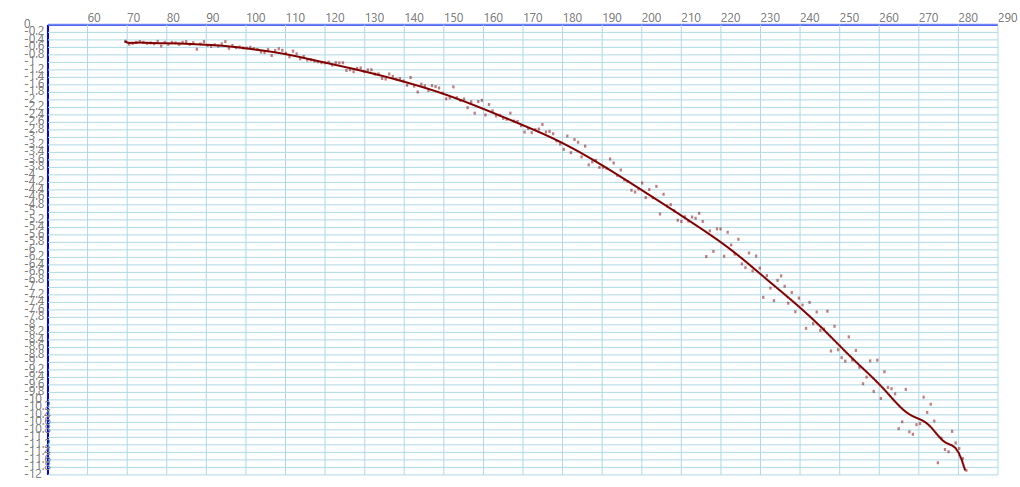
So I took it out in calm air and went through the (fun) exercise of recording a polar. The results in short:
- The simulated sink rate is about twice what it should be (120km/h and above).
- What the varios show is even further off - 3 or 4 times the expected sink rate. Additionally there is some odd behaviour above 200km/h. In fact, at least for the “netto” mode the behaviour is wrong through the whole range.
Anyway, here is what I recorded (calm air, ~4000ft, no ballast, 80kg Pilot):

- The grey curve is the polar of a Discus 2b roughly transferred from a chart from here. This (or slightly better) would be the expected performance of a 2c.
- The orange curve is data read out through simConnect (VELOCITY BODY Z and VELOCITY WORLD Y). This is probably TAS. The jitter is a result of my crude method.
- blue and yellow curves are read from the glider instruments. IAS and Vario (avg) in netto and TE mode.
My expectation would be for the orange and yellow curve to roughly match the grey curve. The blue curve (I think) should be stuck at 0.
I also quickly cross checked the ASI vs the corresponding SimConnect output. This seems to be very precise.
4 Likes
you can capture polars with SimPolars - TouchingCloud - Microsoft Flight Simulator! [OFFICIAL MOD PAGE]

Is there a way at the moment to change the colour to transparent .
Greetings Ralf
Ah, exactly what I thought must exist, but for some reason couldn’t find at the time…
Anyway, here’s the polar recorded with the superior method:
Comparing to a Discus 2b polar:

Unfortunately there doesn’t seem to be an original 2c polar in the public domain. Even though it’s possibly the most thoroughly measured one. It’s being used as a reference aircraft.
I have very little simulated experience in gliders before but I had my first flight in this aircraft tonight and I just wanted to say that I have never even come close to having as much fun in any sim as I did tonight. Wow. That was awesome.
5 Likes
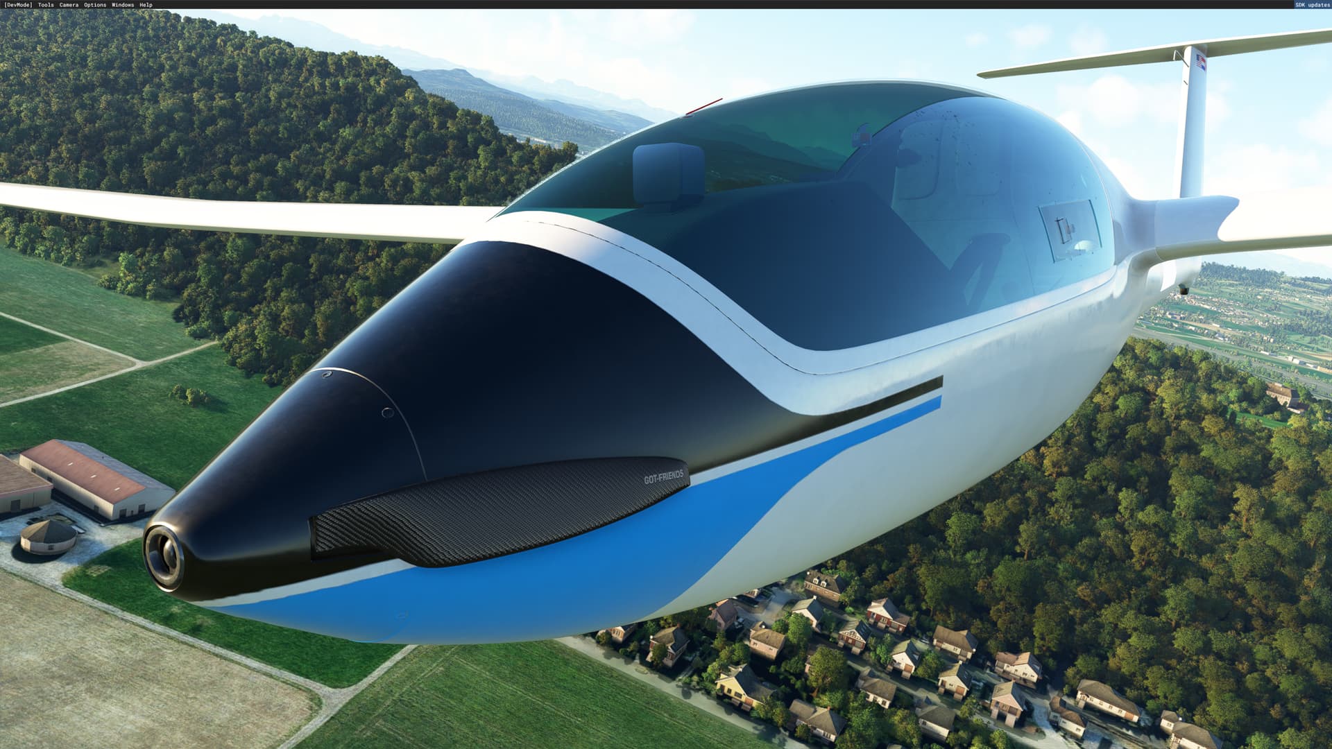
Looks very nice and streamlined! What is it?
EDIT: oh, the Discus? Looks different!
Is that a sustainer engine? nice!
Is this going to be a premium/payware variant?