RNAV approach with vertical guidance, anyone succeed?

I agree that Navigraph is a great product with great features and is updated realistically in cycles.

However if Navblue has the infrastructure to provide even just plates and AIRAC cycles every 3 months, 6 months I feel like that should be sufficient. Especially if its going to be provided as part of the sim.

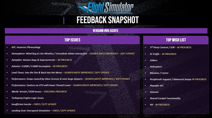
Highly annoying just about covers it, the devs did acknowledge the issue in their latest development update. Thank you wishlist upvoting! It says in progress so who knows how long it will take, hopefully the get the big issues with the garmin avionics out of the way and then continuously update it with the smaller stuff later on.

I’m pretty sure that updated NavBlue AIRAC data for the sim itself will be pushed out automatically. I don’t know if the intention is to do it every 28 days, to keep in step with r/w cycles. The next AIRAC cycle begins Sept 10, which is next Thursday.

There has been no further info regarding the Charts+ service. That was supposed to debut at some point after initial release of the sim. I have my suspicions that there will be a DLC fee for charts, but that remains to be seen.

1 Like

My lack of understanding of the subject kinda foiled the question. Correct me if I am wrong.

I thought RNAV gps approaches referred to approach not utilizing VHF radio navaids which allowed for an interruption of the 3 degree glideslope as necessary for example if you have to fly level at some point to go under a bridge or over a building or through a hole circumscribed by rock to get to the other side of the mountain and then resume the glideslope; or if the glide path itself needed some lateral navigation to turn around something ( I am not really serious about the example scenarios, but I thought certain situations required an approach to deviate from the glideslope) . Of course, those scenarios are accidents waiting to happen and will truly stress the laws of physics ( It would probably work in space where you could use thrusters).

So I thought the vertical adjustments would occur even after FAF.

I think now that both GPS and LOC approaches utilize a glideslope in the same fashion ( just different colors). The difference is probably the source of the data. The ILS via LOC uses VHF radio for navigation while GPS being more modern should utilize all possible data sources. A computer should be able to plot a straight course between points A and B simply using multiple VORs and their radials because it should know where the radials intercept each other (DME makes it even easier) , therefore by utilizing the information from VORs, it could establish the location of the plane along the straight path. So a straight path is possible, without having to navigate VOR to VOR. It would not be necessary for the pilot to figure out where the radials intercept in order to fly to a radial intersection. That is a complicated but fun way to figure out one’s location but it puts a lot on the pilot ( and of course the trend is to reduce pilot burden to improve safety) . Basically input the VOR frequencies ahead of time, then when active, change the CRS, watch AP NAV line you up ( or do it manually) with a VOR radial, fly along its heading and switch to the second VOR and watch for needle alignment when you cross the intersecting radial. This is how using VHF you can plot a straight course. I notice that in the bigger planes, this is not even possible. At least I couldn’t find a CDI key that lets me switch to VOR2. The G1000 will let you do this.

So my question really was applicable not to the approach but to the enroute waypoints where altitude adjustments based on altitude presets will be automatically performed by the autopilot using VNV. And this probably is only a G1000 specific (or Garmin specific) feature. Has anybody seen this working in FS 2020?

Incidentally, I just finished watching DragonSlayer (1981). There is an awesome scene in the end with the dragon flying over the clouds and I wondered how such a scene would play out in the FS 2020 world. Would be awesome. Fly to a interdimensional gate, and then in the alternate version of the world, you will see dragons flying alongside your plane.

Thanks

A GPS RNAV approach depends only on GPS. It does not require any ground-based navaids.

Not all GPS RNAV approaches offer vertical guidance, and not all aircraft are capable of using the vertical guidance for those approaches that do have the option.

Some approaches with a letter at the end of the procedure name eg: “RNAV(GPS)-A” have only circling minimums. These do not align the aircraft with a specific runway. The minimums for a circling approach are usually quite high, because the pilot needs to be in visual conditions at the end of the approach to manually align the aircraft with the landing runway.

At a minimum, non-circling RNAV approaches will have lateral guidance (LNAV) which will generally align the aircraft with the runway centerline.

In an LNAV-only approach, the pilot is responsible for manually controlling the rate of descent. The descent can be done by the autopilot (typically using vertical speed mode), but the pilot is responsible for adhering to any altitude restrictions that may be attached to waypoints that exist between the IF/IAF (initial approach fix) and the MDA (minimum descent altitude). The descent path in an LNAV-only approach will often be a series of “step downs” in altitude, rather than a continuous unbroken vertical path.

LNAV/VNAV approaches do offer vertical guidance, but the vertical descent path is calculated by the GPS or FMS based on the altitude of the initial approach fix, the altitude of the MDA, and the distance between them.

An LNAV/VNAV approach requires an aircraft whose autopilot has full VNAV capability. In VNAV the autopilot will control the rate of descent automatically, and will adjust the descent rate as required based on the aircraft’s speed and position, but it is not the same as tracking a glideslope. The pilot is responsible for monitoring the aircraft’s altitude and descent rate, insuring that the aircraft does not descend below any intermediate altitude constraints on the approach. The altitude selector must be set for the MDA altitude, to insure the aircraft descends no lower than MDA. The vertical mode on the autopilot is set to VNAV (or VNV).

When flying a VNAV approach, there is no glideslope indication on the primary flight display.

An LPV approach has the lowest minimums, and is the only type which is flown using the same techniques as flying an ILS. An RNAV approach with LPV minimums will always show the letters “WAAS” in the upper left corner of the published approach plate.

WAAS is a supplemental satellite signal that greatly increases the vertical accuracy of the GPS receiver. Obviously LPV can only be flown by a GPS with the necessary circuitry to detect and utilize the WAAS signal. (Not all GPS receivers have this capability).

When flying an LPV approach, the GPS receiver creates a pseudo glideslope path, based on its ability to measure the aircraft’s altitude very precisely thanks to the supplemental WAAS signal. The WAAS glideslope indicator appears on the PFD just as it does when flying a standard ILS. The autopilot is placed in approach mode (APPR) to fly an LPV approach. The autopilot can capture and track the GPS-created “localizer” and “glideslope” exactly as it would when flying a standard ground-based ILS.

Although an LPV approach is technically considered to be a “non-precision” approach, as a practical matter, the LPV minimums for a given runway are often identical to the ILS for the same runway. Sometimes the LPV minimums are even slightly lower than the associated ILS!

Most r/w airliners can do an LNAV/VNAV approach, but LPV capability is not as common in airliners. LPV is more common in biz jets, turboprops and piston GA aircraft.

The only way to know for sure what kind of vertical guidance options are available for a specific RNAV approach is to consult the published approach plate.

Since VNAV does not yet work correctly in any MSFS aircraft, simulated LNAV/VNAV approaches are not yet possible. The G-xxxx equipped aircraft do appear capable of doing an LPV approach, but there appear to be some discrepancies as to how the approach is loaded and activated compared to a real G-xxxx equipped aircraft.
10 Likes

Awesome. This provides me a lot of clarity. The magenta colored glide slope in GPS approaches is probably an LPV approach then. This is in contrast to the standard ILS glideslope radio using VHF localizers ( the glideslope radio itself utilize UHF) which is displayed in green.

I think the procedure is the same, pressing APPR when about to intercept the runway heading. The AP then turns off HDG as it attempts to line up laterally. Then when the glideslope is intercepted, AP turns off the ALT hold and descends the plane. in the LPV approach, there is no need to tune into a LOC frequency. Although I read somewhere there is a regulatory requirement to tune and monitor a VOR when landing via GPS.

The terminology is somewhat confusing since I think that both the VHF LOC/UHF GS and GPS style of glideslope approach should be under the umbrella of ILS approaches. In my research though, ILS approach is mostly used to refer to the VHF LOC style approach. Also LPV refers to Localizer Performance with Vertical Guidance. So its easy to associate it with the VHF Localizer.

There’s no way I can press the VNV button and have a meaningful effect at this time.

Thanks

“ILS” refers only to an approach using the standard ground-based localizer and glideslope transmitters.

I don’t think there is any regulatory requirement to use a VOR or other external navaid in conjunction with a GPS RNAV approach, but operationally it’s always a good idea to have ground-based navaids tuned, identified and “ready to go” in a standby mode in case the GPS receiver fails or something interferes with the signal from the GPS satellite.

There is one bug in the current WAAS approach emulation in the sim. When the magenta pseudo glideslope indicator first appears, it is already centered, which is not correct. It should instead show the relative position of the pseudo glideslope to the airplane. An RNAV glideslope should be intercepted from below, just like a real glideslope.

1 Like

Excellent replys @HalberQuacky. The only thing that I can add which would help with @HappyScroll3 's terminology confusion is that when talking about an ILS, glideslope is the correct term when talking about the vertical guidance aspect. With an RNAV approach glidepath is the correct term for the vertical guidance provided by the GPS receiver.

Hope this helps differentiate the two.

1 Like

Hey guys, thanks for the replies.

I just got done with trying a few flights with the A320neo and it seems to have vertical guidance working. It’s not the G1000 procedure but it definitely stepped up the altitude in incremental targets at each waypoint all the way to cruising and then stepped down the altitudes on all the waypoints all the way to final approach on the airport prior to actual landing.

My flight was from Grissom Air Force base to Indianapolis Airport. I took some notes on the flight with the Autopilot anunciations.

  1. Make sure speed and heading are both in Managed mode in the Autopilot panel ( mouse to see the up arrow on the buttons and press).

  2. Turn the altitude selector on the autopilot panel all the way to zero and enable the Managed mode. This will load the first altitude target in purple on the PFD on top of the altitude gauge.

  3. Throttle to TOGA ( full forward ) . Climb and activate the Autopilot.
    MAN TOGA | SRS | RNY (green)
    CLB | NAV (blue)

  4. Reduce Throttle to CLB detent. Watch the autopilot follow all the altitudes in the flight plan all the way to cruising altitude. THR CLB changes to SPEED. I think the space between CLB and IDLE detents in the throttle just sets the maximum power available to the autopilot instead of giving a specific power setting.
    THR CLB | CLB | NAV | AP1
    THR CLB | ALT | NAV | AP1
    SPEED | ALT CRZ | NAV | AP1

  5. At top of descent AP will change to
    SPEED | DES | NAV | AP1

On capturing an altitude and leveling off prior to the next descent:
SPEED | ALT*| NAV |AP1
SPEED | ALT CRZ | NAV | AP1
SPEED | DES | NAV | AP1

I think after the last waypoint I need to press the APPR button. Still working on the landing.

Don’t really know how the A320 autopilot is supposed to work but this is what I observed.

The flight plan can be viewed on the keypanel on the lower part of the cockpit. The Perf button displays the settings for each phase of the flight with settings for managed speed.

There should be a setting that allows a descent with THR IDLE but don’t know how to get that working.

Don’t know exactly when I should switch to APPR. Perhaps after the last waypoint?

I think the throttle should be put to idle to turn the autothrottle off prior to landing and I think I read somewhere that the AP will disengage at a certain altitude. It also cannot be engaged before a certain minimum altitude on take off.

There is an Alpha floor protection that engages the TOGA throttle setting I think when the airspeed is too low and there is a stall imminent. Don’t need that to engage during landing.

I get an overspeed warning if I try to engage the flaps before the final waypoint to the airport. Don’t know how that coordinates with the auto throttle. On the Perf page, in the APPR phase, I think the computer takes into account the flaps configuration for landing so don’t know why it is giving me overspeed, unless, I need to engage the flaps after the last waypoint, not before.

I will be playing around with it some more.

Its important to use an approach chart so you can see the fixes and altitudes of the approach. I press the APPR button just prior to getting to the IF (Initial Fix), I found that the LS button also works but the glidescope only kicks in in the final part of your approach.
When landing, keep the the autothrottle on as it will manage your speed during the whole approach,especially as youre adding flaps. just make sure youre slow enough before starting your approach (usually below 210kts). You’ll notice a little green circle on the airspeed side of the display indicating when youre close to approach speeds. Make sure your speed is in Managed Mode and it will control your airspeed down to the runway.
Other notes. I set my altitude in the autopilot to the nearest hundred feet above the runway and engage the Altitude Managed mode when starting the approach. The plane will descend along the approach to the lowest altitudes per the approach chart (this is why you need approach chart to double check altitudes). If you find that youre too high, use the vertical speed knob to increase descent and the autopilot will automatically level out once youre at the correct altitude for the approach.

1 Like

Quote: “When the magenta pseudo glideslope indicator first appears, it is already centered, which is not correct.”

I have found that if you fly the approach according to the charts, the glideslope indicator will be at the bottom.

I fly RNAV app and when I fly as chart shows, I have in beginning phase glide indicator centered (ready) and if I catch path it goes to litlle up and started descend as is defined. It needs only click aproach button and all goes ok. With Navigraph Beta is problem probably still (it goes fully up and not move) as I as first discovered this issue and guys working on it.

The GS indicator should not be centered (ready).
When flying an RNAV LPV approach, you should have the GS indicator fully up when first turned to final, and intercept it from below, just like the equivalent ILS approach.

So then Navigraph Beta updates work correctly and MSFS system is wrong, better say Navigraph Update doesn’t work, indicator doesn’t move but shows fully UP. This is question to Asobo


I apologize for bringing up an older thread
but is this still pretty much the status quo? RNAV’s are still finicky at best? I tried one last night going into KDDC, which supposedly has WAAS capability, and the glide path just stayed stuck at the bottom. This was in the TBM and I was at the correct altitude per the Jepp approach chart in Navigraph.

Also
can anyone shed light on why some Jepp approach charts say “LNAV ONLY” in their approach profile view, and others don’t say anything at all?

I’ve not gotten VNAV to work, but that said, I’m not really 100% sure exactly how it’s supposed to work either.

However, an RNAV approach is really not a difficult thing. It’s easier than ILS for the most part as long as you follow the waypoints and altitudes on the approach plate. I did this video a bit earlier of an RNAV approach and landing. Simple as can be.

Thanks for the video!

I understand how an RNAV works, or is supposed to work. I just have trouble more often than not intercepting the glide path
even at correct altitudes per approach charts.

1 Like

Yup, hasn’t changed since day 1. Even though all the aircraft technically has WAAS enabled avionics, this doesn’t necessarily translate into the sim.

It sounds like you’re doing everything right in regards to flying the approach and having the correct reference material with your Jepp charts.

On the approach plate the LNAV ONLY asterix is actually quite complex to put into one post. If youre really interested, I found this.

I’ve tried flying some of the RNAV approaches by hand, but the LNAV axis on the HSI does not increase in sensitivity (label ENR, and getting wildly off axis will only show up as a few pixels off centre).
Add this to the list of incomplete things about RNAV approaches

This is excellent information. Thank you!