There have been some absolutely stunning official MSFS flight pictures of various geographic locales, same for many of the pictures posted by forum users. There ought to be an way of sharing the information necessary for another user to teleport to that spot and spawn in the air to enjoy flying about the same area themselves. Perhaps a discrete 'i" in a small solid circle at the lower left or right of an image that when moused over, one could copy and paste the GPS coordinates the aircraft or the drone camera was at when the photo was taken (or see below, perhaps offer an .FLT file instead). To have such a mechanism, the in-game camera mechanics would have to be adjusted. Right now, if one immediately hits the Esc key and saves the flight, one can capture the GPS coordinates a picture was approximately taken at in an .FLT file but hitting the Esc key interrupts the flight and requires a lot of further effort to recover the GPS locale from the .FLT file and then there is no official way to include the picture locale in publishing the picture on the forum.
A simple approach might be to include a utility for the sim that extracts GPS coordinates (and other information about the flight?) from a .FLT file and incorporates it into the EXIF data of a .JPG picture (and have the tool then work in reverse to create an .FLT file for another user with EXIF data from a posted picture).
Or maybe just find a way to easily and automatically generate .FLT sidecar files for pictures as they are taken and a mechanism for associating .FLT files with picture posts on the forum (with forum software smart enough to ban phony .FLT file posts). Already an .FLT file saves most of the information required to recreate a moment in flight. But it’s not automatic and it doesn’t take the viewer upon reloading the .FLT file back to the exact camera view in use when the .FLT file was saved. So perhaps the only sidecar automation required is to make saving an .FLT file a smooth and automatic option choice and include the information in the .FLT file to recover the camera view from which the picture was taken. Then on loading the .FLT file again in-flight while paused, one could work on manually improving the original picture, if one wanted or just go flying about that location same as the person who originally generated the picture. Then there would just have to be a mechanism for other users to capture or request such .FLT files from posted pictures.
Part of the fun of MSFS is the flying itself. Another part of the fun is the awesome scenery views that often result. I’m just suggesting improving the ability to share scenery locations easily when they’re something much harder to find than KJFK
The thought of moving lat/long from a saved flight to EXIF data in a screenshot is a really interesting one. It’s definitely going around your you-know-what to get to your elbow, but I knida want to make it work just for the heck of it.
@ModeratorTeam I’d like to suggest adding “.FLT file” as a forum tag - or some other tag description that covers regenerating and sharing aspects of a flight/camera view from saved information.
I guess this would be possible using the SDK/simconnect. Watch the screenshot folder for changes. If a new screenshot was captured, get the current location from the sim and add it to the EXIF data of that screenshot.
Great! Still hope that Microsoft & Asobo will consider building such an (optional) tool directly into MSFS since sharing screenshots seems to be a big part of using the sim and seeing a “Wow! I’d like to fly there!” photo but not knowing where to go is kinda annoying.
With so many amazing images of the scenery and locations on this forum and elsewhere, I’d love to see an internal MSFS screenshot function that could record relevant and interesting metadata – the location coordinates, time of day, altitude, speed, airplane, etc.
It would make keeping a visual record of your flights and trips a breeze (on any number of photo services which use geolocation), and could be used on forums like these to automatically show where and when shots were taken.
It would also mean they could provide easier and more comprehensive options for showing and hiding the UI, or including metadata, for screenshots.
I like the idea of screenshots but identifying the location of an area on earth is somewhat problematic after the event. Can we please have as an option appended to the screenshot the longitude and latitude to the save image.
As an afterthought others might like altitude, bearing etc.
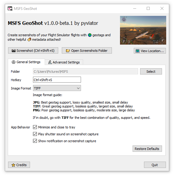
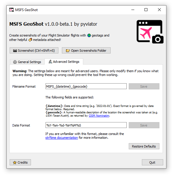
I’ve been looking for a way to geotag my screenshots for a while now and a couple of weeks ago I finally decided to sit down and write a standalone program of my own (inspired by @txt0335844’s tool!). The result of this is MSFS GeoShot: