No you are using a limited definition of aerosol. An aerosol is either a particulate or liquid suspended in a gaseous medium. In MSFS case water droplets in air.
What may work is to have weather condition presets, that translate your descriptive terms into aerosol/cloud settings so that you can drive things top down, rather than bottom up.
But mist, haze, fog are all words that describe different conditions of water droplets suspended in air. From a weather simulation perspective they are just different aerosol densities.
I’ve edited my reaction indeed, its not clear to me what aerosols it controls. In any case it doesn’t give us the option to accurately control visibility / RVR. Presets would be an option indeed.
I am curious how the weather model in FS2020 actually works. I doubt it accurately calculates environmental lapse rates, dewpoints and therefore cloud bases and tops taking into account condenstation nuclei. I assume it just tries to accurately represent the imported weather in the form of METARs and UWT charts.
Interesting that an RVR setting was EXPLICITLY mentioned in the IFR discovery video
Other threads speculate that the weather system is still a work in progress and explains the current situation.
I find it interesting that a feature that is currently missing was so prominently mentioned in a video… why would they do that if they had no real intention of implementing such a thing?
Sorry if this has been mentioned/referenced to already. With so many conversations it’s hard to remember what has been said.
That’s a good question. The manual control obviously allows us as users to set things up as we want and leaves it to us to judge what settings give the effect we want.
The translation of the METAR into specific values is presumably based on some look up tables from the METAR codes to densities and cloud levels taken from the report (might even be in a readable config file; I haven’t poked about in the files that much yet), but I’m not sure what weather source they are using, so their information may be delivered in a form that more readily translates to the weather engine.
At least in the USA –
ALL major airports, and many of the smaller ones have ASOS/AWOS, most of which have visibility measuing instrumentation, to give RVR measurents, that are used in Metars as well as ATIS.
So the Visibility info is more than available from this, and many other NWS services.
Lots of time & effort spent on Aircraft Modeling and Aerodynamic, (that so far, seems to have resulted in many Unflyable planes), fancy scenery, and lost of other “Game Play” features, but then they completely ignore Visibility !!!
… really - Lost for words (that I can post here !@!)
REX is one of the big names in Weather .. were they not able to be communicating with MS during the FS2020 design & development.
Unfortunately one of the limitations of the voting plug-in is that votes do not combine when we merge threads. So we have been quick to close some duplicate voting threads to help direct attention to the main one.
So in cases where there are similar threads, best course of action is to pick the most popular one and vote there. Or vote on all if you feel strongly about it! But feel free to send us a message if you see voting threads that should be combined. Thanks!
(from what I can tell, this linked thread seems to be the one with the most votes concerning visibility)
Well not much things from the “feature discovery series” really lived up to the hype so far so I’m not surprised, IFR being the biggest joke of them all.
To be honest, the ATIS often says Visibility 3 sm, few clouds at 600, 4300, 11200 ft (or something in that ballpark) for me, with no bearing on the actual conditions in the sim. Visibility itself works fine, just not the implementation it seems.
The ATIS also reports weird temperatures for me lately, with the dew point sometimes being higher than the actual temperature. This should be all but impossible under most conditions.
Edit:
Okay, I know see what you mean, OP. Indeed, for me it’s either low vis in clouds or perfect visibility. No haze or anything.
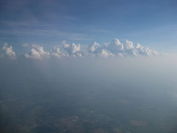
Not my case, it is simpler than that and the other way around imho. GIVEN that the actual clouds representation in game is not working correctly to provide any visibility degradation other than when flying through them, which of course won’t work well to depict something like this (due to the fact that DENSITY is fixed and thus tied to cloud layer thickness):
Some of us are asking for a “cheaper” way to get the results of the image above, even if that’s not the most realistic way of getting reduced visibility at higher altitudes, kind of what FSX has.
But of course, I’m looking for max realism, and if haze/fog at higher altitudes is due to clouds (condensed water), which is, then we need the hability to control DENSITY so we can set a cloud layer with thousands of feet but with the desired level of density (in this case higher or lower depending on the amount of visibility we want).
The result would probably look similar to real life pics but also, it would be based on real life behaviour, it would allow for localized volumetric haze AND it would be working in live weather as there would be possible to use clouds formations to depict haze and thus low visibility.
I would say the visibility is too low sometimes. If rain is in the area IRL, the sim displays much worse conditions visibility wise. Not a problem as it’s a nice change.
I know this was somewhat asked during the original developer Q&A. Might be worth getting some clarification on their response. The next Q&A is a little over a week away. Questions can be submitted (and voted for) at this thread:
At first, I thought this lack of visibility was do to time constrants. The more issues I see with the sim, since early Alpha, leads me to believe this has to do with ignorance in aviation above the private pilot level. I’ve been in aviation for 32 yrs in the real life and I have never heard the word “aerosol density” used. I’m sure its an engineering term used by a few meteorologist. I’ve come to the conclusion that the people in charge of development simply do not have the knowledge beyond private pilot level and it shows in all aspects of this sim. I had faith in the Devs for a while, but I can no longer defend Asobo. Take a look at the outside icing simulation and it is clearly evident they know nothing about how ice forms on a aircraft.
We as simmers and pilots need the ability to lower the real sim world below a “few miles”, as was stated in their “aerosol density” response statment. We need 0/0, 1/16, 1/8, 1/4, 1/2 and 3/4 mile simulated look ability, no matter how or what they want to call it. One mile is about the lowest this sim goes with every slider option available and this barely gets to real world IFR. One mile, clear of clouds is still VFR in some airspaces. Now that they got the “live weather” function somewhat working, I spent a few hours going to every place I could find where the weather was reported below 1/2 mile visibility. What I noticed, none of this works correctly in the way they claimed in works in “real life” compared to the simulated sim world. The live weather sim visibility is still above the 1 mile mark at all these areas when reported below 1/2 mile. The clouds are just too transparent. Asobo, where is the visibility and RVR adjustments you promised in “Module 8, IFR”?
The reason that most everyone is so up-in-arms about the “live weather” situation in general is that for a flight simulator, weather is really the only dynamic content in the game. Where the mountains and oceans and cities are is kind of fixed. The aircraft are fixed. Even the “live traffic” is fixed in my opinion since you don’t interact with it, or it with you. Weather on the other hand can change, and does affect the main thing in this game - your flight. It also can visibly change the landscape. Think about how boring a flight simulator would be without any weather at all.
So far cumulus clouds may be the best-delivered feature of the entire game. It is absolutely imperative that Asobo expands on that and delivers the best and most all-encompassing weather experience that is possible.