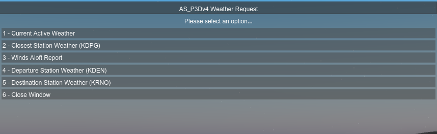
It’s useful to know far enough out so you can choose the correct arrival procedures and right now I know of no other way to ascertain this in MSFS. It’s from ActiveSkyNext for Prepar3D:
The workaround is to get the ATIS/ASOS information for Destination and tune it into the second NAV radio. You may need to disable VHF degradation, and if the sim is simulating realistic VHF ranges, it may not pick up until you’re within range of Dest. I do this all the time in flight, since I have an external EFB that has all the COM frequencies in-sim.
1 Like
Thanks for that but I know in P3D that was an issue until I discovered what I posted, not being in range to pickup the destination ATIS. What’s your sense of distance from dest in MSFS? Also, for a sim on Xbox, to me a built in interface as posted would be the best option IMO.
So far, it’s about rule of thumb for what you would expect VHF LOS to be. At mid-altitudes for Low IFR, say 10,000’, it’s probably picking up at about 100 miles easily. I’ll check in sim as I’m about to try a Low IFR 300nm range flight.
1 Like
Well that’s hopeful I’ll give it a try, and can use LittleNavMap, which I use for everything else and i see now it does include ATIS freq. Thanks ;o)
Well, I picked up ATIS at a major international airport at a direct range of 60+ nm at 15,000’ cruise. I could have probably tried sooner, but was getting a STAR set up in the FMS.
1 Like
Well, if you don’t mind please vote on it. It’s a minor feature, very easy to code for, and will help those newer to the game.
When do I make COM 2 active, or is it active by default? I do have the correct ATIS in the Active field, and I see in the ATC window tab, the COM2 tab says Not in use, and I am about 300m from destination.
I would suggest changing the Name of your thread so its more obvious at a glance (in that long list of issues & requests).
I had to click on your thread to see exactly what you where talking about.
Great idea though, we really need something like that
1 Like
I did, but reminder - no voting solicitation!
To other user’s point, changing your title to more succinct, focused topic will attract more interested users easily.
If the tab shows the desired frequency, it’s tuned. It’s just a matter of range at that point - that may be why it says Not In Use.
Would be kind of nice to see this on the world map before you even enter a flight.
I have tried to use the Windy and other online weather services but they haven’t exactly matched up with sim weather in the past.
2 Likes
The sim uses Meteoblue, so you can try to derive from that for destination. There aren’t any really good, easy workarounds.
Thanks, I don’t think I actually entered that title! But I just now changed it, thanks you’re right;o)
Here’s what I do. Flying into SFO.
Go to Airnav, Flightaware, Skyvector or any other LIVE aviation weather source and get the metar and enter info into FMS while in descent.
As MSFS 2020 “LIVE” weather is usually about, 8 hours behind …and… the ATIS does not always match the sim’s “LIVE” weather injection, I switch to the Unreal Weather mod some where down low on the STAR before I enter the approach. That way I have LIVE weather that’s actually LIVE, no matter the time of day in the sim.
^^^^^ I think there are. Hopefully, we can get an improved weather engine soon as it is a very important aspect of aviation simulation.
I do this too.
1 Like
I think everything you are asking for is available from the World Map using the various filters. I often use the wind speed info at the airports I use. It is possible to view weather using a satellite, IFR, or a blend background. It is possible to display areas of precipitation or clouds. Also, winds speeds for airports can be displayed for ground, low level, and high level. Lots of information is available on the World Map.
Of course, the info isn’t as detailed as SimBrief which has very comprehensive weather information custom tailored for your flight.
A while back I made this concept image for a post about getting weather on the map.
I’d like to be able to click on an airport in the planner and receive the sim weather prior to planning a flight, that way we can alleviate some of the guess work out of flying to various places. I know we can use websites to get the weather but there is quite often a disconnect with what is seen in sim.

It unfortunately does not solve the problem of what the weather is now, in flight, especially if it’s a longer flight, and even more so if and when weather updates happen more frequently. You can get a clue of what the weather was as you’re flight planning, certainly looking at wind at a specific runway which matters the most in terms of planning an arrival procedure. But on long flights it changes, so isn’t very useful anymore. I simple pop up panel window reflecting current weather at the destination airport guarantees you know the actual weather, and what a coding piece of cake to product.
Vote, it’s a no-brainer!!
Pilots use Terminal Area Forecasts to help determine what the weather will be. Unless one is flying in Tornado Alley, weather changes are very predictable because weather is always moving from point A to point B, sometimes slowly, sometimes quickly. Meteorology is covered in depth during ground school for private pilot and instrument rating. Not only do pilots get “a clue” of weather during flight planning, it is REQUIRED in order to choose an alternate airport and to insure the weather at the alternate is better than minimums. Pilots have to plan their flight and fuel required based on the assumption that the destination airport will be closed. This planning isn’t done 30 minutes before arrival.