VATSIM Altitude Disagree with In-game Altitude

Background info:
MSFS Version: 1.21.18 (latest update), XBOX (MS Store) version
Hardware: PC (Windows 10)
Developer mode: NO

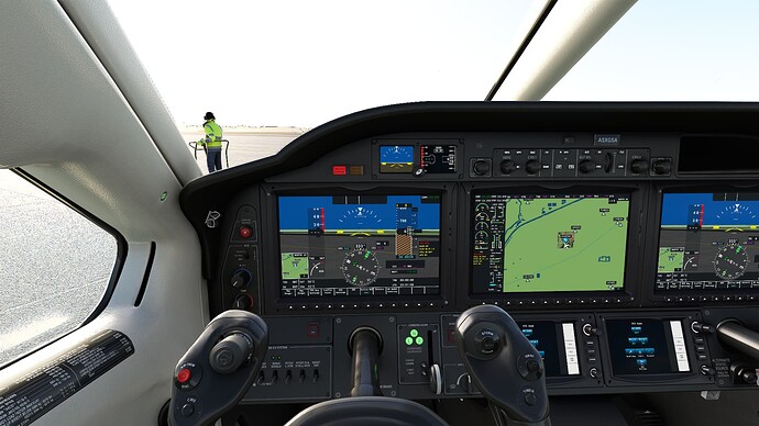
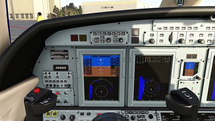
Issue: in cockpit, I show FL350 and STANDARD altimeter. VATSIM reports an altitude nearly 1000’ lower than that, and I’ve had TWO instances where I passed within 200’ of another aircraft who was supposedly 1000’ below me.

Weather pulled from MSFS matches weather report by VATSIM (altimeter setting does, anyway).

Screenshots attached.


Any ideas?

Known issue - reasons are complex - and despite attempts to fix the issue, it looks like its still SUBAR.

I really though by now it had been figured out and fixed, but that would probably require Vatsim & Asobo to Communicate, and from the little I have talked to the Devs at Vatsim, that communication is not there.

Seems to be a familiar pattern … :unamused:

I fly GA below FL180 on Vatsim, so it is not such big issue for me - and so I don’t really care to get involved in something I have no control over…

1 Like

You might try a manual setting of the 101.3 or 29.91 instead of “STD” I don’t know if it would help though.

Tried that, did not change anything.

1 Like

KMDW on the ground shows 0 on the altimeter when elevation is 670!

For default aircraft pressing B works but you can tune atis to get the correct qnh and set manually. I don’t know about 3rd party aircraft but if they aren’t working correctly it’s down to their devs to fix, not Asobo.

Both the Asobo TBM and Longitude indicate the same altitude, 0 when the barometer is set correctly.

I verified the barometer setting with ATIS, REX and NOAA. All 3 confirmed I had the correct setting. Very strange. I can’t remember when this started.

TBM

Longtitude

The 30.80 qnh matches in atis for both … I guess it’s an addon causing your problems.

That’s not the bug we are talking about.

It’s the so called “bug” in the post I was answering.

Thanks. Appreciate the info. I’ll start trying to narrow it down.

1 Like

This is happening below FL180 also, when barometer is set to local pressure. Pressing the B key does not help. Flew last night with the C208B and altitude shown on VATSIM was 500’ lower than the altitude showing in MSFS.

I have been having this problem for some time now when I have been flying online. For the last few days in the UK the qnh has been high about 1035 when I set the vatsim qnh I to am about 500ft out. if I set my qnh to about 1025 it reads the same as vatsim so I have been setting my qnh to the level that matches my altitude on vatsim.

Is there a source for a detailed description of exactly what this issue is, what is causing it, and what can be done to make it workable on the ATC networks.

I am now totally confused, but get the impression it is due to MSFS unique simulation of Pressure vs Altitude with REAL weather.

The effect does NOT seem to be their if you set a Weather Profile with the same Altimeter setting as used in Real Weather.

While it is very cool to better simulate the pressure/altitude relationship, taking into account variable like temperature , Humidity etc, if currently the other Sims (XP11, FSX, P3D) are not doing so, (and not likely to in the near future), maybe a work around is an “option” when on ATC networks, to run MSFS in the less realistic mode (like other sims), so everyone matches …

I will resist further comments myself on this, till I read some better description about the subject …

1 Like

I’ve been meaning to try this myself. Do you know if the difference is always off by 10, or does the difference vary depending on the pressure?

This last week it has been 10 but Im not to sure weather it will be 10 if the gnh is lower. I used to just keep the sim and vatsim the same but the diffrance all the time started to annoy me so now I just match the my vatsim alt on little nav map and adjust my alt in the sim gnh to match. It has stopped the controllers always telling me about my altitude. The only pain is I can not be on the gnh that the controller tells me.

1 Like

So, this is what’s interesting to me: My flight plan is for 36,000 feet. My aircraft shows 36,000 feet with STD altimeter. The controller says he sees me at 36,000 feet. However, my reported altitude on the VAT-SPY map is much lower (say, 35,200 feet) and a few times I passed within 200’ of someone who told me they were at 35,000 feet (and they saw me that close as well). So EITHER MSFS is putting VATSIM traffic at the wrong altitude and reporting the wrong altitude to other sims, or there’s some other disconnect that’s not working.

I’ll take a go at an explanation, making it up as I type !! (not going to take hours to edit it )

Your Altimeter is set to STD Altimeter setting, so the altimeter display which is really reacting to pressure and measuring pressure, display it on a scale calibrated in Feet.

In MSFS. unknown to the Altimeter, that Pressure at a Given Height above ground, is also varying with other factors, like temperature & humidity, which the Altimeter is unaware of.
(Thank you MetroBlue fro better weather information)

Therefore for a given pressure, it is displaying an altitude that is also a factor of both Pressure, as well at temperature and Humidity.

In the Real World, this is what happens, so the absolute height above the ground when you display a Given altitude will vary because of the temperature & Humidity variations, but that does not matter so much in the Real world because ALL Planes near by are experiencing the same variation, so all planes say, displaying 36,000 are flying at the same altitude, even if its not exactly 36,000 ft.
(t when down at the airport, they will be displaying the CORRECT Altitude, because that where the Altimeter setting was derived from) :+1:


In the SIM world, MSFS is now calculation this variation of Pressure taking into account Temperature and Humidity, so all MSFS fly at the same relative height for a given calculated pressure, but other sims are not doing this same correction, so their planes, when their Altimeter is display 36,000 , while all flying at the same height above ground, and NOT necessarily flying at the same height as the MSFS planes.

SIM Planes send their Altitude* values to Vatsim, but while all plane XP, P3D, MSFS think they are at the same 36000 ft, they are NOT, because MSFS is the odd one out and is modifying its pressure model with Height above MSL.

  • They should be sending their Transponder FIXED Std Pressure data to ATC, and ATC should be doing the necessary calculation based on local altimeter setting (but that is irrelevant here) - The Vatsim Radar Client is not going to do that ???

This modified pressure is a better realistic simulation for MSFS, making MSFS “Better”, but is now DIFFERENT to what other less realistic sims are doing.

Possible solutions are:

    • MSFS has a way to disable this more realistic processing when on Vatsim (PE etc)
    • Other sims calculate pressure vs height above MSL the same as the more realistic MSFS, by somehow getting the MetroBlue data and making the corrections the same as MSFS
      ( Cannot see that Happening !! )
    • Vatsim , and PE “somehow” get the same MeteoBlue info as MSFS, so it can do the same calculations as MSFS and make corrections to the Non MSFS Planes
      ( Cannot see that Happening !! )

So #1 would appear to be the only workable solution ???

##############################################

I may well have some things wrong here, but it is a start of an explanation, – feel free to improve on it where I have made incorrect assumptions.
(* I welcome POSITIVE corrections*)

A side note: If you do NOT use real weather in MSFS, but set the weather to STD Pressure, when you are above FL180, then MSFS has no MetroBlue data to modify the Pressure profile , and you will appear at the same Altitude as plane in other sims other Sims, displaying the same ALTITUDE.

4 Likes

Not exactly correct, but you have the gist of it. Humidity doesn’t enter into it at all, it’s the change in pressure variation with altitude that MSFS now takes into account that other sims do not. The result, however, is as you described, that an MSFS airplane’s height above mean sea level will be different than a non-MSFS airplane’s height above mean sea level (unless the actual pressure gradient is the same as the standard day pressure gradient).

VATSPY, the VATSIM website, and other 3rd party apps always show the airplane’s height above mean sea level, which is different than the height shown on the airplane’s altimeter unless the QNH is set and either the atmospheric pressure gradient is the same as the standard day pressure gradient, or the airplane is at the location where the QNH was derived.

After all the claims from people that MSFS is more of an arcade game than a simulation, I am not in favor of “dumbing” MSFS down in this respect so that it fits in better with other sims that do not simulate the atmosphere and airplane altimeters correctly.

There is another solution described here for how these other sims can be accommodated by VATSIM and potentially other online flying applications - VATSIM / IVAO / PILOTEDGE Users - Be aware of an important bug! - #363 by BTVPilot

6 Likes