Neither VATSIM nor the MSFS built-in ATC seem to be using indicated altitude. Otherwise, why would both be telling pilots they are at the wrong altitude when the autopilot is holding the airplane at the indicated altitude?
1 Like
I guess part of what makes this confusing is that if by some bizarre event temperature was really ISA + 80 degrees whatever insane weather conditions caused that would probably also affect the pressure somehow, so it is odd to see the temperature change by fifty degrees and pressure stay the same. That is all fictional anyway since such conditions would not occur IRL.
It might just be my opinion, but while it would be wild if the sim could simulate the temperature error of altimeters that seems to be lower priority than all the other issues discussed in this thread.
I still would really love to know what actually happens when I press B below 18000 ft. Do I get local QNH at the nearest airport? Some smoothed QNH from a combination of nearby airports? Do I get local QNH at a fictional airport at my exact position but located at sea level - probably not, since then I would never see airfield altitude at a local airport if that airport elevation is significant and ISA temp deviation is high?
One way to find out would be to find some place where there are two airports close to each other at different elevation and see what happens. Like that classic textbook case of a 5000 ft cliff right by the ocean with one airport on the cliff and another airport on the beach both reporting different QNH…
1 Like
As I understand it, different altitudes for two airports nearby would not cause a different sea level equivalent pressure at the two of them, unless the edge of a high or low-pressure zone was directly above one of them and not the other?
It does though, that is why it is a fun textbook trivia example… : )
QNH is station pressure reduced to sea level pressure assuming ISA pressure lapse rate, which is different from the real pressure lapse rate in a non-ISA atmosphere. Done that way since the altimeter is calibrated for the ISA lapse rate. So setting QNH for the 5000 ft airport means the altimeter will read 5000 ft at that airport but it will not necessarily read 0 ft at the sea level airport, and vice versa.
2 Likes
So are we back to “it’ll be off by X feet” where X is anywhere from 10 feet to 1500 feet, and there’s no way to predict it without knowing the temperatures of both stations? 
Just seems surprising that there’s that much inaccuracy in altitude instruments! I thought the use of barometric calibration was to help prevent hitting terrain. 
Yeah well as the experts point out above for the most part it does not really matter… Except for terrain clearance in cold temperature where the altimeter reads too high and we need to apply manual temperature corrections to the indicated altitude. For aircraft separation it does not matter at all as long as all altimeters have the same systematic errors, which they do by design.
2 Likes
nod makes sense 
adjusts expectations of general accuracy for the future
Sorry, I haven’t read the full thread as it’s 108 posts all of a sudden.
Do you have an idea why the pressure altitude and indicated altitude disconnect at non-standard temperature? It seems the altimeter is reading correct now at field elevation which seems to be a workaround for part of the problem rather than a fix considering the altimeter still does not read pressure altitude when 1013.25 / 29.92 is set.
When standard is set indicated altitude = pressure altitude! Do you know if the problem fully understood by the devs?
The temperature should affect the atmosphere itself (pressure lapse rate) instead of being a correction applied to the altimeter. I haven’t tested it yet but it sounds like with QNH 1013.25 / 29.92 and baro set to standard, slewing the aircraft to 10.000 ft pressure altitude and then changing the temperature, only the indicated altitude changes while the pressure altitude remains the same (as before the patch).
1 Like
Apart from the fact that indicated altitude = pressure altitude with standard baro set.
It depends on the baro, if 1013.25 / 29.92 is set the altimeter reads the pressure altitude no matter the current QNH.
1 Like
This hasn’t been fixed via the hotfix/update yet, has it?
Effect of Pressure and Temperature at Aerodrome Level
I’ve run some test at aerodrome level (at Quito intl.), these are the results. I will run some test in flight later. As can be seen, temperature does not effect the altimeter reading at ground level with correct QNH set which is as it should be. The altimeter adjusts really slowly to changes in pressure, if I let the sim run for long enough I think all indicated altitudes would read the same eventually.
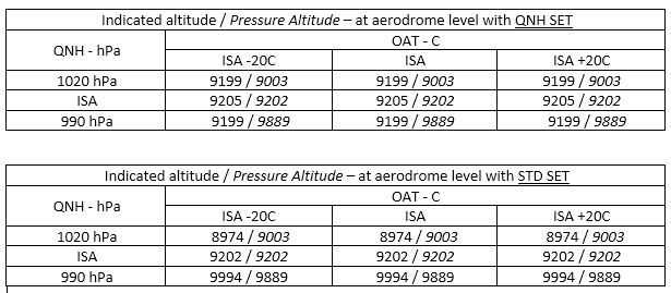
In the second table altimeter is set to standard meaning the altimeter should read pressure altitude (indicated altitude = pressure altitude). Unfortunately this is only true at ISA pressure for some reason.
Effect of Pressure and Temperature at 20.000 ft
Slewed the aircraft to 20.000 ft in ISA conditions, active pause, changed temperature at standard pressure resulting in the table below:
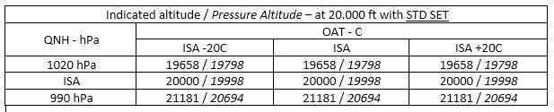
I assume with active pause the aircraft is kept at the same position in space (height above ground) in which case the effect of temperature seems to have disappeared after last patch.
Effect of Temperature on Indicated versus Radio Altitude
Slewed the aircraft to 200 ft RA above the runway surface at standard pressure, active pause resulting in the same indicated altitude:

Also wondering where this fixed ISA -4C indication on the G3000 is coming from.
I don’t know if someone can confirm but the temperature effect on altitude seems to have disappeared after last patch! @AwarePlot117729 Can you confirm?
2 Likes
Yes, I could have worded that better. I was referring to the simulator specifically.
By definition, pressure altitude is the altitude displayed when the altimeter is set to 29.92. MSFS provides several simconnect variables relating to altitude, all of which can be monitored with the SDK sim var watch utility program. The variable PRESSURE ALTITUDE gives the value that would be displayed if the altimeter was set to 29.92. It will differ from the variable INDICATED ALTITUDE if the altimeter is synced to the current barometric pressure, and that pressure is something other than 29.92. If the current pressure actually is 29.92, (and the altimeter is synced to that pressure) then the two variables will match.
The point I was trying to make is that seeing different values for pressure and indicated values is not a bug if the current injected barometric pressure is not standard, the aircraft is flying below the current transition altitude and the altimeter is synced with the B key.
In my own sim flying, when using Live Weather, I habitually re-sync the altimeter with the B key every few minutes if not flying at the flight levels. In real world ops, if flying with ATC guidance, the controller will give the current altimeter setting. I don’t use MSFS ATC myself, and I don’t trust the accuracy of any ATIS reports from nearby airports
Unfortunately it was not fix not with that hotfix as indicated.
Yes, the temperature effect has been removed. There have been two changes: previously the FSX era code would just use the rule of thumb of 1000ft per 1inMg for pressure alt. It would look up your true alt, check the diff in SL pressure vs std, and apply a diff to your true alt using that diff times the rule of thumb. The was not really a very accurate method, and obviously assumed that you right on the ISA pressure lapse rate curve, which may no longer be true with the live weather system.
The first change was that a new formula was added that is more accurate (the actual ISA pressure alt formula). Secondly, your current local ambient pressure is now used as an additional modifier, so that error from being off of the ISA curve is now also modeled. Unfortunately the pressure data does not have sufficient resolution to drive the altimeters directly, so we still back into this using the geometric altitude (which has a ton of precision), but it should be much more accurate in most cases.
However, I believe I’ve tracked down the issue with the pressure altitude simvar. Unfortunately, due to the platform being on two+ decades of legacy sim code, sometimes you encounter these issues. The pressure altitude simvar gets its altitude from a totally different spot and with copy and pasted altimeter code (which matches the old code). Also double unfortunately, the ATC uses this value and not the one from the pitot static simulation. ATC has a buffer of 250 meters before it yells at you, but with the wacky data being seen in the sim, it’s more than possible to get that big of a diff from the two formulae.
We should be able to rectify that but I need to talk to Seb on Monday about it further.
-Matt | Working Title
7 Likes
But geometric altitude is above WGS84 ellipsoid? Not mean sea level? I didn’t check pressure altitude versus ambient pressure, I should have crosschecked that also, so basically with the baro set to standard the altimeter reads the correct pressure altitude now and the pressure altitude from simvar is incorrect?
Much appreciated you are looking into this!
By the way did you saw the fixed -4C ISA deviation on the G3000? Is that a problem with the default aircraft or the WT G3000?
The geometric altitude 0 should match mean SL the way the sim works, I believe.
That is correct, yep! Previously, your pressure alt would always read the same no matter the local pressure, as long as SL pressure wasn’t changing. Worse, if SL pressure was standard, no diff at all would be applied and your pressure altitude would reflect exactly the geometric altitude, no matter how off your local pressure was from ISA! This is what the simvar still shows.
That I’m not totally sure about, I’d have to go digging a bit and try them both.
-Matt | Working Title
2 Likes
The only MSFS G3000 aircraft I fly regularly is the TBM, and the ISA display has been that way since the sim was released last year. It is simply showing the standard ISA temperature for the current pressure altitude. Perhaps the real TBM works this way, but that seems unlikely, since in most aircraft with an “ISA” display, it will show ISA deviation - the difference (plus or minus) between current TAT or SAT and the standard “expected” ISA for the current pressure altitude.
Since most aircraft performance charts are written in terms of +/- ISA deviation it seems strange that Daher or Garmin would configure the G3000 in the TBM to just show standard ISA. You can work out the deviation in your head by comparing the two values, and mentally adding or subtracting, but that seems an unwieldy way to do it.
Oh ■■■■ you are right, I thought it was finally fixed since it showed such a low value, totally forgot that I was at >9000 ft at Quito intl ![]() .
.
Yes it must be a bug, I’ve never seen it being implemented like that in real life. ISA deviation is what you want to know, the temperature it would be in ISA is quite useless…
@Bishop398 Sorry, its the same bug that has been there already from the start, forgot that I was testing at > 9000 ft, I thought it was finally reading the ISA deviation but seems like its still displaying the temperature it would be in ISA conditions.
1 Like
Thanks Matt!
So, do i understand correctly that the altitude shown in the aircraft altimeter is correct, but ATC has an incorrect value and the simvars too? So when i fly on VATSIM, the ATC would have a wrong altitude from me displayed, while i am on the correct altitude?