Essentially yes. In-sim ATC uses the simvar, which is using the old wrong method. I believe VATSIM also uses the pressure altitude simvar, so this would also apply, but I admit I’m making an educated guess about their implementation.
Thanks matt, for clarification and explanation and getting on the fix, hopefully soon. Im gonna test with vatsim now, atleast there is a bit of hope it will work. Ill report back, guess this a big thing for us online network flyers if it would be correct again. But i would guess that it uses simvars, could not imagine what else…
Just to be super clear, the simvar problem is not yet fixed! So you’re likely to still get yelled at by ATC, if it is sufficiently different.
And to everyone else following along, here’s an example of how wrong the original FSX method could be: if SL pressure was 29.92, and you ended up at 4K ft in some weather that also made your current local pressure also 29.92, the pressure altitude would still show as 4K, instead of 0! To be fair, this example is really unrealistic, that would be one hell of a high pressure system, but it illustrates the problem with the original calc.
Matt, thanks so much for communicating openly and clearly about what’s happening in the internals and how you’re all working to fix it. I really appreciate it as a user and a customer! This makes me very happy.
The main reason I think VATSIM uses the indicated altitude simvar rather than pressure altitude, is that the latter would cause major discrepancies unless everyone (Vatsim ATC and all connected pilot clients) are on exactly the “same page” in terms of what the current barometric pressure is. Since VATSIM hosts pilot clients on multiple sim platforms, (FSX, P3D, X-Plane and MSFS), using a broad variety of weather injection software (or no real weather at all), this would be a source of massive confusion unless the controller simply sees each aircraft’s indicated altitude.
I suppose only someone familiar with the Vatsim network protocols or client software internals could answer that question. I do not currently have a Vatsim client installed for MSFS, but perhaps I will give it a try. One way of determining which value is used would be to monitor the various simvars for altitude while in flight, and ask a controller what Mode C altitude they see to compare which one matches.
I see that’s already been answered. I don’t bother posting all my findings here since it is typically met with skepticism and unnecessary back and forth. I had already provided info to Matt showing that the indicated altitude is correct and the pressure altitude incorrect with baro set to STD. I’m glad to see that his response here is a bit different and that there is a possibility for this to be fixed.
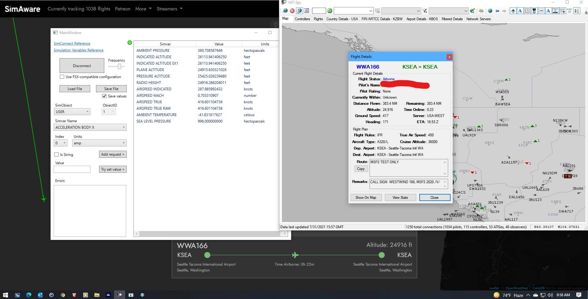
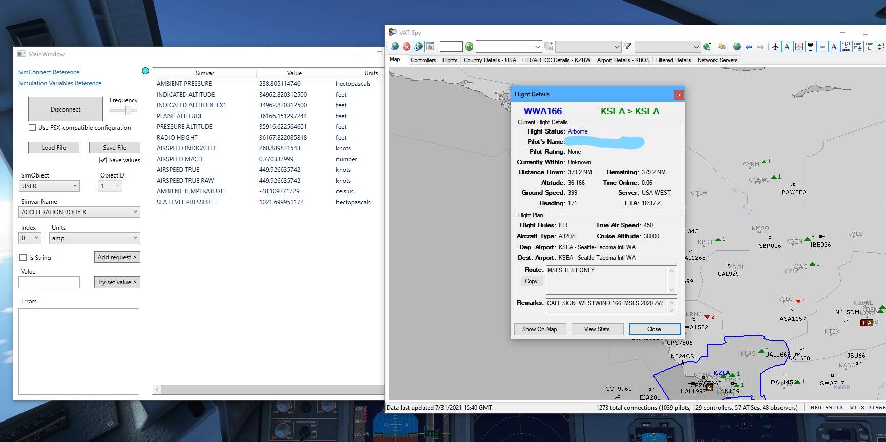
As for VATSIM, I think I’ve already established why it is extremely unlikely that it is indicated altitude that is being passed on. After some more testing, I’ve found that both VATSPY and the online map at VATSIM show the same altitude as the “plane altitude” simvar. I find this very interesting as it will only be the same as the indicated altitude when baro is set to the actual QNH. So with baro set to STD above the transition altitude, it will always be off unless pressure is actually standard at sea level. (Note: This is not definitive regarding what VATSIM ATC sees.)
I use the Clear Skies preset and it works on the network, just don’t adjust your altimeter when the controller gives you one but read it back for the sake of consistency on the network.
Using clear skies on ivao or vatsim isn’t allowed and just puts you even more way off of where you are supposed to be. But anyway, if I need clear sky to put my altimeter on standard, it just mean that the local altimeter is the standard one. So I’m back to my question : do I just need to set the local altimeter to be seen at the right altitude by atc?
Since when is it not allowed on VATSIM? I’ve been on the network for 10 years and I’ve never heard that. As a temporary fix setting clear skies works, I did a few flights yesterday and it worked. I even checked in with controllers. Simply set clear skies and set it to 29.92 inHg or 1013 mb and it works.
I’m doing the ivao tour and it’s not allowed. But it’s not the point, if I need clear sky to be seen at the right altitude, it means it’s a qnh problem. So back to my question: setting the local qnh instead of standard would it prevent me for being seen at the wrong altitude ,?
Of course you’ll fix it, there’s no doubt in my mind about that! It may take another few days but it’s really nice that you and the rest of the team are working so hard on this… I for one really like the communication from Asobo and MSFT, and it’s refreshing to know that they are truly invested in making it better.
Thanks for your comments on here, and acting as a bridge between the community and Asobo. I mean, you just told us that you and the CEO of Asobo will be working on this Monday… doesn’t get more direct than that.
IVAO isn’t VATSIM, don’t assume that stuff that applies to IVAO applies to VATSIM. If you set clear skies and the barometric pressure is always standard it’s not going to matter what the controller tells you. The controller can tell me the altimeter is 29.74 and I can keep my altimeter set to 29.92, I will be at the same indicated altitude despite me not actually adjusting it because the pressure is never changing in my sim, it’s remaining constant because I am using the clear skies preset.
Not to get off topic, but just to clarify. It is ok to use clear skies or other weather settings on VATSIM with caution. See my attached image from Don Desfosse (BOG) regarding this topic.
This would be somewhat concerning, as this would mean even aligning indicated and pressure altitude simvars would not fix this issue, from a VATSIM perspective. Although at that point it would be a VATSIM end issue, since the other two simvars would be acting appropriately. The geometric altitude (PLANE ALTITUDE simvar) would not be what a transponder would send.
Listen, I’m just asking about the qnh. , I’m just saying to answer the proposal of flying clear sky that it’s not possible for me, because I’m flying ivao tour and also it’s against my va policy. Everybody do what they want, but it was absolutely not my question. I hope this topic is over.
OK, so what you are telling is if the local altimeter is 29.72, in order to be seen at the correct altitude, I have to be at 29.92 ? What about if I have real weather and the altimeter at 29 72?
I don’t know what happens when you throw in other variables, if you can get the barometric pressure to stay put at 29.92 (or something else if you won’t be going through a transition altitude) then I would assume it would be fine.
 Ill report back, guess this a big thing for us online network flyers if it would be correct again. But i would guess that it uses simvars, could not imagine what else…