I see from one of the tutorials there is a navlog that has waypoints in it but it did it by itself. How/where do you enter those?
Hi CygnusZero1
Yes, when you pick a departure and arrival location, the default is for a direct (GPS) course between them (Simply follows the direct Great Circle route between the two points).
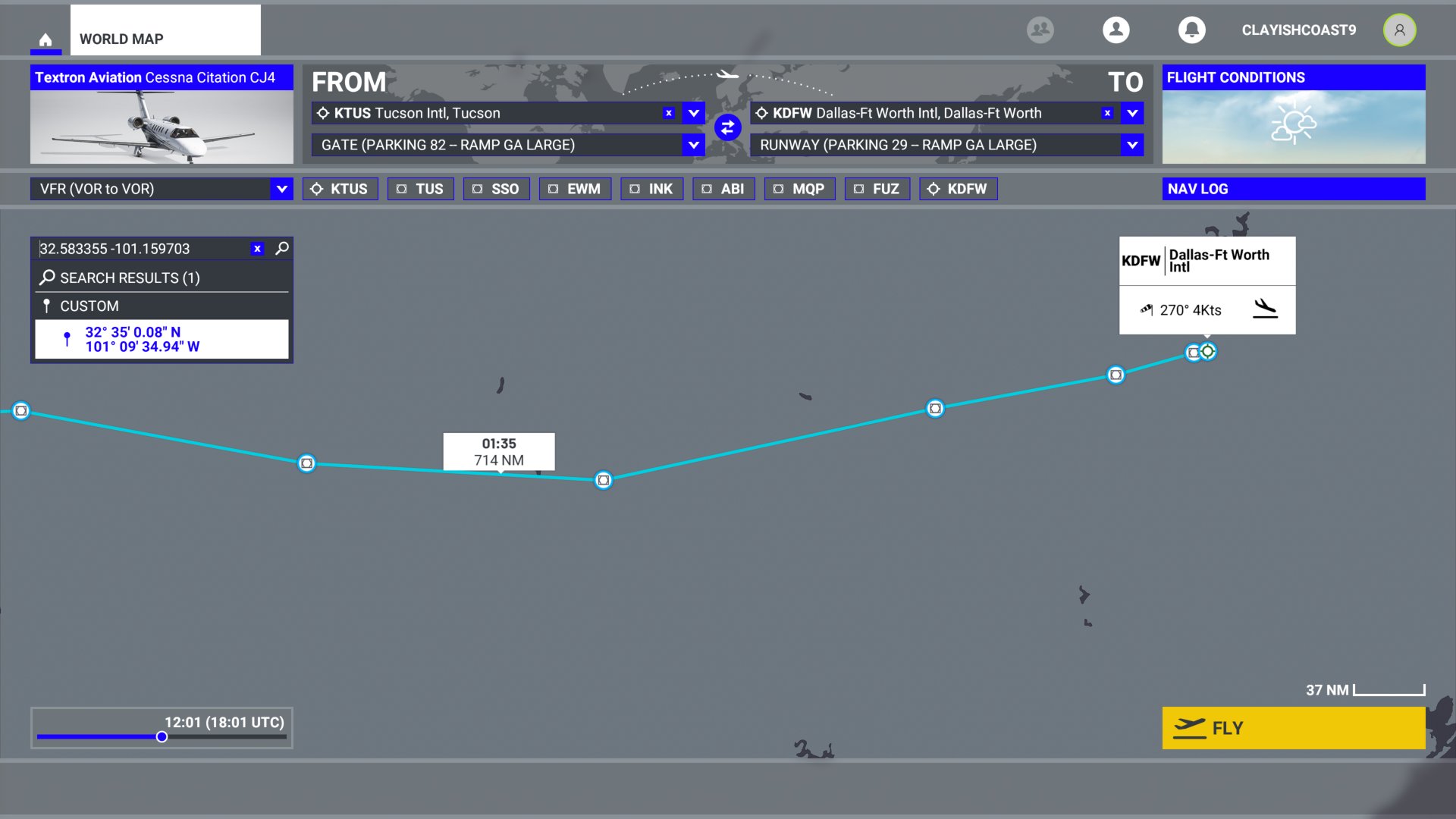
If you select another means of navigation - VOR-VOR, Low level or high-level airways, the flight path is automatically generated with the appropriate waypoints (VORs NDBs, intersection etc.) added. Here’s one I’m just making - Tucson to Dallas using VOR:

You can then customize this (although it’s not very friendly … hopefully it will be improved somewhere down the line). In this flight, I decided to go sightseeing at Lake J B Thomas - which is near the route - just for giggles. So, you can search for locations - limited to existing airport and navaids by name, or you can enter the latitude-longitude as I have done here (note - North & East positive, decimal values are standard - so if you find a location on Google maps, it will give you exactly the right numbers ![]() ):
):
If you enter lat-long and click on the search result, it will create a ‘custom’ waypoint:
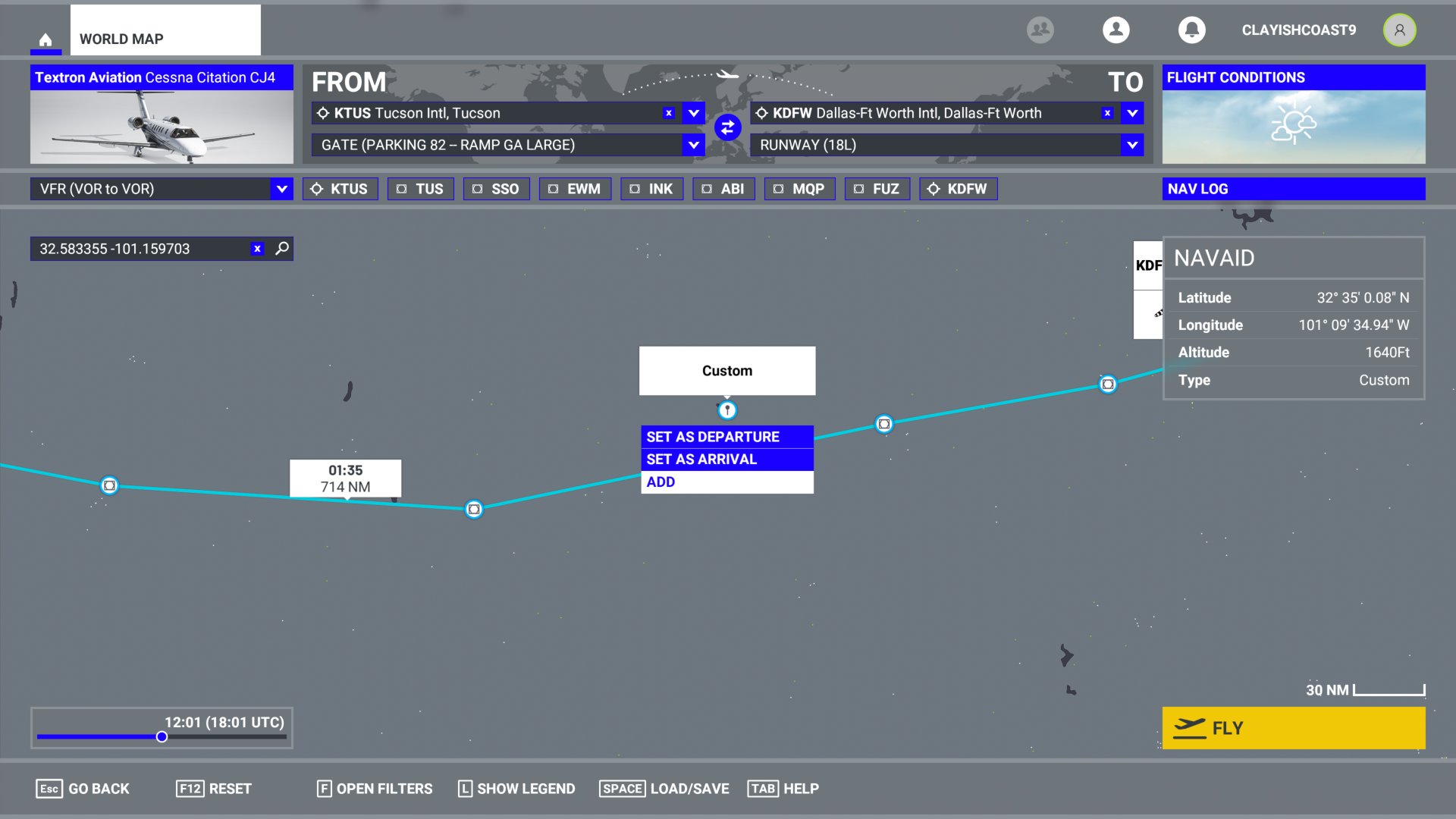
…Which you can ‘add’ to your flight plan.

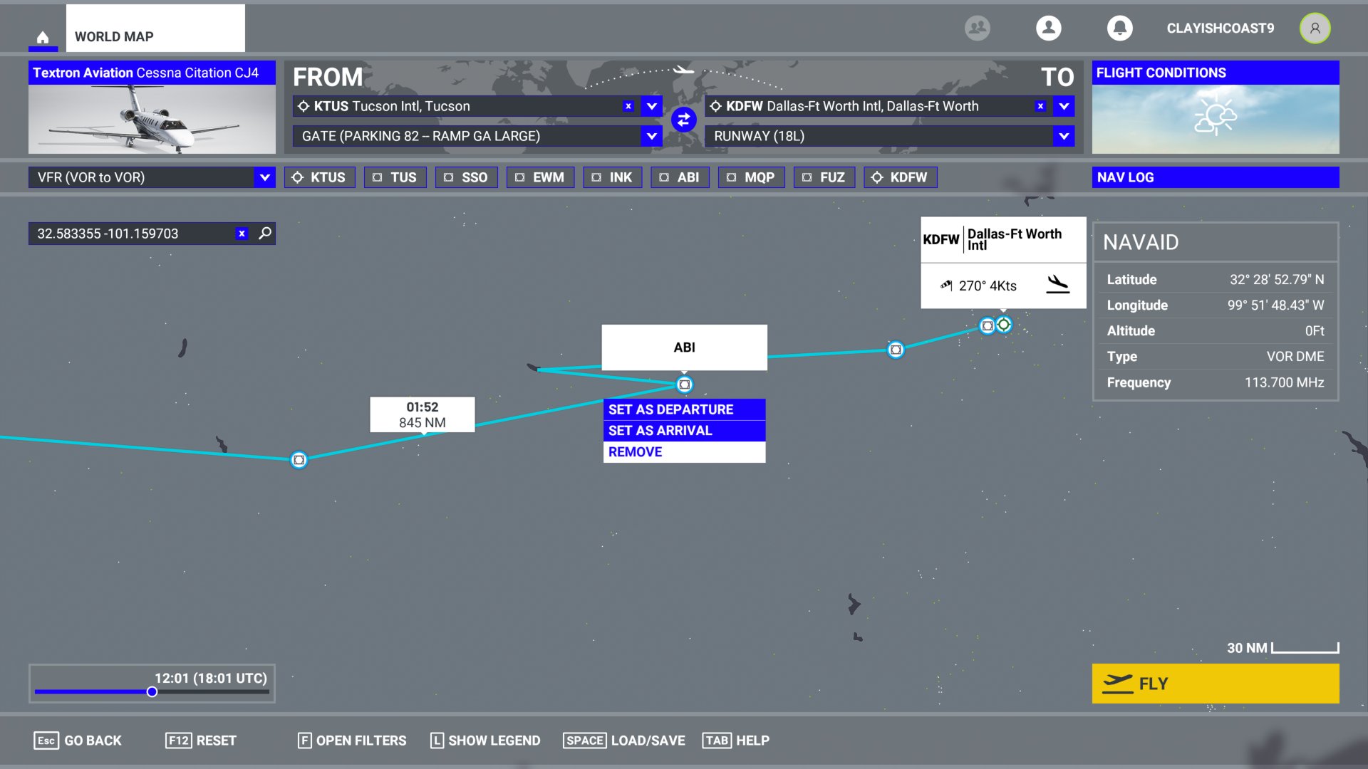
It doesn’t seem to insert it logically as you can see - in this case, I chose to delete the waypoint (ABI VOR) that looked like it should come after the custom point:
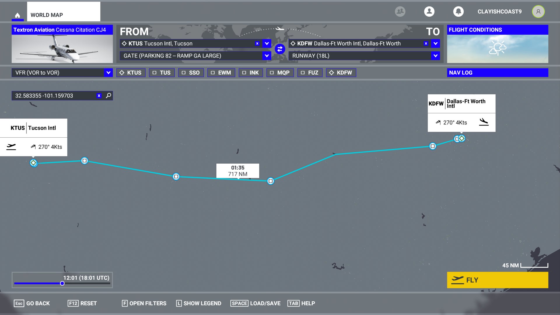
As far as I can see, there isn’t a a way to reorder the waypoints, or to rename custom waypoints (unfortunately) … it looks like that’s something you should be able to do in NAVLOG window but you can’t in the current version (or the altitude, or speed for individual points). This is the flight plan I made:
At the moment, that’s about the limit of what you can do within the sim. There are flight planning add ons that are much more functional, I don’t have much useful experience of those (but you can search the forums and find discussion on it)
Hope this helps! … Now off to fly it!
7 Likes
Thanks. This is kind of a mess while in flight though. The VFR map has so much ■■■■ all over it, I cant see any waypoints. Im looking around in the world and im not seeing any of my waypoints. Seems like this is really buggy right now. I basically cant figure out how to get to just a basic destination.
Actually I think whats happening is none of the overlay assists are working. Im supposed to be seeing a route and waypoint markers. I dont see them in the world or the map, and I know for a fact they are enabled in the options. Makes it impossible to get anywhere.
Ahhh see what you mean. TBH none of this is good at the moment, it sort of just about works at a minimal level. I haven’t seen quite what you’re describing. To me, it looks like the whole flight planning has been set up to have lots of functionality added, when they get round to it…
Just a sugesstion. You can load a VFR flight plan (*.pln) that you made on another editor (like Plan-G). It works fine
When setting waypoints what is the difference between vor and ifr? When I try to select vor to vor and go to fly, it doesnt show waypoints or a route on the map.
Hi Buddy
I would suggest you use Simbrief to plan your flights and load into FS2020. Navigraph is also a great tool. I’ve used both for years 10/10.
Tricky
Does this load waypoints into the game? I just cant get waypoints to work at all in the world or on the in game map and its really frustrating.
Hi Cygnus
SimBrief is where you plan your flight. It links with Navigraph (payware) to get the correct SIDS and STARS and Waypoints. When you have completed your flight plan you then download the plan to the default “downloads” directory where you can then load into FS2020. I would do your plan first before starting FS2020.
Tricky
Oh ok not really looking to pay more after already spending $60 on this. I guess ill just wait til they patch it and get these waypoints working. They only ever worked for me in training. In regular flights they dont work.
You can use simbrief for free - just need an account. Nav data is out of date; only need the subscription if you want to use the current nav data.
I only have limited experience with Simbrief - it is pretty comprehensive and detailed. It’s a great tool but a bit more ‘serious’ than I want most of the time! Haven’t tried using it with MSFS yet…
Im not looking for anything crazy. All i want is some ■■■■ nav points and a route lol. They just wont work in my game.
1 Like
Absolutelly donť understand why there isn´t option to show layer with Bing or Google maps to see where is what and by right click I cannot add custom waypoints, rename it and join this points to route by line. Is it so hard to implement? No, isn´t …
If you click on a leg, (the actual line on the map), it’ll highlight, and then you can add a waypoint to that leg.
I’m still trying to figure out if there’s a way to click the map to add a waypoint, without using the search box. I’m not entirely convinced there isn’t one. (Edit: Nevermind. I’m convinced.)
1 Like
I use vfr flight as planner. I noticed the best strategy is making the plan with fs 2020, save it, edit the file with any text editor and replace the points between departure and arrival with any list of waypoint you like from another planner.
PRESS F OPEN FILTERS.
Turn the last 2 option ON
Here we GO millions of waypoints to choose to make your own VOR to VOR Route…
And the best of it u get this route automatic into your Flightplan for Auto Pilot !
HAVE FUN
greetings
Neyaria
You used to be able to add waypoints just by clicking.
1 Like
I thought you could. It doesn’t let me add custom waypoints that way now though.
At least not once you have an arrival and destination set. I can still add airports, VORs, etc, but not customs.
1 Like
Same here.
1 Like