At what point in an ILS landing do you activate approach mode to have the AI land the plane ? How far out from the runway ? After the last waypoint ?
Im using the Diamond DA40 btw
At what point in an ILS landing do you activate approach mode to have the AI land the plane ? How far out from the runway ? After the last waypoint ?
Im using the Diamond DA40 btw
LOC or Localiser will align you horizontally with the runway.
APP will follow the glideslope of the runway and descend you vertically.
Once LOC is established then you can press APP. But it’s not that strict
When you are on the final (and proper) heading and altitude to intercept the LOC and GS. No use in activating it earlier.
In any case, not further away than 10NM from the airport.
It’s completely dependant upon the airport also looking at an approach chart usually gives you this information as well
No harm in turning it on a bit earlier. Do you have a reason to not enable it at more than 10 nm?
Yes of course. You are outside of the official coverage and hence the significant chance for incorrect capturing!
Thanks for the replies. One more question… at what point do you switch from GPS to LOC ? when you reach the first waypoint of the ILS approach ? Once the ATC clear you for the ILS landing ?
Oh and do you still need to deploy flaps manually ?
i dont. i just make a flightplan IFR in MS2020 and set the Appraoch there. Then start the flight:
G1000 to GPS Mode, Set my Alt and go
Press Autopilot, fly
then i look at the charts to get the height i have to fly on the approach point
then i go to ,lets say 2000 feet, when i am at the approach point i press appr. at tthe g1000. thats it, plane goes down and its a close to automatic landing.
flaps of course manual.
Hi @slackpanda1878. Welcome to the forums ![]() all good advice in the thread, but also worth checking the type of ILS at the airport you’re flying into. Not all ILSs are the same and not all of them are rated for a precision landing. definitely worth checking some charts if you dont want to end up on the grass.
all good advice in the thread, but also worth checking the type of ILS at the airport you’re flying into. Not all ILSs are the same and not all of them are rated for a precision landing. definitely worth checking some charts if you dont want to end up on the grass.
Happy flying ![]()
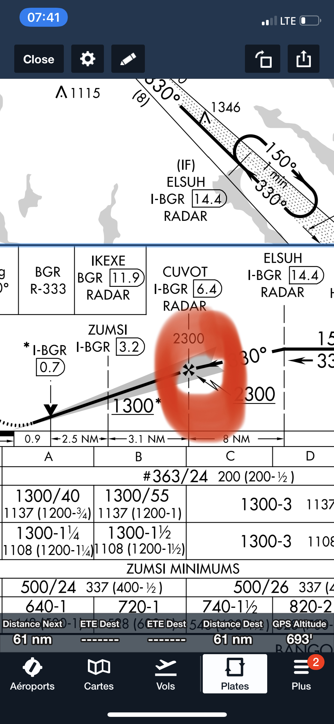
On the profile section of the approach chart, there is a cross that indicate the FAF (final approach fix). This is where the final approach segment start. If you are on an ILS approach you must switch to VLoc before the cross. The exact rule is that you should use the ILS to fly the final segment. GPS is ok prior to that point.
First, I’d ask for clarification on what you mean by “AI land the plane”. Because there is autopilot and then there is AI flying the plane. I think that when you say “AI land the plane” you do not mean enabling AI to fly the plane, and are asking about autopilot ILS landing. I am pretty sure that if you have AI fly the plane, it will flip switches as needed and fully control the aircraft.
For autopilot coupled landings, there is a published approach plate that shows the altitude you fly and a point X nm from the runway where you intercept glideslope. Ideally, you want to be in approach mode and be in landing configuration (flaps at landing and gear down and airpseed at 5kts above Vref) when you reach the GS intercept point.
A pilot is supposed to switch from GPS to LOC when one turns onto the ILS course. For straight in landings, where you approached the ILS course precisely from the exact heading of the course for say 50nm, I switch to LOC and APP mode when both LOC and GS diamonds are alive.
Thanks for all the replies, I’ve managed to do a few successful ILS landings now with approach mode.
I do have one issue though that once im in ILS range (ILAL appears next to the nav readout), if im a curved ILS approach and enable LOC it takes me off course… are you only meant to enable LOC1 when you are going in a straight line towards the runway ?
No. You push LOC or APP when you are on the intercept heading.
30deg is a standard intercept heading and also what you usually get from ATC IRL.
Some AP systems can intercept at and 100deg angle, but 30° works nicely for all systems.
At a 10NM distance the valid LOC coverage is +/-35deg. Further away this angle decreases to +/-10deg.
Noob question but how do you find out when you’re on the intercept heading ?
The LOC points straight out from the runway in a cone/funnel shape, so you need to at least be lined up with the runway.
Use skyvector.com or something similar to find your ILS approach charts. It will have the LOC radio frequency and the course heading for you to plug into your autopilot. It will also show the altitude you need to be at to intersect the glide slope. Handy stuff. I use FltPlan Go on my cell phone, for this, since it has Canadian airports.
The intercept heading is the heading which leads you towards the localizer.
Once you are on this heading, there will be no more heading change until you intercept the localizer.