I’m not sure if this is the right section in the forums for this but I wrap my head about a question I wasn’t able to solve thus far.
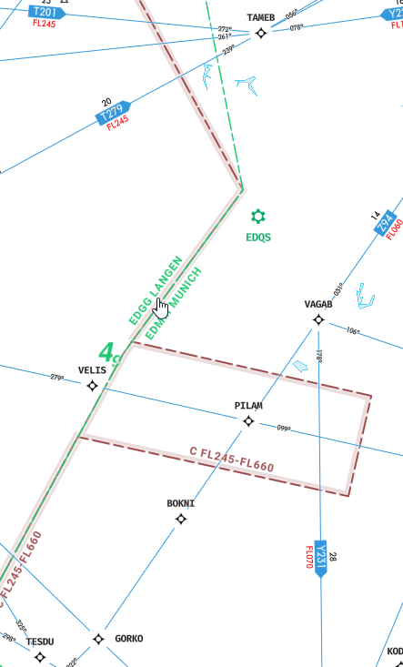
I want to setup my com inbthe simulator manually. So I know there’s different ATC control zones in Germany for example. There’s Langen, Frankfurt, Bremen and Berlin. So far so good. But how do I know when exactly to change frequencies when on VFR? I mean how do you real pilots know it? Is there like a map for it? Because I couldn’t find one.
You mean in the simulator? I admit I havent digged in very deep into the pre flight map filters and the Garmin one shows a lot of blue and grey lines and magenta. Beautiful colors but I couldn’t exactly figure out yet how to read them.
Do you think there would ever be an add-on or app for a phone in which I could track my flight in the simulator in Xbox? Is the technology in Xbox even there? It is this something that will never happen? Is the possibility there for a developer?
Edit: ok. After some searching it seems simmconnect for Xbox is on a wishlist. Weather ever happens or not beyond me.
Could you buy a paper chart? I have two paper VFR charts for the LA area (LA sectional and LA terminal area chart). They weren’t that expensive and I bought them online. I use them when flying on PilotEdge. I suppose you can’t do PilotEdge on Xbox, but you can still fly with reference to the charts to be aware of which airspace you’re in and which frequencies you should be tuning. It could get expensive to buy enough charts for large areas, but if you restrict your flying to a relatively small area it might be an option?
I fly only EDFM-ESMS and back because it’s closest to my frequent real life passenger route EDDF-EKCH. But with the tbm 930 I don’t want to use big airports and Mannheim is closest to my home town. I have the Airspace charts of the airports. EDFM is really interesting with a non ILS loc. for both runways, circle to land right traffic only and one of the most challenging approaches in Germany. One must even certificate for it and renew it every 2 years I learned.
Apart from that I actually do some island hopping. I tried a trip around the world in the tbm 2 years ago but crashed my plane into Greenland which I miraculously survived. I ended up eating my co-pilot and lost a few toes from freezing. Next time I’ll be prepared better
If only I could use my Coms propperly. Ty for the advise. I’m digging into some apps that might be promising. I’m not sure if I want to pay for a subscription at Navigraph. But that’s my best bet momentarily to get my hands on charts.