Hello everyone!
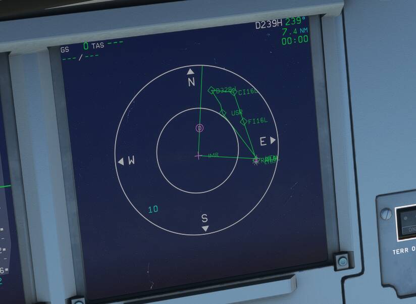
First of all I didn’t know where to put this topic so I thought here is the best place to get your advices. I am also navigraph subscriber. My issue is for some specific airports and for some specific runways, the waypoints seem to be incorrect. I read that this is not navigraph related issue, but I still want to ask you good people whether there is any workaround for that ? For the clarification I will add a picture below. I use simbrief for importing the flight plan into my FlyByWire A320 but if I use the msfs’s route suggestion for the IFR it won’t change anything. So here is the waypoints.
I try to remove IMR waypoint but the MCDU won’t let me do that. Even I was able to remove it USR and one more waypoint seem to be additional for the approach. Is there anything I can do to prevent this ?
Thank you so much for all your comments and helps ! 
2 Likes
There are STARs and there are Approaches.
Procedures are followed until ATC starts giving vectors / instructions.
Which procedure is incorrect?
all MCDU’s/FMC are beta and broken
1 Like
Can you tell us which approach is this? I’m reading your post letter by letter and analysing the screenshot you provided, but I can’t tell which approach to which airport is this.
Thanks a lot for the answers ! Sorry for not being clear since I don’t have the knowledge of the terminology. Approach is to runway 16L to LTBJ via BERG1C to be more specific.
It’s broken. Funny even online you will run into issues. Had LAX Center ask if I was having issues on the RNAV approach into 25L. Hey I’m just flying what the MCDU spit out. Flew into SEA once and just flew DIRECT after passing HAWKZ to hit all my waypoints. For example the SONOR waypoint doesn’t exists when plugging in the HAWKZ 7 arrival into the MCDU.
I just checked the charts for this arrival and it looks correct.
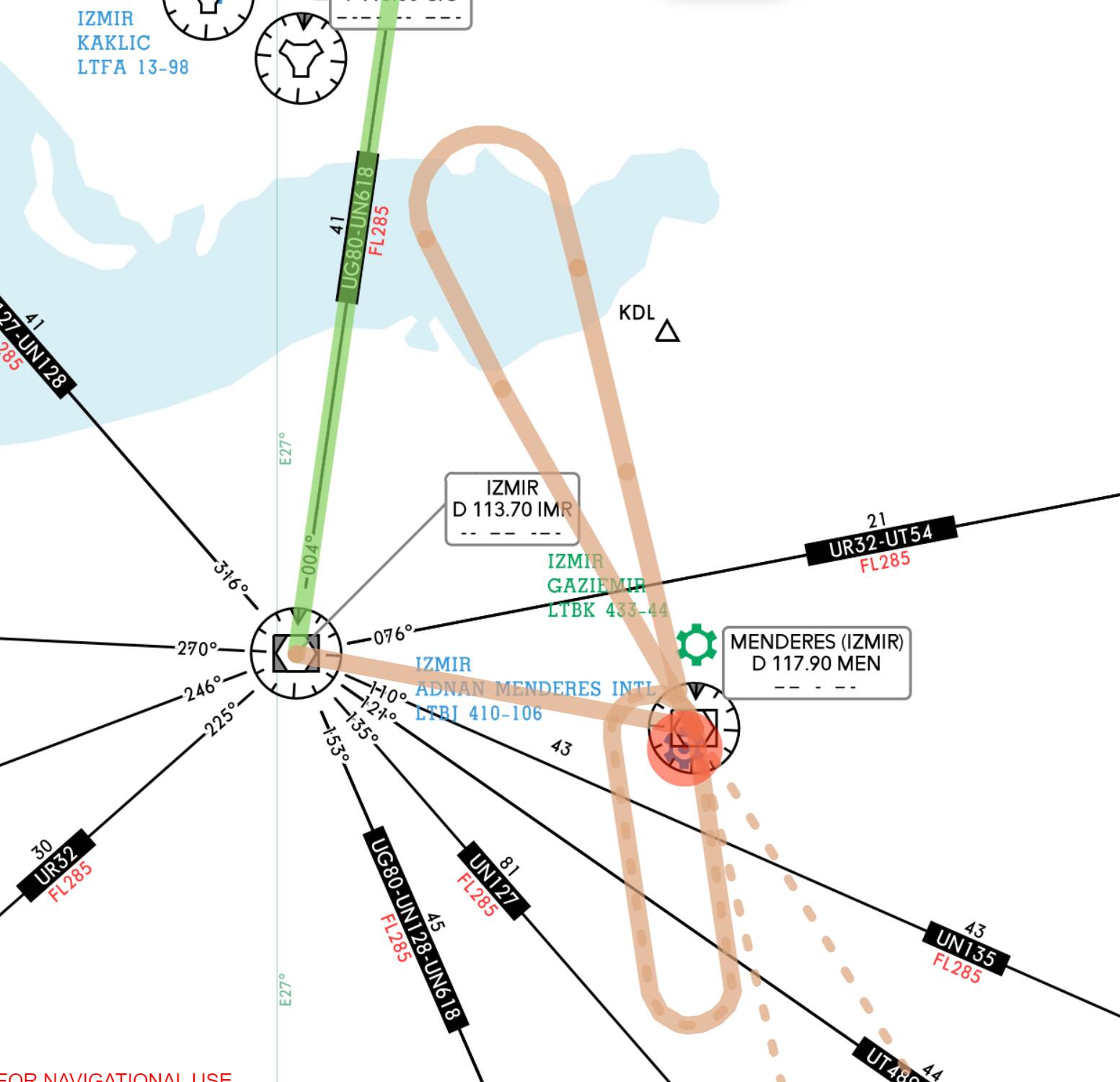
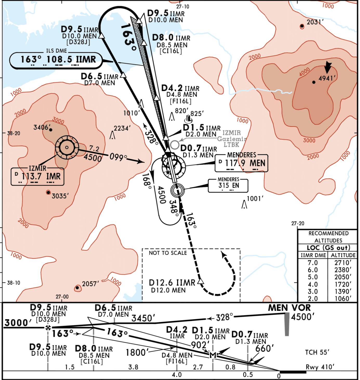
The BERGO1C is leading you from BERGO directly to IMR.
The ILS Approach then is going from IMR to MEN and on 328 degrees 9.5 miles out and from there in a right turn onto the ILS.
Looks exactly like on your ND.
1 Like
Thanks for the extra information. I just looked at the navigraph charts for the ILS 16L approach via BERG1C, and even navigraph plots the same approach as what you’re seeing in your screenshot.
So the transition waypoint is VIA IMR, then fly straight to MEN, then do a turn north to D9.5 and then right turn down south to intercept the ILS. It looks the same as your screenshot. I’m not sure what the issue is here.
1 Like
Also for what it’s worth not all approaches are broken or missing waypoints or injected with fake ones that don’t actually exists. The major issue is you cannot delete waypoints in SIDs/STARs in my opinion
3 Likes
Yeah, that’s true.. which is why I always have to choose the right SID and STAR the first time.
This is really annoying. However WT managed to get rid of the problem in the CJ4. There you are able to modify STARs and delete waypoints.
In the Aerosoft CRJ it works perfectly as well, but of course this is not a default plane.
5 Likes
Thank you so much for the detailed answers. Maybe my interpretation was incorrect. You are absolutely right that my ND shows the correct waypoints. But when I follow these waypoints the approach does not make any sense.
So please correct me if what I understood is correct. The waypoints are all correct but normally ATC should give me vectors right during the approach? I mean since I fly offline mostly, I follow the waypoints until started descending by using APPR button on final. Again apologizes I may not be using correct terminology here since I play the MSFS just for hobby.
Thank you so much again !
Currently the default ATC in the sim doesn’t give you vectors. They just assign you the approach so that you enter the approach into the MCDU, and have the aircraft follow it.
So even if you put all the STAR and Approach into the flight planning tool in the beginning. The ATC is just “clearing” you to proceed with the approach. It doesn’t give you anything else other than that.
Can you elaborate on this? Are you experiencing where the Aircraft AP doesn’t follow the path to each of these waypoints and just skips them to head towards the runway directly without passing through these waypoints?
1 Like
I try to be more specific So imagine if I follow the waypoints first go to IMR then to MEN then I will have to turn north to D 9.5 over the airport as you described. But whenever I check the airplanes from flightradar it seems like they directly go to D9.5 from BERGO. If I follow what I have in the MCDU I don’t even think that the aircraft will be able to perform a turn to D9.5 then another U turn to the airport on final. I’m not sure if I can describe it well but hope it is kind of clearer now ?
The logic behind the planes computer is broken. You’re not doing anything wrong. I opened a thread yesterday about the exact same issue because I was so confused. Here is another example if anyone needs to see the problem again. HYDRR1 into KPHX.
https://forums.flightsimulator.com/t/need-help-loading-arrival-into-airbus-mcdu/387953
4 Likes
Thank you so much that describes it pretty well I guess That is also what I do. I don’t select no VIAs but it still will enter the IMR to the flight route
Taking a quick look at the plates for your chosen approach the first thing that stands out to me is the terrain. I expect the reason the approach waypoints don’t seam to makes sense to you is that the approach is designed for terrain avoidance utilizing the available radio aids. This layout allows you to descend to approach height while heading out over water. Pretty standard.
There are plenty of approaches that may seem counter intuitive. If you take a long look you will see that this approach loosely follows a standard right hand circuit. Pass over the airport, proceed north of the approach and right turn to final. If you fly mountainous terrain enough approaches like this become ‘old hat’. Most of these cases will not involve radar vectors as radar is unreliable within mountainous terrain. Follow the waypoints and nail the headings and even a non-AP hand flown approach is safe.
2 Likes
Thank you so much again ! To me when I follow the waypoints but when I see something different in real world approaches then I have the feeling that I am doin something wrong 
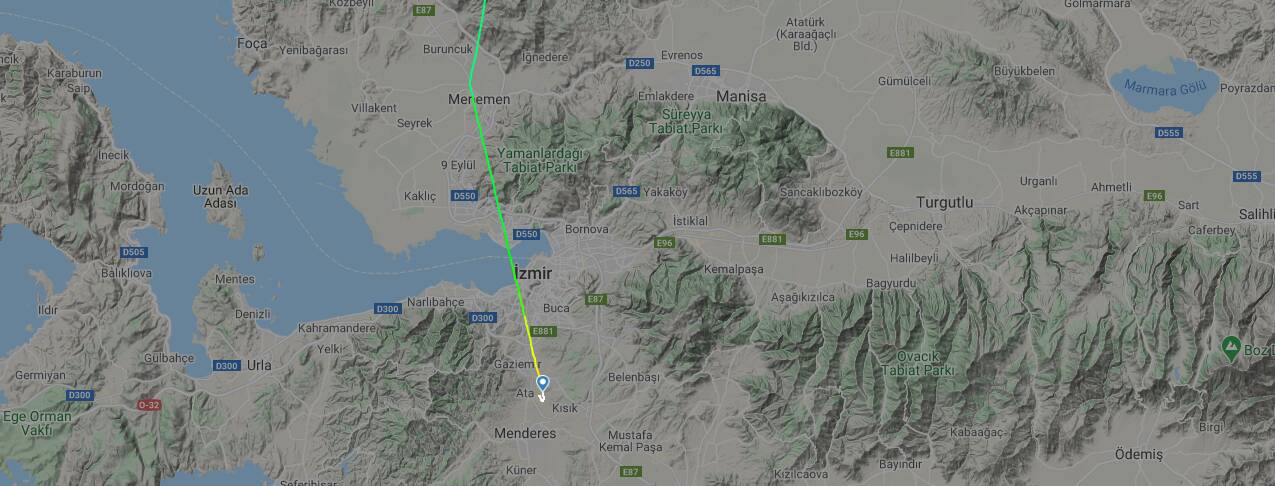
For example below image was taken from flightradar assuming BERG1C approach but went straight into the airport.
Then this real life aircraft just doesn’t follow the BERG1C STAR. and probably vectored in by the ATC to direct to final. It’s still your choice. Looking at the available BERG1C STAR, the waypoints presented both in the MCDU and in the Jeppesen charts. They’re correct. So if you want to fly the whole arrival pattern and approach. You’ll be correct.
But if you want to skip the STAR and direct to finals down to the runway, as long as it’s safe to do so, and it’s your choice. You can do it too.
I don’t see anything wrong in either case here. Plus you have evidence real world evidence. to support the direct alternative.
2 Likes
I try to be more specific So imagine if I follow the waypoints first go to IMR then to MEN then I will have to turn north to D 9.5 over the airport as you described. But whenever I check the airplanes from flightradar it seems like they directly go to D9.5 from BERGO.
Well, yes, if there’s active ATC, and it’s not busy in the skies, real ATC will often clear an aircraft straight into the ILS. This is not something the Sim ATC will do. You’ll follow the complete procedure.
If I follow what I have in the MCDU I don’t even think that the aircraft will be able to perform a turn to D9.5 then another U turn to the airport on final. I’m not sure if I can describe it well but hope it is kind of clearer now ?
Of course your plane won’t be able to ‘turn on a dime’, the autopilot should initiate the turn a bit sooner, so that it will stay more or less on track. The sim’s AP might lack here a bit. You can emulate this yourself by switching to Heading mode, and follow the vectors from the chart (so in this case, from overhead the airport head on to a heading of 328 degrees, until you’re at a distance of 9.5 Nm from IIMR, then make a right turn to 163 degrees, which should align you with the ILS).
While it might look convoluted at first, you’re dodging the two mountains east and west of the airport (3400ft and 4940 ft tall respectively).
These are the IFR approaches, so they can be followed in zero visibility.
3 Likes