Why do we need major scenery updates that are multi-gigabyte downloads taking hours and hours if we “must” (I have been left to believe that this is a hard requirement) use on-line scenery anyway?
Why not just update the scenery servers and save everyone a six+ hour download per world scenery update?
At minimum, the hand crafted airports and POIs are 3D models and textures that wouldn’t be included in streaming PG data need to be stored locally. In fact, they are meant to overwrite any streamed data, so those files need to exist somewhere.
Why they can’t be streamed via a separate system might be a matter of limiting complexity. If you’re streaming PG data and then trying to stream, from an alternate source, custom 3D data and textures, synchronizing them so that happens seamlessly would be, well, difficult.
I think having them on the local drive removes that potential bottleneck/synchronization issue.
For comparison, the “City Update 1” photogrammetry update for Germany was like a megabyte – it contained only photogrammetry updates, meaning it only listed the areas to stream from the internet; all the PG data really is on the servers.
The 3d-modeled POIs and airports, however, will still be available for offline play.
IMHO it’d be nice if they could separate out the “3d modeling & textures” from the “nav data” and stream those things too, but that’s just not how it works.
So you get a World Update update that includes all the POIs and airports (several gigs), and a reference to the online PG data (a few kilobytes).
IMHO, one thing I would like to see as an available option is all the data available as a download, perhaps as (s)ftp, or a torrent, or whatever so people with storage can have the entire enchilada local, with a periodic rsync to keep it up to date.
If you want the whole shebang, it’s there. If you want it streamed, you can have that too.
This has been brought up before, and don’t recall the numbers, but the storage capacity it would take to do that is outside of the realm of realistic for any of us.
Would it be rude of me to ask exactly WHERE all this data comes from as it seems, in many cases, that the terrain data and photometric data is quite old - or just blatantly wrong.
I totally understand that we don’t have a dedicated constellation of near-earth satellites just to give us current data, (), but ten year old data that’s missing major landmarks? (shaking head in wonder)
Correct me if I’m wrong but wasn’t the whole idea of photometric data and a MONSTER system to enable the sim to finally get the scenery and terrain RIGHT ?
And you will notice I referenced it in the original post. (laughing!)
Google and Yandex get it from somewhere, and they’re pretty close on, (plus-or-minus a few years). And I’m not talking about Google driving around getting street imagery.
Microsoft has at least as deep pockets as Google; they should be able to stream similarly accurate data.
I was referring to, literally, they are right now talking about satellite imagery and where Bing gets theirs. Someone even showed a screenshot of Bing’s Toronto to show how much better it looked than the WU version.
Updated Photogrammetry is an expensive and labor/time-intensive effort. Hence you won’t see it refreshed as often as satellite data is - which the latter is used for Bing Maps Streaming.
Note though, Bing Maps and what is streamed on the sim is not identical. They are separate datasets - notably, there has to be corrections made for color and other optimizations since it’s being viewed at closer distances than just browsing for addresses on the web page. So there will be a gap in continuity and currency between the two.
Add to that, Autogen is generated by BlackShark.ai and informed in part by geographical location (i.e., building types that go down to regional styles) and height information provided by Open Street Map, which is not an MS-Asobo product.
Finally, currency of overhead satellite and topography is limited by access in part based upon information that is willingly released to Open Source or Commercial Markets by individual nation-states. Some will not willingly release even slightly current or detailed satellite imagery or even Photogrammetry of their territory to the open public.
These are all challenges to storing and even syncing the data locally.
I saw that too. I’m watching that thread and I’ve put my two centavos in about how horrid the data is in some places as well.
I live just outside of Moscow and flying around here would be hysterical, if it weren’t so tragically wrong.
Example:
If you fly over Moscow, you will see a relatively tall pointy building that will be marked as “Moscow State University” - and that’s absolutely correct. That building dates back to the time of Josef Stalin, and there are supposed to be SEVEN of them - the “seven tall buildings” in Moscow. In fact, up until ten years ago or thereabouts, it was illegal to have a building taller than them.
I figured that was a part of the problem as [certain redacted intelligence agencies] are not as forthcoming with their data as we’d like.
But there’s really gotta be a better way.
Absent creating a separate thread, (which I may do), part of the problem is that, (IMHO), Microsoft may have bitten off more than it can chew - advertising world class scenery and aircraft models that are second to none, (etc.) In a fictional game-world all that’s required of the scenery is that it be believable. If flying next to a Zorgon Force Generator causes your space-craft, (that you fly like an aircraft anyway), to suddenly wing-stall to the left - that’s not a bug, it’s a feature!
However MS/Asobo is trying to model the real world that contains real places and real aircraft that real people have flown - and the tolerance for error is correspondingly small because people are very sensitive to errors in their surroundings.
The challenge with big datasets is the classic curve - the majority of your data is in the middle, very reliable, integrity checked and fit for purpose. At the edges of the curve are the areas of the world where observation is not possible, democratization of data (not the political term) is absent, and integrity checking is nigh. In short - best guess based on available information.
It’s a living world. Change is inevitable in it, and until someone can engineer a better way to update the data in real-time, this is an impressive marriage of Big Data, Cloud Services and the transformation of discrete types of services originally designed for a different purpose successfully into a credible simulation.
First of all, I really appreciate the commentary and I am hoping others can read this to gain an understanding of the magnitude of the issues involved.
The question of the “simulation” being “credible” is exactly what the Canadians are arguing aboutdiscussing in their thread, (referenced in the first post).
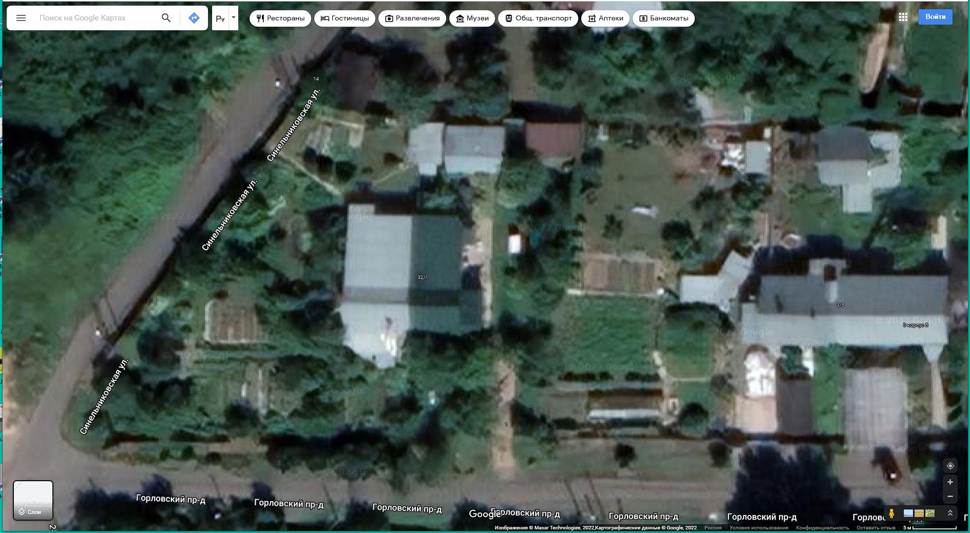
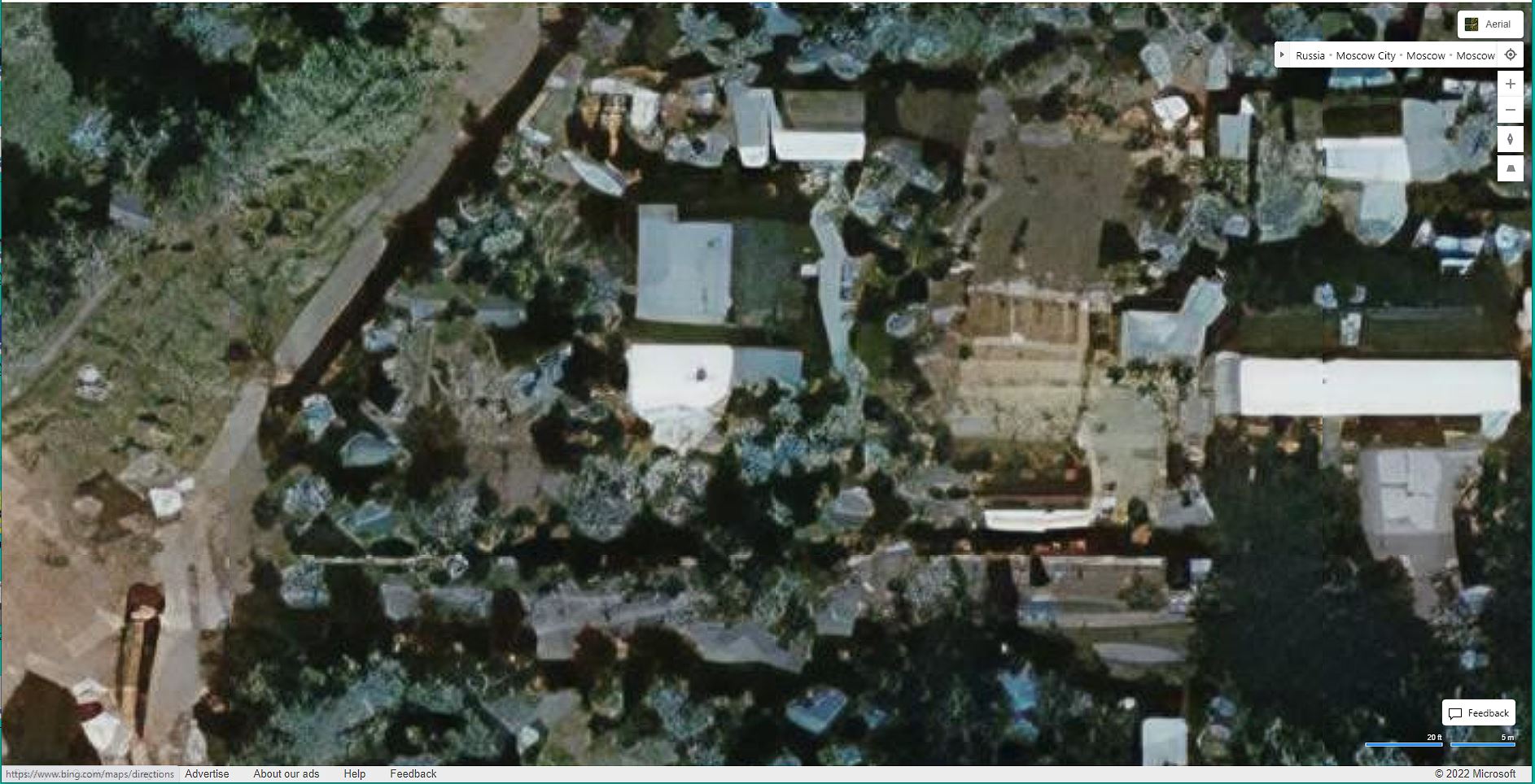
Here are three pictures of “my house” in Butovo, just south of the MCAD. (North is up.)
This one is by Yandex - they actually have a high resolution close-up image.
You can see that things are substantially similar except for the resolution.
You will notice that the car is not there and the small white rectangle just to the right of the green roof is my wife’s lawn swing.
Gorlovsky Proyezd - the road in front of our house - is curved all around. In some places, it’s not even visible though it should be clearly visible - except maybe at night - and even then there are street-lights.
It looks like we have a small road or a long paved driveway right next to the house. Again, all curved around.
The thing that looks like a brown snake in the far lower left is construction where they were digging up the street to install gas mains. That was about seven-or-so years ago.
You will notice considerable visual artifacts - as if the picture is a composite of several pictures, taken at different times of day and from different angles - all stitched together.
This is exactly what people are discussing in the Canadian forum and in other discussions all over the web - the Bing imagery is horrid and bears very little resemblance to reality.
This is one of the main reasons I asked about local storage of images - perhaps starting with a good map, correctly oriented with respect to everything else, (that’s the tough part!), with the correct scenery overlays, you’d have a pretty neat setup.
I found out last month that Bing uses the exact same imagery as Google Maps ( if they actually update the maps in the first place since Bing has extremely outdated imagery)
Last month Bing updated the imagery of my city (finally after being 4 years out of date) and I realised it’s the same exact imagery that Google Maps had in April of last year
Then why does Bing’s imagery vacuum so thoroughly? None of these services use their own images, (except maybe for Google Street View) - they all use 3rd party imaging sources.
It makes no sense to me why, on something that’s supposed to be one of their flagship products with enough hype to launch a moon rocket, why they would use such totally garbage baseline data for their scenery? If someone could please explain it to me, I’d really appreciate. And yes, imagery isn’t free - but if they’re pulling imagery from the same sources Google uses, why not get stuff that’s only slightly dusty instead of fossilized data?