Also when I fly the sim in Europe and request to cancel flight following MSFS ATC actually tells me to squawk 7000, so it would be nice to be able to push the VFR button to set it.
1 Like
I wonder why I have not seen that. I have used the keyboard to enter waypoints PLAZA and WOPOD dozens of times and never had the P cause an active pause. Does the keyboard icon next to the text input remain blue as you are typing the P? I use lock mode and the Windows on-screen keyboard for waypoint text entry, maybe that’s why I do not see that issue?
I want the NXi to operate as it does in real life. If you can configure VFR button it in RL to be 1200 or 7000, then hopefully we get it. If you can’t, then we shouldn’t.
The VFR code is not a pilot adjustable option and can only be changed by a Garmin installer through a flash. So presently, this works as in IRL.
2 Likes
This seems like the perfect situation where making allowances to the fact that this is a simulator should override the desire for perfect realism.
1 Like
I haven’t checked this exhaustively, but it seems to me that the sim appears to know where your flight starts and sets the appropriate code internally. By default, when I hit the XPDR softkey, over the resulting VFR softkey I recall only seeing 1200 when flying in the US and 7000 when flying in Europe. I’ll have to check further when flying tonight.
If this is indeed the case, this looks to me like no further action is needed. The “Garmin installer” guy would then seem to be embedded in the sim.
Hello all,
Please don´t consider this complaining or nagging, just genuine curiosity:
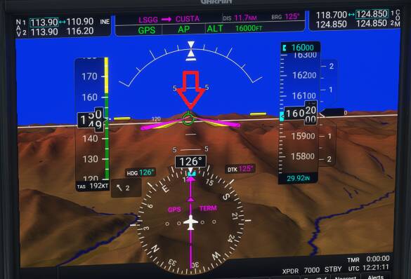
I noticed that the white “horizon” line across the G1000 NXi´s PFD in the sim behaves like a visual horizon would appear, as opposed to a zero-pitch line.
I´m not a pilot, just an aviation (and sim) enthusiast, but my understanding of real-world synthetic vision systems is that that line should (roughly) indicate terrain clearance. i. e. it should appear above terrain that is under the plane and vice-versa. (see for example this FAA document (paragraph 7))
Flying towards Montblanc, at a distance from about 12 nm (and slightly above the highest point), notice that the line crosses the peak indicated by the red arrow):
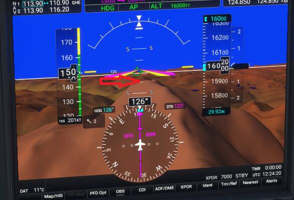
When closer it “moves” like visual horizon would do if you are above the peak:
So my questions to pilots and developers:
- Does the real world unit´s white line behave like a horizon or as a zero-pitch line?
- If the sim´s implementation is different from the real unit, are you planning to introduce this feature (I understand that access to terrain data is difficult at the moment through the SDK)?
Thanks for the outstanding work!
1 Like
the white ‘line’ is your ‘selected’ elevation height as indicated, and also your ‘zero’ pitch line, AOA is the green circle, and the numerical lines in the blue indicate an up AOA and below a down AOA, Mt Blac elevation is 15,777 ft and your just above
1 Like
Interesting results. Spawning in Europe or the US results in the appropriate VFR code showing on the PFD. However, choosing XPDR produces different results. In the US, a green light segment shows over the VFR softkey. Entering another code then choosing VFR returns 1200. In Europe, 7000 initially shows as the active code. Choosing XPDR shows no green light over the VFR softkey. Switching to another code and then choosing the VFR softkey returns 1200.
So, things work what I’d call correctly in Europe as long as you don’t switch away from 7000. Anywhere, choosing the VFR softkey returns 1200. But so as long as you don’t change codes, you should have the correct VFR code for your location.
2 Likes
“… terrain above the aircraft’s altitude should appear above the zero pitch line, and conversely, terrain below the aircraft’s altitude should appear below the zero pitch line. Displays using a flight-path-marker should be designed so that when the flight-path-marker appears above the terrain, the airplane will clear the terrain and vice versa.”
This is quoted from the FAA advisory circular he linked in his post. The screenshots he provided make it pretty clear that the synthetic vision display does not meet those requirements.
The green circle doesn’t show AOA; it’s the flight path marker or velocity vector. It shows the direction the aircraft is going. Therefore, as the AC specifies, if the aircraft is at an altitude higher than the terrain, the flight path marker should be displayed above the terrain. In the screenshot, that clearly is not the case. The flight path marker makes it seem like his aircraft will hit the side of the mountain.
@cgbFlight Really clever observation you’ve made. You’ve got me interested now as well. I wonder if it is something that can be easily fixed. This video seems to support what you’ve said. The zero pitch line is supposed to be positioned such that it is an indicator of terrain clearance. https://youtu.be/NnvFvGuJ4wM?t=102
1 Like
So, this is more of a geometry issue than an issue of accessing the terrain data. The line doesn’t move up or down based on surrounding terrain, instead it’s just the line at which the plane is at zero degrees pitch relative to the earth. Terrain data is not required to make this accurate.
We actually spent a good deal of dev time messing with what was going on here and trying to figure out exactly why the result is sometimes not as expected. The line actually does represent 0 degrees of pitch properly, in the sense that when the attitude indicator and flight path marker are on the line they do properly indicate that the plane is at 0 degrees of pitch and/or AoA. However, the sim’s SVT camera projection presently makes it such that the horizon is also mostly coincident with the center. Since we cannot influence this projection at this time as the entire graphic is shipped to us from the sim this is as close as it can be.
We may investigate ways to improve this API in future sim updates such that the projection can be parameterized for more varied screen ratios and attitude indicator positions, as well as make the switch between a horizon centered projection and a static inclination (zero pitch) projection.
4 Likes
This is because these are distant and unrelated systems and processes within the sim. The sim internally sets the transponder code when generating a new game flight through the game flight generation logic, but there is not a way to query the sim for what local VFR squawk would be for the present position from the avionics.
2 Likes
Where can I download this Garmin installer of which thee speaketh? ![]()
Maybe you could add a configuration page to it with sim related options, like the one in the CJ4?
Having a Garmin installer come by my home for this seems excessive. ![]()
4 Likes
Thank you @Bishop398 , much appreciated!
Sadly no easy fix, as Bishop398 comments.
This is referring to the unit in a real aircraft (=IRL), not the sim.
Well, that’s a shame but I think there may be some chance it does happen later down the line. Fingers crossed.
But to be honest, it’s normally not something that drastically affects a flight. There are other ways of ensuring terrain clearance.
The simplest way to ensure terrain clearance is MEA on IFR, MEF on VFR. Worst comes to worst, if you have SVT, look at the FPM. If it intersects with terrain, yes, you are going to collide unless you do something.
Also keep in mind, that the Garmin manual specifically has these Warnings concerning terrain clearances.
"WARNING: Navigation and terrain separation must NOT be predicated upon the use of the terrain avoidance feature. The terrain avoidance feature is NOT intended to be used as a primary reference for terrain avoidance and does not relieve the pilot from the responsibility of being aware of surroundings during flight. The terrain avoidance feature is only to be used as an aid for terrain avoidance. Terrain data is obtained from third party sources. Garmin is not able to independently verify the accuracy of the terrain data.
WARNING: The displayed minimum safe altitudes (MSAs) are only advisory in nature and should not be relied upon as the sole source of obstacle and terrain avoidance information. Always refer to current aeronautical charts for appropriate minimum clearance altitudes."
Regards