I have just uploaded @Djeez2 's video to YouTube which should be easier to access. I hope he does not mind, I am just trying to help. It is a decent video that clearly explains his issues.

I have just uploaded @Djeez2 's video to YouTube which should be easier to access. I hope he does not mind, I am just trying to help. It is a decent video that clearly explains his issues.
Thanks, I don’t mind. I wonder why some people can see it and some can’t.
Tried the latest version today on approach to Kerry EIKY. The glide slope handling is much better now, no drift at all, it was really solid and handled wind and turbulence well.
Thats odd, yet again - i did two flights today, both great but the 2nd one was windy, the system lost the slope by about 2-3 dots under the slope at one point and 2 dots over at another, it did land me ok though so i counted it as a great success as it just didn’t work well before
Did it adjust though and correct itself automatically when it drifted or did you have to make changes to the throttle RPM to get it back on track?
This is on the latest, 0.12.2? (which you can confirm by checking the version number on the MFD boot screen)
Yes it corrected mostly but i was a bit low on the runway end, i recall this might have been like that before though
Yes on the latest update, installed this morning
is broken yet?
That used to confuse me quite a bit.
Even if you don’t use vertical nav or autopilot, Vectors can help with runway awareness when approaching an unfamiliar airport. If you want to do a visual pattern it can help with manually entering the pattern.
Straight behaves the opposite of what you would think as straight. It will put you on a pattern to intercept the final given your approach. It’s kind of like doing an IFR pattern. This is basically full on autopilot.
If you are flying in to a towered airport, you can at about any point do a Direct To activation on the final. If you are down wind it will ofen line you up and the tower will clear you on a straight approach.
I’m not sure what the real world use of doing a Straight Visual Approach procedure would be. I can see a few of the real pilots on here having strong arguments against using it with a fight following. It’s not an airport procedure, and if there is a tower they’d probably ask “WTH are you doing?”
Visual Approach is useful to uncontrolled fields that the pilot is unfamiliar with. You can still fly the circuit (as one should) to orient and check for obstructions, but the you can activate VA to get an optimal separation and GP.
It’s very tempting in the sim to take the nice tight pattern it creates on AP. It will do a teardrop approach if you come in down wind.
That’s why I wonder what the practical use is in real flying. Like with a tower, could you request that approach?
I used to work in avaititon and I remember when new airplanes were being delivered the pilots used to make grand entrances, buzz the tower, etc. for the delivery and photo ops.
You’re not really intended to overfly the field. That happens when the approach is only loaded, and the Garmins put the destination airfield before the approach segment. Instead, you would activate the approach (which would put you direct to the straight fix) when you’re in a good position to do so, perhaps even after using heading mode for a bit if necessary.
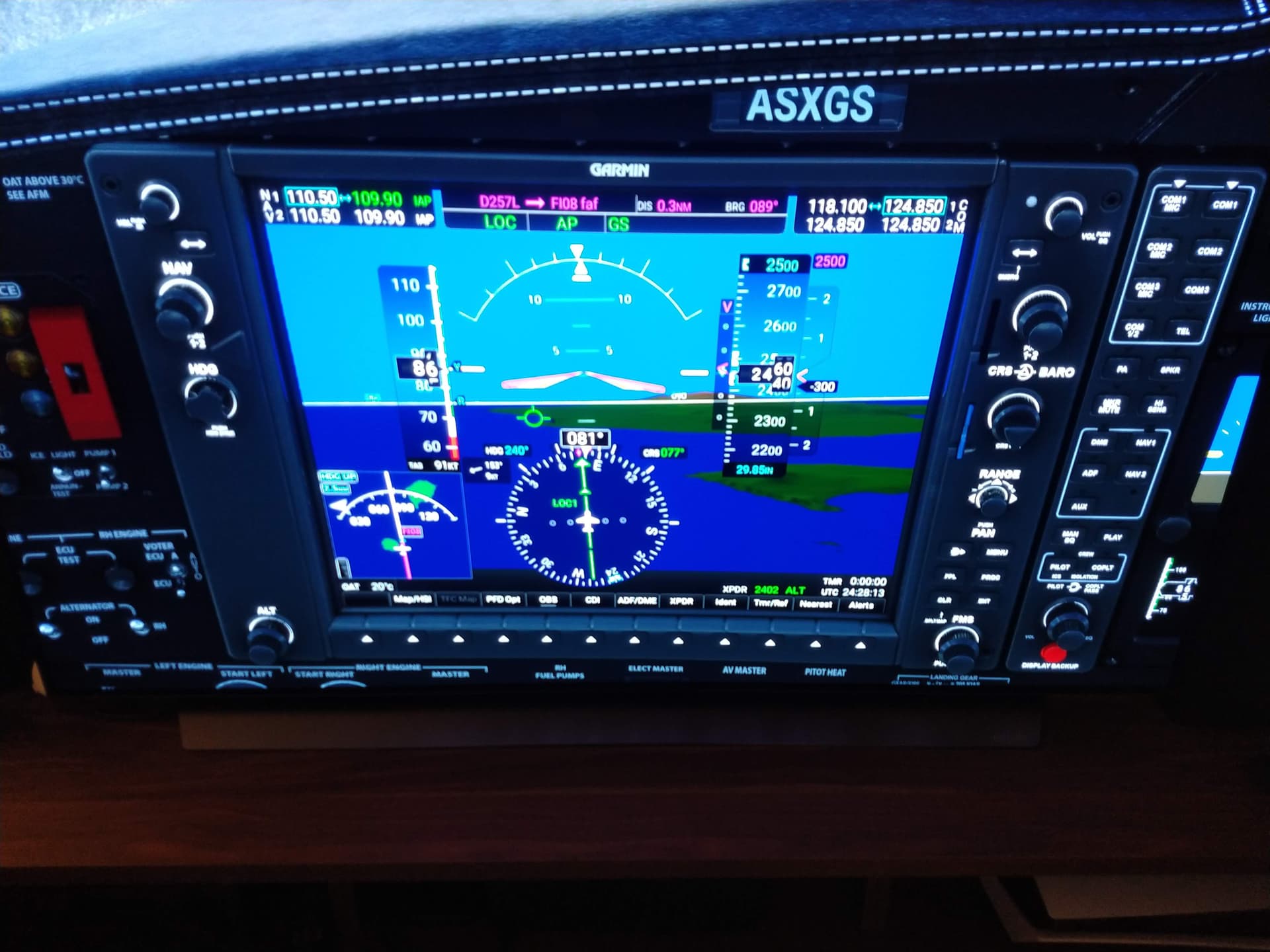
Working Title Garmin G1000 NXi v0.12.2 on xbox - Congratulations on fixing the visual approaches bug. There is however a problem with ILS approaches.
The task – Using VNAV to navigate to the ILS glideslope intercept altitude then capturing and following the ILS glideslope to the runway.
How it was working before - My normal process is to arm VNAV and use it to descend to the ILS glideslope intercept altitude. I usually arm the approach at the same time I set up VNAV by clicking the APR button and a white GS appears on the GPS. When you reach top of descent VNAV becomes active and descends the aircraft to the ILS glideslope intercept altitude. When the glideslope is captured the glideslope indicator then changes from armed “white”” to active “green” and the CDI pointer changes to LOC1 and the aircraft descends on the captured glideslope. The transition from VNAV descent to glideslope descent is automatic.
The problem - The problem I’m experiencing now is that you can’t arm the approach until what appears to be the last part of the approach -i.e. when you click APR you don’t get a white armed “GS” appearing. What is happening is once you intercept the glideslope you get a green “LOC” and the CDI changes to “LOC1”, and only then can you can select APR. You generally get a green “GS” immediately (depending on the approach). However, having achieved both a green “LOC” and green “GS” (screen shot one), and with the aircraft descending on the captured glideslope, part way through the descent you get kicked out of the glideslope capture (screen shot two). You can then click APR again and provided you do it quickly enough you get the green “GS” indicator back and the aircraft continues to follow the glideslope down. I have tried this with multiple airports and multiple ILS approaches and consistently encounter the same problem.
That’s usually what I’ll
Yeah, that’s what I do now. But it’s interesting what the Garmin system will try to do when overshooting.
I’ll usually take a direct to the straight point wherever it makes sense along the route (50 to 10 nm out). With a towered airport they always clear for a straight when that’s done. I suppose IRL a pilot could work with the tower and request that for an airport they were not familiar with. I can see how the various uses of the word straight confuse new sim pilots.
With the effort Garmin put into the Visual Approach process, I wonder why they didn’t add something like a pattern entry assistance?
I started off with Garmin Visual Approaches before learning IFR approaches. I though visual approaches were simpler but in reality the IFR approaches are easier. Garmin Visual Approaches require more planning.
I wonder if the team can share how they are calculating the flight path marker position on the 3d panel. The current behaviour is obviously not correct, and none of the aircraft with HUD’s in the sim have the correct behaviour. Currently, the FPM’s kite along behind the “nose cross”, but they should be driven by vector math. Is the correct behaviour possible with the current SDK, or would this require custom coding?
Hmm shouldnt the LOC comes automaticly when i am on an ILS APR and hit the FAF on the correct ALT ?
Mine doesnt in C172 , so i the GlideScope never get activated..
Correct Frequencies are dialed in..
I’m not totally sure by what methodology you’re coming to that conclusion. The flight path marker currently matches the behavior of the real unit. In other words, it projects the present airplane trajectory into the SVT 3D space, with a reasonable degree of smoothing that matches the unit smoothing.
I can’t really say why specifically they should be driven by vector math (a number of mathematical approaches would work here), but as it turns out we actually do, as we use a spherical vector projection to project the current track and vertical angle to infinity using the sim’s SVT FOV and lens focal length.
Note that the real unit’s flight path marker does not attempt to project onto the terrain, but merely projects to infinity.
The SDK doesn’t have anything to do with flight path markers. You can certainly implement one with the data provided by the SDK, but just like nearly all of the NXi (and honestly all other flight sim products), is built on hundreds of thousands of lines of custom code.
You can see the code for the NXi here if you’re curious: msfs-avionics-mirror/src/workingtitle-instruments-g1000 at main · microsoft/msfs-avionics-mirror · GitHub
And specifically for the FPM: https://github.com/microsoft/msfs-avionics-mirror/blob/main/src/workingtitle-instruments-g1000/html_ui/Pages/VCockpit/Instruments/NavSystems/WTG1000/PFD/Components/FlightInstruments/FlightPathMarker.tsx
It should, for most stock airports (there are a small number where it won’t). Most third party airports do not have their frequency reference data set up properly for this to work, and you may have to switch manually.
This is something that Garmin pilots are well aware of as a thing to crosscheck, as there are situations in the real unit that will also not auto-switch the CDI.
Thanks @Bishop398 That was very helpful. One more question, on line 60, does planeState.gs return ground speed?