Hi all, especially WT folk. Pardon me for barging into this discussion being somewhat out of the loop - I currently don’t have Nxi installed because I am flying a ton with the PC-6 Porter and it’s not compatible as of now though before it, it was a must-have for me. Do we have any progress on things that need to happen in order for the Nxi to work with the PC-6 as designed? The minute it happens, the Nxi becomes a permanent install again. Many thanks and again, forgive me for interrupting the discussion.
Having trouble capturing the ils. When I get close to the destination rwy, I switch to the loc mode and check that I’m still in nav mode. However, I never capture the ils horizontal guidance. Instead, the plane just turns in circles until I finally cancel the autopilot and land manually. I would appreciate any suggestions on what I’m doing wrong. I get the loc indicator in pfd and even see the gs diamond but never get on the approach.
I don’t know for sure whether this would affect it, but is your flight plan perhaps suspended? You can tell if it as the OBS button will be replaced with SUSP, or perhaps SUS, I forget the actual label.
Hi,
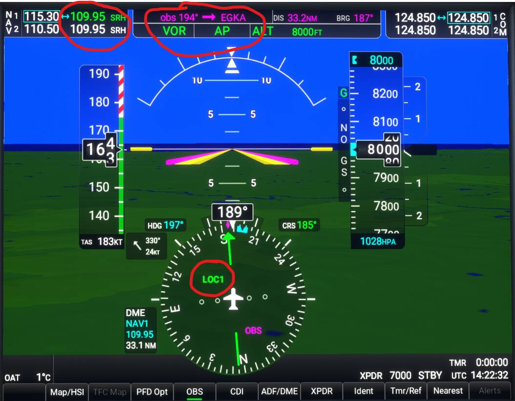
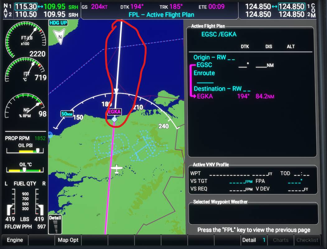
A strange thing just happened to me when I was trying some VOR navigation. I flew the Caravan from EGSC to EGKA, a short flight and I tried two VORs on the way:
- BPK at 117.50MHz
- SRH at 109.95 (close to EGKA)
Found issues:
-
Magenta line on the map seemed to extend beyond the destination airport
-
I couldn’t tune in to the second VOR (SRH 109.95) as either VOR1 nor VOR2 on the PFD, instead LOC1 was displayed. Could it be that the low frequency number fooled the system to think it was an ILS? Wikipedia says that VOR uses frequencies from 108.00 to 117.95.
-
When I changed the course the course at the top (obs 194–>EGKA) didn’t refresh, see image where course is 185.
-
VNAV was not working, I never saw the TOD.
Are you pressing approach when on final?
What exactly are you expecting to happen with the NXi? Did you familiarize yourself with the different procedure used with the NXi first?
SRH (Shoreham) in the UK is no longer a VOR. It is now a DME only, which is why the CDI does not indicate.
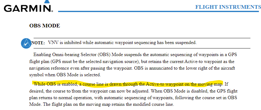
I think the extending line is due to having OBS turned on.
SRH might be out of service. SkyVector shows it as available in a list to add to the flight plan when you right-click on the airport in the chart, but their charts and maps do not actually show it as a VOR symbol. Also, I checked with Airportnavfinder.com, and they do not show SRH as a valid VOR.
Just guessing here, but if MSFS couldn’t find the VOR entered into NAV1 or NAV2, it might have just defaulted to LOC1?
Bill
Shew, this is a big topic. Is there a way to search within it?
I’m looking for how to load a saved flight plan in-sim, like how the GNS530 mod allows. Is this possible?
Click the search icon up top. Right below the search box that comes up is a box you can select for “search this topic”
Regards
good to know! unfortunately it said no results when i searched for “load saved flight plan”
1 Like
This is pc-only, unofficial, undocumented and may not work correctly for you.
- ESC - to open OPTIONS/PAUSE menu
- SPACE - to open LOAD/SAVE FLIGHT FILES menu box
- Select LOAD
- A Windows Open File selection box is displayed for your LocalState directory.
- NOTE: Only .flt saved flight files are listed for selection. The file type selection box is locked to only display .flt files.
- In the file name box, type in “.” (asterisk dot asterisk) and press the OPEN button.
- The list of files is refreshed and displays all the files in the LocalState directory.
- Select the flight plan .PLN file and press the OPEN button.
2 Likes
I know this has been discussed before, but I haven’t read the whole thread.
How do you find the total time for a flight plan that you created? I see the time to the next waypoint, but I can’t find the total time and distance. I opened the flt plan page but I still don’t see it…not on the PFD or MFD.
Thanks for looking at my simple question.
This doesn’t load a flight plan into the NXi, the way the PMS50 530/750 can do, but into the sim. The same way you can do it via the map screen.
Hey, this isn’t possible in the current beta version (0.7.1) I’m not sure what the plans are moving forward, I think I saw a conversation about the feature in their discord but can’t remember what the outcome was.
1 Like
ok thanks. good to know either way, now i can stop searching for how to do it
Is there a way to show the total trip time? Currently ETE shows the time to the next waypoint, but I’d like to show the total time.
I think you are right! SRH has no NAV capabilities! Strange though that it shows up as an ILS? Anyway, thanks for that! It is also strange that SRH shows up as a VOR on the MS flight planning map!

Yes, you are right, I found it in the manual. Also VNAV seams to stop functioning.
You never stop learning ![]()
1 Like
I have this issue too, which worsens the more I zoom in.