Yes they can fix it and it will be fixed. But I don’t know when and I don’t know if it will be an update, an add-on, or several add-ons for several areas.
Around Sydney there are no cliffs etc. The megalong valley and the Three Sisters look nothing like the real thing up close. Would be great to have some actual cliffs.

Where it works (French Alps, La Meije, 10 miles east of LFHU) :
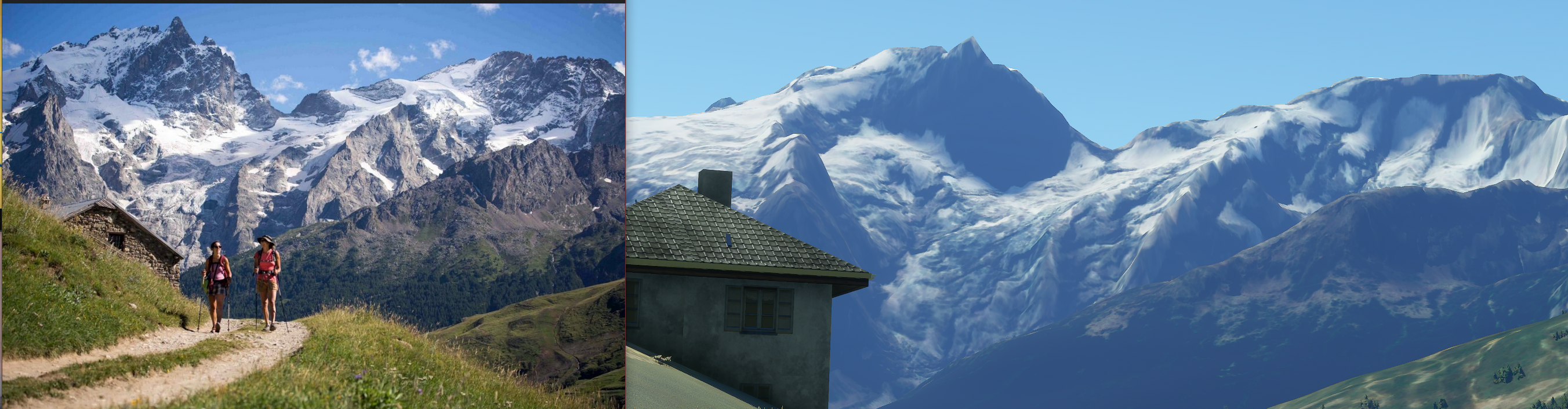
It lacks of details (I should have chosen another time of the day for better lighting), but the cliffs are here, the altitudes are respected, and it doesn’t look like the mountains have melted.
Where it doesn’t :

Mesh insconsistency at the estern end of Spanish/French boundary.
My opinion is that in France, the mesh is pretty good. I don’t know why (better source ? Asobo are French ?). It seems OK in the USA too. Some other countries are not as lucky.
I don’t know if the mesh is a part of the downloaded data or if it’s part of the installed ones. Let’s hope for improvement in the future updates.
The cliffs deserve a better rendering. But imo the “3 sisters” will never appear in the general mesh : this kind of detail is too small for the better meshes grid. But if it is a popular place, you have a good chance that someone will, one day, create 3D objets to render it.
well what surprises me the most (not in a good way) is that FS2020 just has way worse terrain data in general than Google Earth.
I mean: It’s not even close call. The terrain data, especially in the alps, but also just in general, is so much better in Google Earth, it’s crazy.
There is a lot that FS2020 does right (weather, clouds, planes, water, trees, etc), but the actual terrain… is quite a disappointment.
you can almost pick any spot you like, especially in mountain areas, and it will have at least 10x better resolution in Google Earth than in FS2020.
I hope we get a clear statement from the developers that they will implement better data.
But honestly: If they have better data… why don’t they use it already? Maybe they simply don’t have access to it… for what ever stupid legal reason for example.
We will see. But I want the same level of detail of mountains as I have on my 4 year old iPhone in Google Earth.
Maybe I ask for too much… but I don’t think so.
8 Likes
I raised a Zendesk request as well on the same topic. Hope something can be done soon.
Specifically (not sure if someone else have already reported), the Dolomites area in northern Italy is quite unrecognizable. This mountains are famous not only for being UNESCO World heritage, and the particular type of rock and color, but also because of their unique shape, as they have vertical cliffs and edges, hence you really need a high mesh to depict. In XPlane 11 with a ZL17 mesh (not incredibly detailed), their depiction is already very believable and the flying experience is unique. The impact of recognising the landscape mainly through terrain shapes and elevation is very significant, maybe even more than cities depiction (where at mid altitude). In the current MSFS2020, I could not recognise and also crashed a number of times because of non familiar (or maybe just not good at understanding elevation!). Anyway, it looked to me a enjoyable mountain scenery, only of an alien planet or another area of the world I did not explore. Would be good also to understand how to add custom mesh so you can import your own and add even more the granularity when you want (even with same textures). That would add realism a lot. Hope this can be fixed soon. Adding power lines, cablecars and mountain huts would be the next step…
3 Likes
My guess is that, at least until now, having a halfway decent terrain representation just wasn‘t important to Bing‘s paying customers (whoever they are). As I understood it, there are some updates going on at the moment. Whether mesh is part of it or not I’m not sure. The fact that Maps app now has better elevation data than a few months ago (although still far from perfect) might be indicative of this. Even if Bing doesn‘t implement proper elevation data, I‘m sure MSFS could do it, at least locally.
1 Like
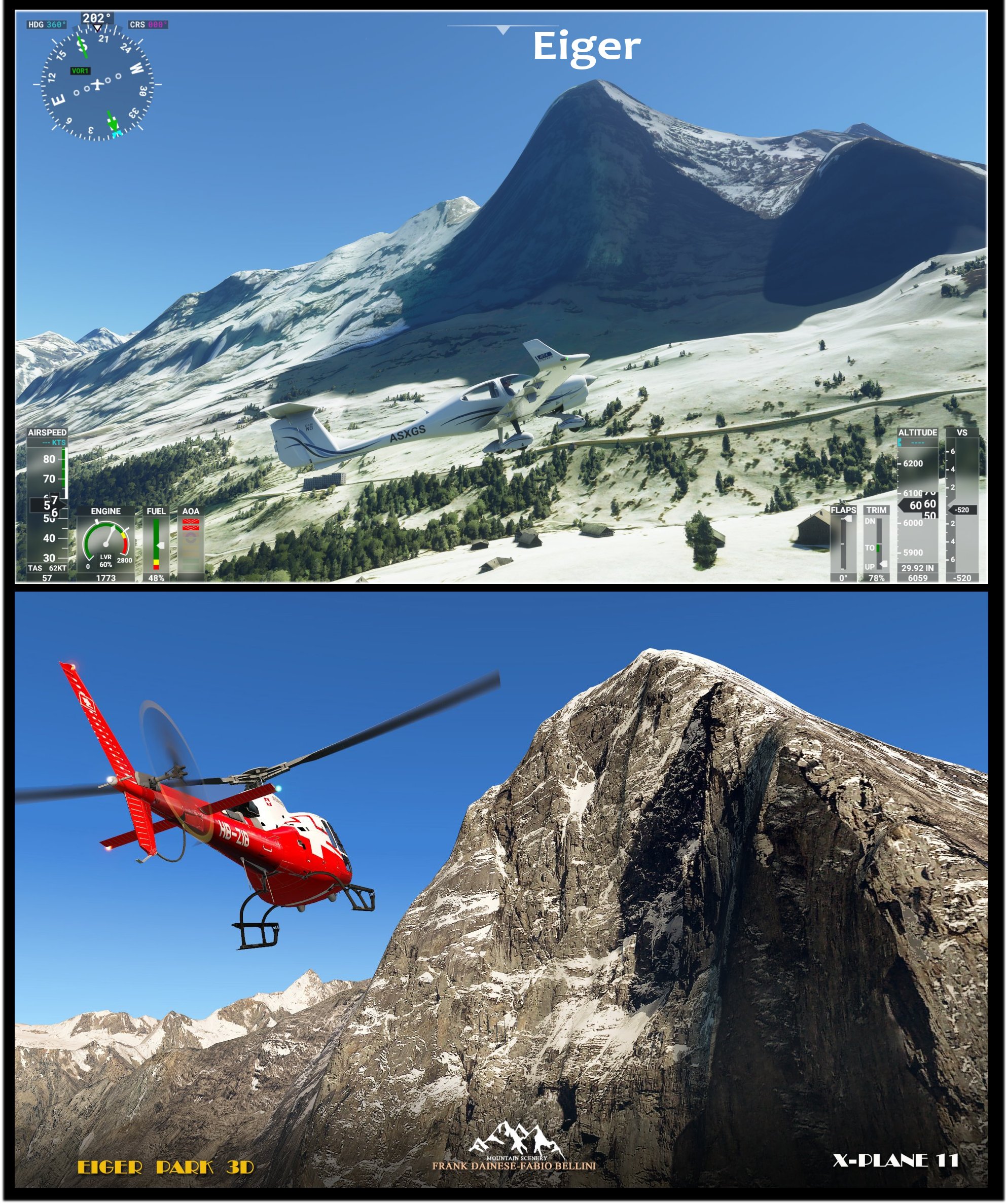
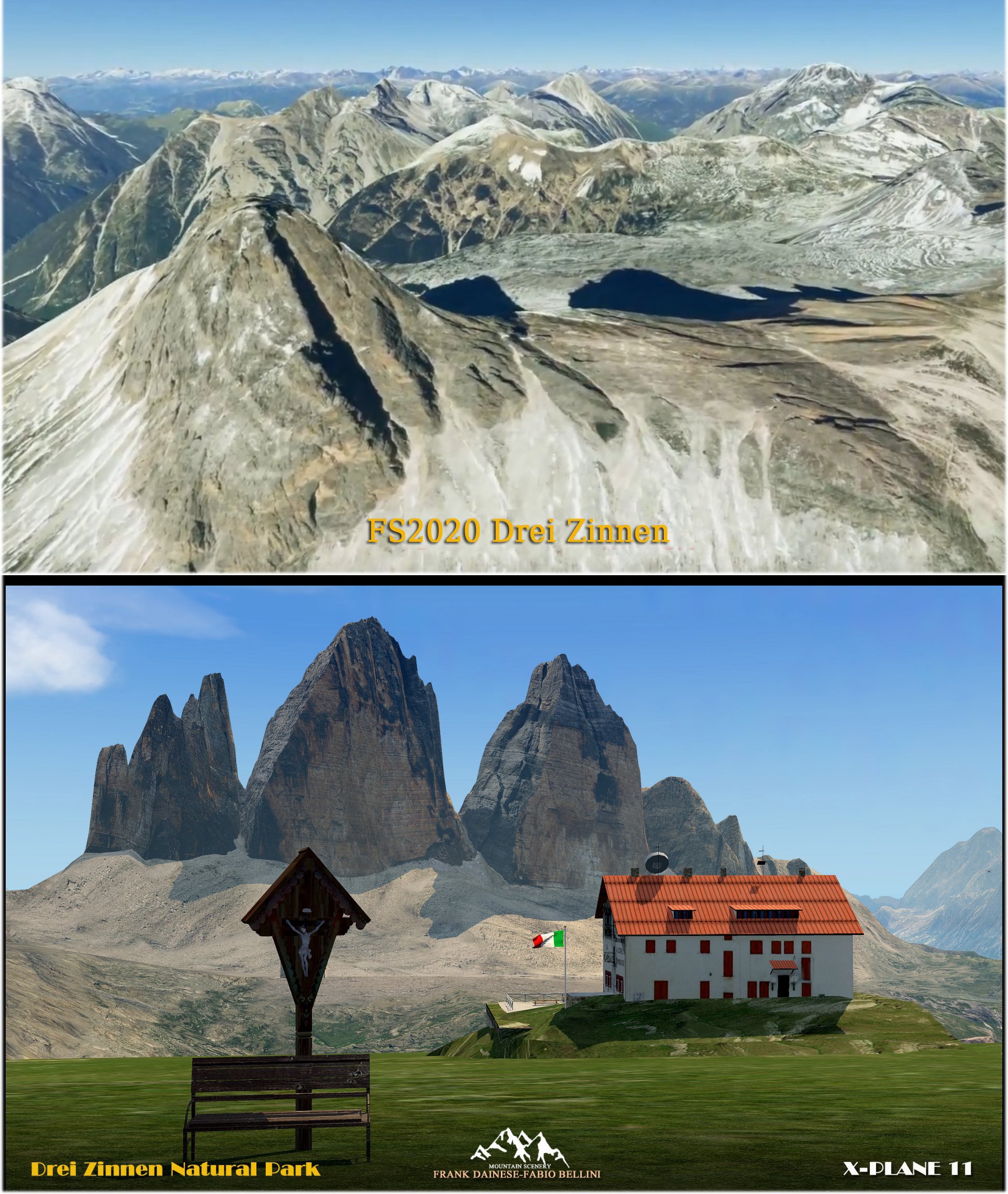
I’m Frank Dainese author of the mountain scenaries for XP11:
http://scenarialpinifsx.blogspot.com/
The method I used in XP11 is creation of complex 3D models of mountains with vertical walls (Dolomites, Matterhorn, Cerro Torre, Everest …) and then with the addition of 4K textures.
In MSFS I don’t find, for now, tools that facilitate the insertion of complex 3D models, a precision operation that must be mixed without smudging with the base mesh.


24 Likes
Thanks for the information Frank. Very interesting. That Eiger North Face and the Drei Zinnen look absolutely amazing.
I love flying over the Alps and know some of the places pretty well, also in real life. I like the new flight sim but I‘m avoiding flying there for now as it just doesn‘t look right. I really hope you‘ll find a way to bring this to MSFS. And I hope that MS/Asobo see your comparison screenshots and do something about it.
3 Likes
One of the bigger issues surrounding higher resolution mesh data is the performance hit it will take (besides other problems like availability, level of detail and not to forget putting 2D photos over 3D mesh will never be really good).
Everyone that has been using Ortho4XP for X-Plane (a software to create your own mesh and orthophoto scenery) knows, that you could easily end up with 20-30 million triangles in a 1° by 1° tile where you have mountainous terrain (high mesh resolution, smoothing for airports, smoothing for roads and train tracks, flattening of rivers and lakes etc.)
Put that on top of the rest of the scenery (trees, houses etc), systems (aircraft), weather and underlying computing processes and you will most likely disqualify any CPU that’s older than 2-3 years to run this sim on a setting that would render the visuals only halfway from what’s possible now and whith much worse performance.
1 Like
@Wookie042 I work in the field of 3D myself and I know these things quite well in general.
Sure, performance might be an issue, but that is no excuse that they basically killed mountains in FS2020 and made little hills instead. That’s just a bad joke.
There is always something you can do.
And saying “putting 2D photos over 3D mesh will never be really good”: That’s just wrong. If you properly UV map it, it’s no problem at all.
But it usually has to be man made, it probably can’t be automated. But mapping 2D images on a 3D mesh is the bread and butter of every 3D artist. It’s no big deal.
So I can’t acept these kind of excuses. They messed up and I hope they will fix it.
3 Likes
Another problem is disk space. I‘m sure MS don‘t want the game to be 500GB. One solution could be to confine very detailed mesh to places where it really matters (Himalayas, Alps, Andes etc). No need to have super mesh in Siberia or the Sahara. This would also solve the performance problem as there normally aren‘t any big cities in mountainous areas. In XPlane I have HD-mesh and ZL 19 orthos for the Alps and the performance on my mid-range PC is okay.
I suppose we will pay to third party for HD MESH. They intentionally left low mesh.
I really hate how bad European mountains looks in this simulation. Look at this:
I paid for this in X-Plane…
2 Likes
I‘m not so sure about that. They seem to be using the same mesh as Bing Maps, which from their perspective might make sense (no additional costs). The problem is just that Bing‘s mesh isn‘t that good, to say the least. I don‘t see any bad intentions here.
Great screenshot by the way. That‘s exactly what I‘d like to have in MSFS.
3 Likes
Hi Frank
thx for sharing this amazing pics. I live in Switzerland and its a pain to see the low mesh resolution in the swiss alps. I hope we get soon a solution to integrate such hi mesh Addons like yours into the sim. When it works i wil buy it a soon as possible
2 Likes
While you are right in general, especially for confined 3D models, remember we are talking about huge areas of the world in a flight simulator context. Also I think the statement I quoted is a little bit self-contradictory. No problem at all and can’t be automated is a bit of a dilemma here, isn’t it?
Besides that, I’m not sure where you read about excuses in my post. I only stated that this is a problem. Whether what I pointed out is the major problem here is of course debatable, but reading it as excuse is not.
And the statement “they messed up” is from what I see on my screen in regarding to mesh a bit exaggerated, don’t you think? There is lots of room for improvement (it’s always, regardless what we are talking about), but to state they messed up make me think the Alps or any other mountain range would be completely deformed or flat all together.
And don’t get me wrong, I would like as much you to fly over any mountain range, pull up some photos from Google or where ever and say “Yep, that’s this and that peak to 99% matching reality”
1 Like
Bing has low resolution mesh. Austria for instance has 10 m resolution mesh. I have it for X-Plane. What I see there and here is huge difference. Norway has 10 m mesh also… etc
Yes, I agree. I may have mistaken you. I was referring the the „intentionally left“ part. This sounded to me as if you insinuated that MS have left the mesh low-res on purpose, e.g. to make money with 3rd party products (have heard these kind of arguments many times). And that, I doubt. I could rather imagine that they just left it as is (i.e. Bing data) because that‘s cheaper and easier. But that‘s all just speculation of course. But forget about my comment if that‘s not what you meant.
Bing has just very poor quality in general unfortunatelly. Compared to Google Maps, it’s like a school project ^^
What I don’t get is why they use better terrain data where they could.
For Switzerland, they could just use the super highres data of Swisstopo for example.
The data existst…
1 Like
I agree with most of the comments, that the weather, the airplanes and the overall sim expierence is wonderful and a big leap in flight simulation. I do not regret having done the step to purchase that sim.
Still as an Austrian and knowing most of the area quite well I have to support this post as it seems that there is a lot to be done to get the alps close to what we see in real life.
Your pictures of Eiger, Mönch and Jungfrau show an interesting detail, which is that some of the bing map data was taken in winter time. The gras is obviously white in summertime. This needs to be corrected.
The same is true for the Austrian areas around the Traunstein, between Traunsee and Attersee as well as the area south of Dachstein. For the area around Traunstein this also results in the lack of LOLC airfield since the AI is only recognising a white field and places some bushes in the middle of the non-existing airfield
Traunstein, Schafberg and Dachstein, Grimming, Loser, etc. are only some more summits which would be intersting to have them rendered in high detail.
The data for all this exists, since ther was a FSX/P3D payware-addon made for the whole austrian area made by flugwerk.at
Further on the top of Dachstein glacier is a meeting point of bing map areas where one can see that there are definitly different colour shades within the map data. Since this is true for most of the Austrian area this would be another point where I see correction necessary, because it realy spoils the immersion if you see sharp lines, caused by different landclass colours, dividing a mountain.
Another thing I spotted so far are two villages (Niederöblarn and Bodensdorf) which look like someone spilled some grey ink on the map. There is no streets, and no map data vissible there.
Seems like more flat areas (danube region) do not suffer from the above mentioned limitations. There is only some autogen issues that could be changed.
Haven’t had the time to fly the western and most of the southern parts of my homecountry, so I can not tell to much about these areas.
3 Likes